
Loboc River: Difference between revisions
migrate to proper infobox |
|||
| Line 1: | Line 1: | ||
{{Infobox river |
|||
{{Geobox|River|category_hide=yes |
|||
| ⚫ | |||
<!-- *** Name section *** --> |
|||
| |
| name_native = |
||
| |
| name_native_lang = |
||
| ⚫ | |||
<!-- *** Map section *** --> |
|||
| |
| image = Loboc river.png |
||
| |
| image_size = 245px |
||
| ⚫ | |||
<!-- General section *** --> |
|||
| |
| image_alt = |
||
| |
| map = |
||
| |
| map_size = |
||
| |
| map_caption = |
||
| |
| map_alt = |
||
| |
| pushpin_map = Philippines |
||
| |
| pushpin_map_size = |
||
| pushpin_map_caption= |
|||
| ⚫ | |||
| |
| pushpin_map_alt = |
||
| subdivision_type1 = |
|||
| ⚫ | |||
| subdivision_name1 = |
|||
| ⚫ | |||
| subdivision_type2 = |
|||
| ⚫ | |||
| subdivision_name2 = |
|||
| ⚫ | |||
| subdivision_type3 = |
|||
| discharge = |
|||
| subdivision_name3 = |
|||
| ⚫ | |||
| subdivision_type4 = |
|||
| discharge_note = |
|||
| subdivision_name4 = |
|||
| discharge_max_month = |
|||
| subdivision_type5 = |
|||
| discharge_max = |
|||
| subdivision_name5 = |
|||
| discharge_min_month = |
|||
<!---------------------- PHYSICAL CHARACTERISTICS --> |
|||
| discharge_min = |
|||
| |
| length = |
||
| |
| width_min = |
||
| ⚫ | |||
<!-- *** Source *** --> |
|||
| |
| width_max = |
||
| |
| depth_min = |
||
| |
| depth_avg = |
||
| |
| depth_max = |
||
| discharge1_location= |
|||
| source_country = |
|||
| |
| discharge1_min = |
||
| discharge1_avg = |
|||
| ⚫ | |||
| discharge1_max = |
|||
| mouth_location = [[Loay, Bohol|Loay]] |
|||
<!---------------------- BASIN FEATURES --> |
|||
| mouth_region = |
|||
| |
| source1 = |
||
| source1_location = [[Carmen, Bohol|Carmen]] |
|||
| mouth_country = |
|||
| source1_coordinates= |
|||
| mouth_elevation = 0 |
|||
| source1_elevation = |
|||
| capital_coordinates = |
|||
| ⚫ | |||
| ⚫ | |||
| |
| mouth_location = [[Loay, Bohol|Loay]] |
||
| ⚫ | |||
| tributary_left1 = |
|||
| |
| mouth_elevation = |
||
| |
| progression = |
||
| |
| river_system = |
||
| |
| basin_size = {{Convert|520|km2|abbr=on}} |
||
| basin_landmarks = |
|||
<!-- *** Image *** ---> |
|||
| basin_population = |
|||
| ⚫ | |||
| |
| tributaries_left = |
||
| tributaries_right = |
|||
| ⚫ | |||
| waterbodies = |
|||
| ⚫ | |||
| ⚫ | |||
| ⚫ | |||
| custom_label = |
|||
| custom_data = |
|||
| ⚫ | |||
}} |
}} |
||
The '''Loboc River''' (also called '''Loay River'''<ref>{{cite web|title=Geographical Names: Loay, Philippines|url=http://www.geographic.org/geographic_names/name.php?uni=9139530&fid=4988&c=philippines|website=www.geographic.org|publisher=Geographic.org|accessdate=8 September 2016}}</ref>) is a river in the [[Bohol|Bohol province]] of the [[Philippines]]. It is one of the major tourist destinations of Bohol. |
The '''Loboc River''' (also called '''Loay River'''<ref>{{cite web|title=Geographical Names: Loay, Philippines|url=http://www.geographic.org/geographic_names/name.php?uni=9139530&fid=4988&c=philippines|website=www.geographic.org|publisher=Geographic.org|accessdate=8 September 2016}}</ref>) is a river in the [[Bohol|Bohol province]] of the [[Philippines]]. It is one of the major tourist destinations of Bohol. |
||
Revision as of 14:45, 8 December 2017
| Loboc River | |
|---|---|
 | |
.svg) | |
| Physical characteristics | |
| Source | |
| • location | Carmen |
| Mouth | Bohol Sea |
• location | Loay |
• coordinates | 9°42′15″N 124°07′04″E / 9.7042°N 124.1178°E |
| Basin size | 520 km2 (200 sq mi) |
The Loboc River (also called Loay River[1]) is a river in the Bohol province of the Philippines. It is one of the major tourist destinations of Bohol.
The source of the Loboc River is located in the town of Carmen, almost in the center of Bohol. From Carmen, the river takes a westerly course for a distance of about 1.5 kilometres (1 mi) then flows due south into the Mindanao or Bohol Sea. Its drainage area of approximately, 520 square kilometres (200 sq mi), is bordered by a horseshoe-shaped chain of mountain peaks rising to an elevation of 800 metres (2,600 ft). Rainfall is distributed almost uniformly throughout the year, thus Loboc River has a steady and high base flow.[2]
Attractions
A river cruise on a floating restaurant is the main activity that the Loboc River offers, attracting both local and foreign tourists.[3] The river cruises start in the Town of Loboc and travel upstream to the Busay Falls. Because of itsclean, green and peaceful river environment along with the local food served, the place is now widely known across the country.
Other attractions are hanging bridges over the river and paddle boarding.
Hydroelectricity
There is one hydroelectric plant on the Loboc River. Construction on the plant began in 1955, completed in 1957 and an expansion completed in 1968.[2]
| Date commissioned: | April 06, 1957 January 20, 1968 |
| Installed capacity: | 1.2 MW |
| Number of turbines: | 3 |
| Effective head: | 11.1 metres (36 ft) |
| Discharge: | 14.3 m3/s |
| Size of reservoir: | n/a (run-of-river) |
| Energy capability: | 9,450,000 KWH |
Gallery
-
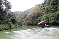 River cruise along the Loboc River
 -
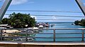 Mouth of the Loboc River at Loay
 -
 Coconut trees along the Loboc River
 -
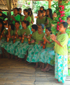 Local people perform native music on the floating restaurant.
 -
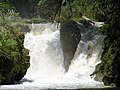 Busay Falls on Loboc River


References
- ^ "Geographical Names: Loay, Philippines". www.geographic.org. Geographic.org. Retrieved 8 September 2016.
- ^ a b "Loboc Hydroelectric Plant". www.napocor.gov.ph. National Power Corporation. Retrieved 8 September 2016.
- ^ "Loboc River Cruise and Floating Restaurant". www.boholtourismph.com. Official Bohol Tourism Office. 27 August 2015. Retrieved 8 September 2016.