Puerto Arica: Difference between revisions
Content deleted Content added
JJMC89 bot (talk | contribs) Migrate {{Infobox settlement}} coordinates parameters to {{Coord}}, see Wikipedia:Coordinates in infoboxes |
No edit summary |
||
| Line 12: | Line 12: | ||
|image_map = Colombia - Amazonas - Puerto Arica.svg |
|image_map = Colombia - Amazonas - Puerto Arica.svg |
||
|mapsize = 250px |
|mapsize = 250px |
||
|map_caption = Location of the |
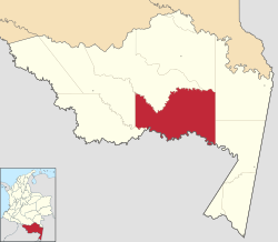
|map_caption = Location of the county of Puerto Arica |
||
|pushpin_map = Colombia |
|pushpin_map = Colombia |
||
|pushpin_mapsize =250 |
|pushpin_mapsize =250 |
||
|pushpin_map_caption =Location |
|pushpin_map_caption =Location of the town of Puerto Arica |
||
|subdivision_type = Country |
|subdivision_type = Country |
||
|subdivision_name = {{flag|Colombia}} |
|subdivision_name = {{flag|Colombia}} |
||
Revision as of 02:44, 18 January 2018
Puerto Arica | |
|---|---|
Municipality and town | |
 Location of the county of Puerto Arica | |
| Coordinates: 2°8′53″S 71°45′12″W / 2.14806°S 71.75333°W | |
| Country | |
| Department | Amazonas Department |
| Elevation | 96 m (315 ft) |
| Population (2015) | |
| • Total | 1,350 |
| Time zone | UTC-5 (Colombia Standard Time) |
| Climate | Af |
Puerto Arica is a town and municipality in the Colombian Department of Amazonas.

