Puerto Nariño
| Puerto Nariño | ||
|---|---|---|
|
Coordinates: 3 ° 46 ′ S , 70 ° 23 ′ W Puerto Nariño on the map of Colombia
|
||
|
Location of Puerto Nariño in the Amazon
|
||
| Basic data | ||
| Country | Colombia | |
| Department | Amazon | |
| City foundation | 1961 | |
| Residents | 8643 (2019) | |
| City insignia | ||
| Detailed data | ||
| surface | 1876 km 2 | |
| Population density | 5 people / km 2 | |
| height | 40 m | |
| City structure | 3 barrios | |
| Waters | Amazon | |
| Time zone | UTC -5 | |
| City Presidency | José Alberto Lozada Pinedo (2016–2019) | |
| Website | ||
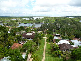
Puerto Nariño is a municipality ( municipality ) in Colombia in the Amazonas department on the Peruvian border directly on the Amazon River. The city owes its name to the famous Colombian general Antonio Nariño , who made an important contribution to the war of independence against Spain.
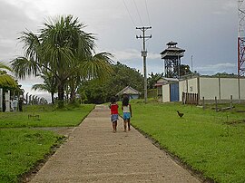
Most of the city's residents are of indigenous origin. Vehicles are not allowed in the city; the only way to get supplies is via the Amazon with motor boats.
geography
Puerto Nariño is located in the south of Colombia 1020 km from Bogotá at an altitude of between 40 m above sea level. NN and 150 m above sea level NN on the Amazon . The average temperature is 30 ° C with high humidity. The municipality borders on Leticia to the east, Tarapacá to the north and the Loreto region in Peru to the south and west .
population
The municipality of Puerto Nariño has 8643 inhabitants, of which 2247 live in the urban part (cabecera municipal) of the municipality (as of 2019).
history
Puerto Nariño was founded on August 18, 1961 as an office (corregimiento departamental) and became a municipality by decree in January 1984.
economy
Puerto Nariño's economy is based on ecotourism and fishing .
traffic
Puerto Nariño can be reached from Leticia by boat across the Amazon. A few paths lead through the rainforest to indigenous settlements.
Web links
- Alcaldía de Puerto Nariño - Amazon. Alcaldía del Municipio de Puerto Nariño - Amazonas, accessed April 19, 2019 (Spanish, website of the municipality).
Individual evidence
- ↑ a b c d Nuestro municipio. Alcaldía del Municipio de Puerto Nariño - Amazonas, accessed April 19, 2019 (Spanish, information on the geography of the municipality).
- ↑ ESTIMACIONES DE POBLACIÓN 1985 - 2005 Y PROYECCIONES DE POBLACIÓN 2005 - 2020 TOTAL DEPARTAMENTAL POR ÁREA. (Excel; 1.72 MB) DANE, May 11, 2011, accessed on April 19, 2019 (Spanish, extrapolation of the population of Colombia).


