Municipio (Colombia)
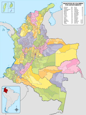
The municipalities in Colombia ( Spanish municipios ) are decentralized subdivisions of the third level, after the national level and the departmental level , and form the basic territorial unit of the political-administrative organization of the Colombian state . You enjoy political, fiscal and administrative autonomy within the framework of the Political Constitution of July 20, 1991 ( Constitución Política de Colombia 1991 ), as well as the law and this serves no other purpose than to ensure the general well-being and improve the quality of life of the population in their respective territories .
With citizen, social and community participation, the community is the privileged framework for public consultation on collective problems. The Alkalde ( Spanish alcalde ) heads the community and is the official title of a mayor or community leader .
structure
The country's 1,105 municipalities are grouped into 32 departments . Each parish has a parish seat , ( Spanish cabecera minicipal ). The administrative center of the municipality is installed in the municipality: mayor, police command, notary, court, seat of the municipal council. In many cases, the term "community" is applied to the municipal seat, sometimes from corregimientos and / or districts is (large urban areas of several municipalities compose it, are referred to as municipalities).
The Colombian municipalities - the largest is Cumaribo with 65,674 square kilometers and the smallest is Sabaneta with 15 square kilometers - partly have the area of German federal states (for comparison: Bavaria 70,550 square kilometers). They usually consist of several localities. The administrative area often includes both the central, mostly urban settlement that gives it its name, as well as the surrounding greater region , i.e. extensive rural areas.
Political importance
Politically, the community in Colombia is a cell of the state organism . Administratively, this is the unit with the greatest responsibility for the presentation of public services. Geographically, it is part of the state territory. The departmental assembly is responsible for the creation and elimination of municipalities, the separation and addition of urban areas and the organization of provinces. Finally, the public will, which is manifested in the consultation of the population, is an indispensable prerequisite for the creation of a new municipality. Such a popular will can be manifested before or after the approval of the departmental ordinance that issued it.
Functions
The local government also has to solve the problems related to public space , vehicle traffic , the market and public order . In addition, it is responsible for the provision of groundwater for drinking water and basic sanitation , the construction, maintenance and provision of official educational facilities , sports facilities and facilities for basic medical care . Management of the local health system , technical assistance for agriculture , allotment of vacant land by the Instituto Colombiano de Desarrollo Rural (INCODER), "Colombian Institute for Rural Development", implementation of integrated rural development programs, adaptation of road infrastructure and public services and Community services, co-financing of social housing; the maintenance and operation of ports and small rivers, the construction and maintenance of road networks, the regulation of urban traffic, the provision of public services for the home, the safety of citizens, the control and promotion of public order for peaceful coexistence as well as the consideration of disadvantaged population groups. The urban authorities also have important control and regulatory functions for land use and the resolution of conflicts with the Policía Nacional de Colombia (PNC), the national police of Colombia.
Municipalities by department
| Department | Municipios | Corregimientos |
|---|---|---|
|
|
2 | 9 |
|
|
125 | |
|
|
7th | 7th |
|
|
23 | |
|
|
46 | |
|
|
123 | |
|
|
27 | |
|
|
16 | |
|
|
19th | |
|
|
42 | |
|
|
25th | |
|
|
30th | |
|
|
30th | |
|
|
116 | |
|
|
1 | 8th |
|
|
4th | |
|
|
37 | |
|
|
15th | |
|
|
30th | |
|
|
29 | |
|
|
64 | |
|
|
40 | |
|
|
13 | |
|
|
12 | |
|
|
14th | |
|
|
2 | |
|
|
87 | |
|
|
26th | |
|
|
47 | |
|
|
42 | |
|
|
3 | 3 |
|
|
4th | |
|
|
1 |
Web links
- El Municipio Colombiano (Spanish)
See also
Individual evidence
- ↑ El municipio más grande de Colombia eltiempo.com , accessed on May 2, 2019 (Spanish)
- ↑ Information on geography on the Sabaneta official website sabaneta.gov.co, accessed April 24, 2019 (Spanish)
- ↑ Official website of INCODER ecured.cu retrieved (Spanish) on April 25, 2019
