Leticia
| Leticia | ||
|---|---|---|
|
Coordinates: 4 ° 12 ′ S , 69 ° 56 ′ W Leticia on the map of Colombia
|
||
|
Location of Leticia in Amazon
|
||
| Basic data | ||
| Country | Colombia | |
| Department | Amazon | |
| City foundation | 1867 | |
| Residents | 42,610 (2019) | |
| City insignia | ||
| Detailed data | ||
| surface | 5968 km 2 | |
| Population density | 7 people / km 2 | |
| height | 96 m | |
| Waters | Amazon | |
| Time zone | UTC -5 | |
| City Presidency | Jorge Luis Mendoza (2020-2023) | |
| Website | ||
| Streets in Leticia | ||
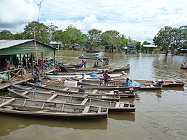
| The port of Leticia | ||
Leticia is a commune ( municipality ) in the extreme south of Colombia and the capital of Amazonas Department , which here with a narrow spur (160 × 40 square kilometers) from the Putumayo River and Rio Içá south to the Amazon rises.
| Leticia | ||||||||||||||||||||||||||||||||||||||||||||||||
|---|---|---|---|---|---|---|---|---|---|---|---|---|---|---|---|---|---|---|---|---|---|---|---|---|---|---|---|---|---|---|---|---|---|---|---|---|---|---|---|---|---|---|---|---|---|---|---|---|
| Climate diagram | ||||||||||||||||||||||||||||||||||||||||||||||||
| ||||||||||||||||||||||||||||||||||||||||||||||||
geography
The city of Leticia lies on the left bank of the Amazon and is an important port of this river. Leticia is located at the border triangle Colombia - Brazil - Peru , which is why it is also called Tres Fronteras (Spanish for three borders). It is the southernmost city of Colombia (4.09 ° south 69.57 ° west) and is 96 m above sea level. NN high. The average temperature is 27 ° C with high humidity.
On the same side of the river is Tabatinga , which belongs to Brazil. Leticia and Tabatinga have practically grown together today and you can go from one city to the other without any border control.
The Amacayacu National Park is located upstream, about 60 kilometers from Leticia.
The municipality borders on Puerto Nariño to the west, Tarapacá to the north, the Brazilian state of Amazonas to the east and the Yavarí district in the Mariscal Ramón Castilla province in the Loreto region of Peru to the south .
population
The municipality of Leticia has 42,610 inhabitants, of which 26,948 live in the urban part (cabecera municipal) of the municipality (as of 2019).
history
Leticia was founded on April 25, 1867 under the name San Antonio as a Peruvian river port. The name was established by the then governor of Loreto, Benigno Bustamante. On December 15 of the same year, the name was changed to Leticia on the initiative of the engineer Manuel Charón. Leticia came to Colombia through the Treaty of Salomón-Lozano in 1922.
In 1932/1933 Leticia was the scene and occasion of the Colombian-Peruvian War , also known as the "Leticia War".
In response to the forest fires in the Amazon rainforest in 2019 , seven countries bordering the Amazon (Colombia, Peru, Brazil, Ecuador, Bolivia, Suriname and Guyana) agreed the Leticia Pact for Amazonia , the measures, at a summit on September 6, 2019 in the municipality for better protection of the rainforest.
economy
Similar to the cities of Iquitos and Manaus , Leticia grew through the rubber boom at the beginning of the 20th century . Nowadays the biggest employers are fishing , logging and tourism . In addition, the plays Agriculture ( rice , bananas , corn and cassava ) and cross-border trade an important role.
traffic
Leticia cannot be reached via the Colombian road network from Bogotá, as there are almost 500 km of rainforest in between. Leticia has Alfredo Vásquez Cobo Airport , from which flights go to other Colombian cities as well as Peru. You can reach Iquitos in Peru and Manaus in Brazil from Leticia via the Amazon. In the city itself, the motorcycle is the main mode of transport.
Web links
- Alcaldía de Leticia - Amazon. Alcaldía del Municipio de Leticia - Amazonas, accessed April 19, 2019 (Spanish, website of the municipality).
Individual evidence
- ↑ a b c d Nuestro municipio. Alcaldía del Municipio de Leticia - Amazonas, accessed April 19, 2019 (Spanish, information on the geography of the municipality).
- ↑ ESTIMACIONES DE POBLACIÓN 1985 - 2005 Y PROYECCIONES DE POBLACIÓN 2005 - 2020 TOTAL DEPARTAMENTAL POR ÁREA. (Excel; 1.72 MB) dane.gov.co , May 11, 2011, accessed on April 19, 2019 (Spanish, extrapolation of the population of Colombia).
- ↑ Thomas Fischer: Art. Leticiakrieg . In: Hermann Joseph Hiery (ed.): Lexicon for overseas history . Steiner, Stuttgart 2015, ISBN 978-3-515-10000-7 , pp. 481-482.
- ↑ Amazon countries want to better protect rainforests in the future. faz.net , September 7, 2019, accessed on September 7, 2019 .


