
Cúcuta
| Cúcuta | ||
|---|---|---|
|
Coordinates: 7 ° 54 ′ N , 72 ° 30 ′ W Cúcuta on the map of Colombia
|
||
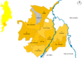
 Location of the municipality of Cúcuta on the map of Norte de Santander
|
||
| Basic data | ||
| Country | Colombia | |
| Department | North of Santander | |
| City foundation | 1733 | |
| Residents | 674,831 (2019) | |
| - in the metropolitan area | 892.732 | |
| City insignia | ||
 |
 |
|
| Detailed data | ||
| surface | 165 km 2 | |
| Population density | 4,090 inhabitants / km 2 | |
| height | 320 m | |
| City structure | 10 districts (comunas) | |
| Waters | Río Pamplonita , Río Táchira , Río Zulia | |
| Time zone | UTC -5 | |
| City Presidency | Jairo Tomás Yáñez (2020-2023) | |
| Website | ||
.jpg) |
||
 |
||

Cucuta (officially San José de Cúcuta ) is the seventh largest city of Colombia and capital as well as a municipality ( municipio ) in the department of Norte de Santander . The city is located in the northeast of the country on the border with Venezuela . Cúcuta is the center of the metropolitan area of Cúcuta .
geography
Geographical location
Cúcuta is about 320 meters above sea level and is about 600 kilometers from Bogotá and about 550 kilometers from Caracas in Venezuela . The city has an average temperature of 28 degrees Celsius. It is traversed by the Río Pamplonita, which flows into the Río Zulia at Puerto Santander . On the eastern edge of the city, on the border with Venezuela, runs the Río Táchira , which flows into the Río Pamplonita in the northeast of the city.
The municipality borders in the north on Tibú , Puerto Santander and the state of Zulia in Venezuela, in the east on the Venezuelan state of Táchira , in the south on Villa del Rosario , Los Patios and Bochalema and in the west on San Cayetano , El Zulia and Sardinata .
The eastern neighbor in Venezuela is Ureña . In the southeast, also in Venezuela, is the town of San Antonio , which forms a small “free zone” with Cúcuta; that is, the residents of both countries can move around in both cities. Due to the proximity to the border, there are only a few official petrol stations in Cúcuta. Much of the gasoline sold is illegally imported from Venezuela, where it is significantly cheaper. This has led to an informal trade in fuel in Cúcuta. However, the fuel is often adulterated and dirty.
population
In 1939 Cúcuta had 59,000 inhabitants; 1990 already 532,000. For 2019, the Departamento Administrativo Nacional de Estadística (DANE) extrapolates 674,831 inhabitants, of which 652,149 live in the urban part of the municipality (cabecera municipal) . 892,732 people live in the Cúcuta metropolitan area.
During the supply crisis in Venezuela, 30,000 people crossed the border at Cúcuta every day in summer 2018. An estimated 80,000 migrants had settled in the city, most of them surviving in the informal sector . Many were taken in by civilians who remembered the times when Colombians fled to safe and rich Venezuela. The university hospital recorded more Venezuelan births than Colombian births from summer 2018 due to the barely functioning hospitals in the neighboring country.
Homicides
According to a study by the organization El Consejo Ciudadano para la Seguridad Pública y la Justicia Penal ( German "Citizens' Council for Public Security and Criminal Law" ), Cúcuta is the third most dangerous city in Colombia and on the 50th place worldwide in 2017. A total of 290 murder cases in one Population of 833,743 corresponds to a homicide rate of 34.78 per 100,000 inhabitants.
Community structure
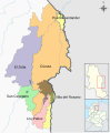
Comunas of Cúcuta

Rural part of Cúcuta
Metropolitan area of Cúcuta
.png)


The city is divided into ten districts ("comunas") , which in turn are divided into 6,185 districts ("barrios") . The rural area of the municipality of Cúcuta consists of ten corregimientos and nine "caseríos" (rural administrative subunits ).
- Comunas
- Centro
- Centro Oriental
- Sur oriental
- Oriental
- Nororiental
- Norte
- Noroccidental
- Occidental
- Suroccidental
- Cementerio
- Corregimientos
- Aguaclara
- Banco de Arena
- La Buena Esperanza
- El Soldado
- Puerto Villamizar
- Ricaurte
- San Faustino
- San Pedro
- Guaramito
- El Palmarito
- Caseríos
- Arrayanes
- Boconó
- Alto Viento
- El Carmen
- El Portico
- El Rodeo
- La Jarra
- Puerto León
- Puerto Nuevo
- Metropolitan area
In addition to Cúcuta, the Cúcuta metropolitan area includes the municipalities of Los Patios , Villa del Rosario , San Cayetano , El Zulia and Puerto Santander . The metropolitan area was officially formed in 1991.
climate
|
Average monthly temperatures and rainfall for Cúcuta
Source: wetterkontor.de
|
||||||||||||||||||||||||||||||||||||||||||||||||||||||||||||||||||||||||||||||||||||||||||||||||||||||||||||||||||||||||||||||||||||||||||||||||||||||||||||||||||||||||||||||||||||||||||||||||||||||||||||||||||||||||||||||||||||||||||||||||
history
Cúcuta was founded in 1733. Simón Bolívar conquered the city in 1813 and continued the march on Caracas from here . In 1821 the constituent congress of Greater Colombia met in the Rosary Church .
On May 18, 1875, the city was largely destroyed by an earthquake , but rebuilt relatively quickly. In 1888 Cúcuta was connected to the railway network.
Since 1956 Cúcuta has been the seat of the Roman Catholic diocese of Cúcuta . In 1962 the University of Francisco de Paula Santander was founded in Cúcuta. In addition, there is a campus of Pamplona University , which was founded in 1960.
Infrastructure
Cúcuta has an airport , the Aeropuerto Internacional Camilo Daza ( IATA airport code : CUC), which Avianca , LAN Colombia , Copa Airlines Colombia and Satena fly to several times a day and connects the city with all major cities in Colombia.
Sports

Cúcuta is home to the Cúcuta Deportivo football team , which currently plays in the second division . The club's greatest success was winning the first division championship in 2006 . The venue of Cúcuta Deportivo is the Estadio General Santander , which has 42,901 spectators.
Cúcuta was one of the venues for the 1982 World Basketball Championship and the sole venue for the 1955 South American Basketball Championship and the 1984 South American Basketball Championship for women .
sons and daughters of the town
- Virgilio Barco (1921–1997), Colombian President 1986–1990
- Fabiola Zuluaga (* 1979), former tennis player
- Damián Santín (* 1980), Uruguayan football player
- James Rodríguez (* 1991), football player
- María Camila Osorio Serrano (* 2001), tennis player
Web links
- Alcaldia de Cúcuta. Alcaldía de Cúcuta - Norte de Santander, accessed April 9, 2019 (Spanish, website of the municipality).
- Universidad Francisco de Paula Santander. Universidad Francisco de Paula Santander, accessed on April 9, 2019 (Spanish, website of the Universidad Francisco de Paula Santander).
Individual evidence
- ↑ ESTIMACIONES DE POBLACIÓN 1985 - 2005 Y PROYECCIONES DE POBLACIÓN 2005 - 2020 TOTAL DEPARTAMENTAL POR ÁREA. (Excel; 1.72 MB) DANE, May 11, 2011, accessed on April 9, 2019 (Spanish, extrapolation of the population of Colombia).
- ↑ The great exodus from Venezuela. In: NZZ. Retrieved July 29, 2018 .
- ^ Refugee misery on Venezuela's borders. In: Radio SRF "International". Retrieved November 3, 2018 .
- ↑ The 50 Most Dangerous Cities in the World. Retrieved March 29, 2018 .
- ↑ Universidad de Pamplona - Reseña Histórica. In: www.unipamplona.edu.co. Retrieved December 17, 2015 .
Ábrego | Arboledas | Bochalema | Bucarasica | Cáchira | Cácota | Chinácota | Chitagá | Convención | Cúcuta | Cucutilla | Durania | El Carmen | El Tarra | El Zulia | Gramalote | Hacarí | Herrán | La Esperanza | La Playa de Belén | Labateca | Lot Patios | Lourdes | Mutiscua | Ocaña | Pamplona | Pamplonita | Puerto Santander | Ragonvalia | Salazar | San Calixto | San Cayetano | Santiago | Sardinata | Silos | Teorama | Tibú | Toledo | Villa Caro | Villa del Rosario
Arauca ( ARA ) | Armenia ( QUI ) | Barranquilla ( ATL ) | Bogotá ( CUN ) | Bogotá (DC) * | Bucaramanga ( SAN ) | Cali ( VAC ) | Cartagena ( BOL ) | Cúcuta ( NSA ) | Florencia ( CAQ ) | Ibagué ( TOL ) | Inírida ( GUA ) | Leticia ( AMA ) | Manizales ( CAL ) | Medellín ( ANT ) | Mocoa ( PUT ) | Montería ( COR ) | Mitú ( VAU ) | Neiva ( HUI ) | Pasto ( NAR ) | Pereira ( RIS ) | Popayán ( CAU ) | Puerto Carreño ( VID ) | Quibdó ( CHO ) | Riohacha ( LAG ) | San Andrés ( SAP ) | San José del Guaviare ( GUV ) | Santa Marta ( MAG ) | Sincelejo ( SUC ) | Tunja ( BOY ) | Valledupar ( CES ) | Villavicencio ( MET ) | Yopal ( CAS )
* = Capital district