Villavicencio
| Villavicencio | ||
|---|---|---|
|
Coordinates: 4 ° 9 ′ N , 73 ° 39 ′ W Villavicencio on the map of Colombia
|
||
|
Location of the municipality of Villavicencio on the map of Meta
|
||
| Basic data | ||
| Country | Colombia | |
| Department | Meta | |
| City foundation | 1840 | |
| Residents | 527,673 (2019) | |
| - in the metropolitan area | 641.634 | |
| City insignia | ||
| Detailed data | ||
| surface | 1338 km 2 | |
| Population density | 394 inhabitants / km 2 | |
| height | 467 m | |
| Waters | Río Guatiquía | |
| Time zone | UTC -5 | |
| City Presidency | Juan Felipe Harman Ortiz (2020-2023) | |
| Website | ||
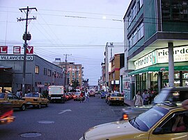
| Center of Villavicencio | ||
| View of Villavicencio | ||
Villavicencio is the capital and a municipality ( municipio ) in the Colombian Departamento del Meta . Villavicencio is the seat of a Roman Catholic archdiocese .
geography
Villavicencio is located about 86 kilometers southeast of Bogotá on the Guatiquía River at an altitude of 423 m between the Andes and the Venezuelan-Colombian plain of the Llanos in the Department del Meta. The climate is tropical with an average annual temperature of 27 ° C.
The municipality of Villavicencio borders in the north on El Calvario and Restrepo , in the east on Puerto López , in the south on San Carlos de Guaroa and Acacías and in the west on Acacías and Guayabal in Cundinamarca .
- Metropolitan area
In addition to Villavicencio, the municipalities of Acacías , Cumaral , Guamal and Restrepo belong to the unofficial metropolitan region of Villavicencio . The intention is to officially form the metropolitan area.
Climate table
|
Average monthly temperatures and rainfall for Villavicencio
Source: wetterkontor.de
|
||||||||||||||||||||||||||||||||||||||||||||||||||||||||||||||||||||||||||||||||||||||||||||||||||||||||||||||||||||||||||||||||||||||||||||||||||||||||||||||||||||||||||||||||||||||||||||||||||||||||||||||||||||||
population
The municipality of Villavicencio has 527,673 inhabitants, of which 503,407 live in the urban part (cabecera municipal) of the municipality. 641,634 people live in the metropolitan region (as of 2019).
history
The area around today's Villavicencio belonged to the Jesuits - Hacienda Apiay , until the Jesuits were ruled by King Charles III in 1767 . expelled from Spain and the lands secularized. The lands were transferred from the Spanish crown to Basilio Romero. In 1792 the hacienda was acquired by the siblings Jacinta and Vicente Rey. Their heirs sold the land piece by piece, resulting in the settlement of Apiay, which consisted mainly of traders, ranchers and colonists and, according to oral tradition, was de facto founded after 1836 and legalized in 1840 and named after the Gramalote river. The families of the traders Esteban Aguirre and Santos Reina are considered to be the founders. The oldest surviving official documents on Gramalote date from 1842. In 1845 a church was built. In 1850 the place was renamed in honor of the freedom fighter Antonio Villavicencio (1775-1816).
economy
Originally, Villavicencio was a stopping point and market for agricultural products on the way from the Llanos to Bogotá. Therefore, Villavicencio is still today a sub-center of its agricultural surrounding area characterized by trade and industry, in which mainly maize , rice , bananas and sorghum are grown and cattle are kept.
Research Institute for Tropical Biology
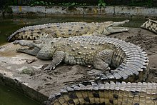
The German zoologist Friedrich Johann Graf von Medem (1912–1984) set up the “Estación de Biología Tropical” there in the early 1960s. On the farm, he raised and examined crocodiles and turtles. It became the starting point for many scientific expeditions for international guest researchers.
traffic
In Villavicencio there is the Vanguardia Airport ( IATA code : VVC, ICAO : SKVV) with a 1712 m long runway.
Sports
The football club Llaneros FC , founded in 2012, is based in Villavicencio and plays its home games in the Estadio Manuel Calle Lombana and plays in the Colombian second division . From 2002 to 2011 there was the now dissolved club Centauros Villavicencio , which played in the first division for a year .
Personalities
- Daniel Bazanta (1946–2012), percussionist
- Óscar Ruiz (* 1969), football referee
Web links
- Alcaldía de Villavicencio - Meta. Alcaldía de Villavicencio - Meta, accessed on June 11, 2019 (Spanish, website of the municipality of Villavicencio).
Individual evidence
- ^ Información del municipio. Alcaldía de Villavicencio - Meta, accessed June 11, 2019 (Spanish, information on the geography of the municipality).
- ↑ 5 municipios del Meta buscan que se Villavicencio convierta en área metropolitana. eltiempo.com, January 28, 2009, accessed June 11, 2019 (Spanish).
- ↑ ESTIMACIONES DE POBLACIÓN 1985 - 2005 Y PROYECCIONES DE POBLACIÓN 2005 - 2020 TOTAL DEPARTAMENTAL POR ÁREA. (Excel; 1.72 MB) DANE, May 11, 2011, accessed on June 11, 2019 (Spanish, extrapolation of the population of Colombia).
- ↑ Economía. Alcaldía de Villavicencio - Meta, accessed June 11, 2019 (Spanish, information on the municipality's economy).


