Yopal
| Yopal | ||
|---|---|---|
|
Coordinates: 5 ° 20 ′ N , 72 ° 23 ′ W Yopal on the map of Colombia
|
||
|
Location of the municipality of Yopal on the map of Casanare
|
||
| Basic data | ||
| Country | Colombia | |
| Department | Casanare | |
| City foundation | 1915 | |
| Residents | 152,655 (2019) | |
| City insignia | ||
| Detailed data | ||
| surface | 2595 km 2 | |
| Population density | 59 people / km 2 | |
| height | 350 m | |
| Waters | Río Cravo Sur | |
| Post Code | 850001-850009 | |
| City Presidency | Luis Eduardo Castro (2020-2023) | |
| Website | ||
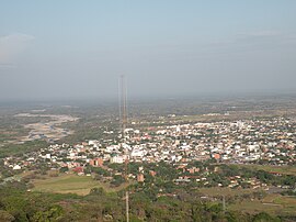
| View of Yopal | ||
| Park in Yopal | ||
| Yopal Cathedral | ||
Yopal is the capital and a municipality ( municipio ) in the Colombian department of Casanare .
geography
Yopal is located in the Colombian Llanos at the foot of the Andes in Casanare on the Río Cravo Sur . The total area of the municipality is 2771 km², of which 10.47 km² are in the urban part. The urban part is located at an altitude of 350 meters, 387 km from Bogotá. The annual average temperature is 26 ° C. The municipality borders in the north on Nunchía and Paya in the Departamento de Boyacá , in the south on Orocué and Maní , in the east on San Luis de Palenque and in the west on Aguazul and Labranzagrande in Boyacá.
population
The municipality of Yopal has 152,655 inhabitants, of which 137,174 live in the urban part (cabecera municipal) of the municipality (as of 2019). The city has seen tremendous growth over the past 50 years, albeit in irregular spurts. From the 3,122 inhabitants of Yopal in 1951, the population increased to 86,860 in 2003, an increase of 28 times. The community currently has growth rates almost five times higher than the Colombian national average.
history
Before the Spanish conquest, the area belonged to the Achaguas Indians. The Achaguas obtained a psychoactive drug from the seeds and bark of the Yopo tree, called Yopa in their language . Yopal means "forest of yopo trees". The Achaguas also cultivated cassava , pineapple and other plants in the area and traded goods with the mountain tribes.
Jesuit missionaries arrived in the area around 1650 and lived in isolated courtyards.
The modern history of Yopal begins with the building of a house in the then uninhabited city center by Elías Granados in 1915. The square developed into a transit point for local and regional cattle trade. In 1928 three more houses were added, including that of Pedro Pablo González, who is considered the actual founder of the place. Since 1932 there was a school in the growing town.
Yopal has had the status of a municipality since 1942 and Yopal has been the capital of Casanare since 1973.
economy
Yopal's most important industry is cattle production . In addition, oil production plays an important role, even if no oil is extracted in the community itself, but in neighboring communities. However, many companies have their headquarters in Yopal. In agriculture , rice , corn , coffee , cassava , bananas and oil palm are grown.
traffic
Yopal has one airport, El Alcaraván Airport . There are road connections to Bogotá, Boyacá, Villavicencio and the interior of Casanare.
Sports
Between 2002 and 2006, the soccer club Pumas de Casanare , which played in the second Colombian division , was based in Yopal . Pumas de Casanare was runner-up in the second division in 2003 and narrowly missed promotion to the first division . The club played its home games at the Estadio Santiago de las Atalayas , which has a capacity of approximately 9,000 spectators. The stadium served as the home stadium for Cúcuta Deportivo in 2012 and Alianza Petrolera in 2013 , during which stadiums were rebuilt.
Web links
- Alcaldía Municipio de Yopal. Alcaldía de Yopal - Casanare, accessed on June 5, 2019 (Spanish, website of the municipality of Yopal).
Individual evidence
- ↑ a b c d Nuestro municipio. Alcaldía de Yopal - Casanare, accessed June 5, 2019 (Spanish, information on the municipality).
- ↑ ESTIMACIONES DE POBLACIÓN 1985 - 2005 Y PROYECCIONES DE POBLACIÓN 2005 - 2020 TOTAL DEPARTAMENTAL POR ÁREA. DANE, May 11, 2011, accessed on June 5, 2019 (Spanish, extrapolation of the population of Colombia (Excel; 1.72 MB)).


