
Santa Marta
| Santa Marta | ||
|---|---|---|
|
Coordinates: 11 ° 14 ′ N , 74 ° 12 ′ W Santa Marta on the map of Colombia
|
||
 Location of the municipality of Santa Marta on the map of Magdalena
|
||
| Basic data | ||
| Country | Colombia | |
| Department | Magdalena | |
| City foundation | July 29, 1525 | |
| Residents | 515,717 (2019) | |
| - in the metropolitan area | 716,569 | |
| City insignia | ||
 |
|
|
| Detailed data | ||
| surface | 1472 km 2 | |
| Population density | 350 people / km 2 | |
| height | 2 m | |
| Waters | Caribbean | |
| Time zone | UTC -5 | |
| City Presidency | Virna Lizi Johnson Salcedo (2020-2023) | |
| Website | ||
 |
||
 |
||
 |
||

Santa Marta is the capital and a municipality ( municipio ) in the Department of Magdalena in Colombia . Santa Marta has been the seat of the diocese of Santa Marta since 1534 .
geography
Santa Marta is located on the Caribbean coast of Colombia , 992 km from Bogotá . To the southeast of the urban part, the municipality has a share of the Sierra Nevada de Santa Marta with the highest mountains in Colombia, the Pico Cristóbal Colón and the Pico Simón Bolívar , both with a height of 5775 meters above sea level. The ruined city of Ciudad Perdida is located in the Sierra Nevada in the municipality . To the north of the urban area is the fishing and tourist town of Taganga , a corregimiento of Santa Marta.
To the east of the municipality is the Tayrona National Park . The charm of the landscape lies on the one hand in the Caribbean with its warm water and coral reefs directly on the beach and on the other hand in the snow-capped peaks of the Sierra Nevada.
The municipality borders the Caribbean Sea to the north and west, Ciénaga and Aracataca to the south and Dibulla in La Guajira and Valledupar in the Department of Cesar to the east .
population
The municipality of Santa Marta has 515,717 inhabitants, of which 499,249 live in the urban part (cabecera municipal) of the municipality. 716,569 people live in the metropolitan region (as of 2019).
Political organization
Santa Marta is located in the Department of Magdalena . The city's mayor is democratically elected and governs for four years.
- Administrative division
| The urban area is divided into nine comunas: | The rural area of Santa Martas includes: | |
|
|
|
- Metropolitan area

In addition to Santa Marta, the municipalities of Ciénaga , Puebloviejo and Zona Bananera belong to the unofficial metropolitan area of Santa Marta .
history
The city was founded on July 29, 1525 by the Conquistador Rodrigo de Bastidas as one of the first Spanish cities that still exist today on the American mainland. Approx. 16 km from the city center is the Quinta de San Pedro de Alejandrino , where the freedom fighter Simón Bolívar died on December 17, 1830 .
Pre-Columbian period
Before the arrival of the Europeans, the South American continent was inhabited by a number of indigenous groups. Due to a combination of tropical weather, significant rainfall, and the destruction and corruption of many records by Spanish conquistadors , our understanding of the peoples of this region is limited.
The Tairona formed medium to large population centers consisting of stone paths, terraces, protected waterways and areas for agricultural products. Their economy consisted primarily of farming and growing corn , pineapple , cassava, and other local foods. The Tayrona are considered to be quite advanced for their period. The preserved archaeological sites consist of formed terraces and small underground stone channels. The most important preserved site of the Tairona is the Ciudad Perdida ( Spanish Lost City ), also Teyuna (indigenous name). The Tairona were also known to actively collect and process salt, which was an important commodity. We know that they traded with other indigenous groups along the coast and inland. Archaeological excavations have found significant works in the fields of ceramics , stone carving and goldsmithing .
economy
Santa Marta is not only an important port city with the handling of general cargo and coal, but also a tourist center with an extensive hotel area and entertainment venues. El Rodadero in particular is a popular summer retreat for Colombians with a wide range of discos and bars.
There is intensive agriculture around the city, palm trees, bananas and mango trees are planted. Bananas, some of which are sustainably grown in accordance with the SAN standard, are exported to Europe via the port.
Infrastructure
Santa Marta has an airport, Aeropuerto Simón Bolívar , which is served in particular from Bogotá , Medellín and Cali . By car Santa Marta is on the highways Troncal del Caribe (I-90), connecting the city with Barranquilla , Cartagena and Riohacha connects, and Troncal del Magdalena (I-45), which connects the city with the inland, are achieved. In the past, the Ferrocarril de Santa Marta railway was of great importance.
Sports
The soccer club Unión Magdalena is based in Santa Marta and has been playing in the Colombian second division since 2005 . The greatest success in the club's history so far has been the first division championship in 1968 . The original home stadium of Unión Magdalena was the Estadio Eduardo Santos , which was closed in 2013 due to dilapidation, which is why the club had to move to other cities for several years. Since 2018 the new home stadium of Unión Magdalena has been the Estadio Sierra Nevada , which was newly built for the Juegos Bolivarianos 2017. Three of the most important Colombian football players come from Santa Marta: Carlos Valderrama , Antony de Ávila and Falcao .

Estadio Sierra Nevada

Estadio Eduardo Santos

Statue of Carlos Valderrama


Town twinning
- Miami Beach , Florida , USA
- Bucaramanga , Santander , Colombia
gallery

Monument to the founder of the city of Rodrigo de Bastidas

Monument to Simon Bolivar
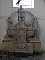
The tomb of Rodrigo de Bastidas in the cathedral
In the pedestrian zone

Cathedral (interior view)

In the central square

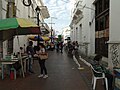
On one of the city streets


.jpg)


sons and daughters of the town
- José María Campo Serrano (1832–1915), first President of the Republic of Colombia
- Carlos "El Pibe" Valderrama (* 1961), football player
- Carlos Vives (* 1961), singer and actor
- Antony de Ávila (* 1962), football player
- Jorge Noguera Cotes (* 1963), lawyer and politician
- Jorge Eladio Bolaño (* 1977), national soccer player
- Falcao (* 1986), football player
- Johan Vonlanthen (* 1986), Swiss national soccer player
- Jesús Ferreira (* 2000), football player
Climate table
| Santa Marta | ||||||||||||||||||||||||||||||||||||||||||||||||
|---|---|---|---|---|---|---|---|---|---|---|---|---|---|---|---|---|---|---|---|---|---|---|---|---|---|---|---|---|---|---|---|---|---|---|---|---|---|---|---|---|---|---|---|---|---|---|---|---|
| Climate diagram | ||||||||||||||||||||||||||||||||||||||||||||||||
| ||||||||||||||||||||||||||||||||||||||||||||||||
|
Average monthly temperatures and rainfall for Santa Marta
Source: wetterkontor.de
|
|||||||||||||||||||||||||||||||||||||||||||||||||||||||||||||||||||||||||||||||||||||||||||||||||||||||||||||||||||||||||||||||||||||||||||||||||||||||||||||||||||||
Web links
- Santa Marta. Alcaldía de Santa Marta - Magdalena, accessed on June 11, 2019 (Spanish, website of the municipality of Santa Marta).
References and comments
- ↑ Geography. Alcaldía de Santa Marta - Magdalena, accessed June 11, 2019 (Spanish, information on the geography of the municipality).
- ↑ ESTIMACIONES DE POBLACIÓN 1985–2005 Y PROYECCIONES DE POBLACIÓN 2005–2020 TOTAL DEPARTAMENTAL POR ÁREA. (Excel; 1.72 MB) DANE, May 11, 2011, accessed on June 11, 2019 (Spanish, extrapolation of the population of Colombia).
- ↑ Panama City , founded in 1519, is the best known of the first Spanish cities in America, other earlier city foundations failed or do not have such central importance on the world map, such as the first Spanish city on mainland South America , Cumaná , which is still an important Venezuelan port city today .
- ↑ Historia. Alcaldía de Santa Marta - Magdalena, accessed June 11, 2019 (Spanish, information on the geography of the municipality).
- ↑ Christian Seiler: The banana is a stick. Portrait of our favorite fruit. Das Magazin, Tamedia, Zurich October 1, 2016, pp. 10–15.
- ↑ Nina Sigrist: The perfect banana. Migros Magazin Zurich, October 10, 2016, pp. 38–45.
- ↑ Alcalde de Santa Marta descarta restaurar el estadio Eduardo Santos. eltiempo.com, February 11, 2015, accessed June 11, 2019 (Spanish).
- ↑ Confirmado: el 'Ciclón' volverá a soplar en Santa Marta. seguimiento.co, December 12, 2017, accessed June 11, 2019 (Spanish).
- ↑ Se hizo oficial el regreso de Unión Magdalena a Santa Marta. futbolred.com, January 29, 2018, accessed June 11, 2019 (Spanish).
- ↑ http://www.miamibeachfl.gov/city-hall/tourism-culture-and-economic-development/culture-art-in-public-places/santa-marta-columbia/ ( page no longer available , search in web archives )
- ↑ Bucaramanga y Santa Marta ya son ciudades hermanas. vanguardia.com, July 6, 2009, accessed June 11, 2019 (Spanish).
Algarrobo | Aracataca | Ariguaní | Cerro de San Antonio | Chibolo | Ciénaga | Concordia | El Banco | El Piñón | El Retén | Fundación | Guamal | Nueva Granada | Pedraza | Pijiño del Carmen | Pivijay | Plato | Puebloviejo | Remolino | Sabanas de San Ángel | Salamina | San Sebastian de Buenavista | San Zenón | Santa Ana | Santa Bárbara de Pinto | Santa Marta | Sitionuevo | Tenerife | Zapayán | Zona Bananera
Arauca ( ARA ) | Armenia ( QUI ) | Barranquilla ( ATL ) | Bogotá ( CUN ) | Bogotá (DC) * | Bucaramanga ( SAN ) | Cali ( VAC ) | Cartagena ( BOL ) | Cúcuta ( NSA ) | Florencia ( CAQ ) | Ibagué ( TOL ) | Inírida ( GUA ) | Leticia ( AMA ) | Manizales ( CAL ) | Medellín ( ANT ) | Mocoa ( PUT ) | Montería ( COR ) | Mitú ( VAU ) | Neiva ( HUI ) | Pasto ( NAR ) | Pereira ( RIS ) | Popayán ( CAU ) | Puerto Carreño ( VID ) | Quibdó ( CHO ) | Riohacha ( LAG ) | San Andrés ( SAP ) | San José del Guaviare ( GUV ) | Santa Marta ( MAG ) | Sincelejo ( SUC ) | Tunja ( BOY ) | Valledupar ( CES ) | Villavicencio ( MET ) | Yopal ( CAS )
* = Capital district