Tunja
| Tunja | ||
|---|---|---|
|
Coordinates: 5 ° 32 ′ N , 73 ° 22 ′ W Tunja on the map of Colombia
|
||
|
Location of the municipality of Tunja on the map of Boyacá
|
||
| Basic data | ||
| Country | Colombia | |
| Department | Boyacá | |
| City foundation | 1539 | |
| Residents | 202,996 (2019) | |
| City insignia | ||
| Detailed data | ||
| surface | 118 km 2 | |
| Population density | 1,720 inhabitants / km 2 | |
| height | 2782 m | |
| Time zone | UTC -5 | |
| City Presidency | Alejandro Fúneme (2020-2023) | |
| Website | ||
| Tunja | ||
Tunja [ 'tuŋxa ] is the capital and a municipality ( municipio ) of the departments of Boyacá , Colombia . The city is located on a plateau on the western edge of the Eastern Cordillera of the Andes at an altitude of about 2800 m. This makes it - even before Bogotá - the highest located city in Colombia.
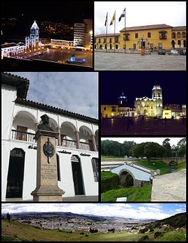
Tunja is a popular tourist destination , mostly for religious colonial architecture , with many churches and the Casa Fundador Gonzalo Suárez Rendón as its oldest holdover. In addition to its religious and historical sites, it is home to several internationally known festivals and is a starting point for regional tourism destinations such as Villa de Leyva , Paipa and the Sierra Nevada del Cocuy . Tunja is a stopover on the Panamericana , which connects Tunja with Bogotá and Santa Marta and finally with the northernmost and southernmost parts of South America.
The city is also known for its many universities. Tunja is also the seat of the Archdiocese of Tunja .
geography
Tunja has an area of 121 km² and is located about 150 kilometers northeast of the capital Bogotá. Tunja has an average annual temperature of 13 ° C. The municipality borders in the north on Motavita and Cómbita , in the east on Oicatá , Chivatá , Soracá and Boyacá , in the south on Ventaquemada and in the west on Samacá , Cucaita and Sora .
population
The municipality of Tunja has 202,996 inhabitants, of which 195,180 live in the urban part (cabecera municipal) of the municipality (as of 2019).
history
Pre-Columbian era
The first evidence of the human population on the Altiplano Cundiboyacense comes from around 12,000 years ago. The Homus Tequendama inhabited the area around 6375 BC. Many archaeological finds were made in the area of the present city, dating back to around 150 BC. To be dated.
In the 1st millennium AD the area was inhabited by the Muisca, who spoke Chibcha and emigrated from Central America via Panama to the Andean region. The Muisca developed their own religion, calendar, and mythology.
According to these myths, it was the brutal Cacique and prophet Goranchacha who moved the capital of the northern Muisca from Ramiriquí to Tunja, then called Hunza.
Spanish colony (1539-1811)
The city was founded on August 6, 1539 by the Spaniard Gonzalo Suárez Rendón from the Muisca settlement of Hunza , which had existed for several centuries . In 1574 the current cathedral of Tunja was completed.
Aspirations for independence
During the struggle for independence at the beginning of the 19th century, Tunja was a stronghold of the revolutionaries. The Battle of Boyacá took place near Tunja in 1819 .
Festivals
- International Festival of Culture
- Holy Week ( Semana Santa )
- Aguinaldo Boyacense
Sports
Tunja is the hometown of the soccer clubs Boyacá Chicó FC and Patriotas Boyacá , both of which play their home games at the Estadio La Independencia , which has a 25,000-seat audience. The stadium was built during the reign of the dictator Gustavo Rojas Pinilla and was extensively modernized because of Boyacá Chicó's participation in the 2009 Copa Libertadores .
In 2006 the South American Athletics Championships were held in Tunja .
| Tunja | ||||||||||||||||||||||||||||||||||||||||||||||||
|---|---|---|---|---|---|---|---|---|---|---|---|---|---|---|---|---|---|---|---|---|---|---|---|---|---|---|---|---|---|---|---|---|---|---|---|---|---|---|---|---|---|---|---|---|---|---|---|---|
| Climate diagram | ||||||||||||||||||||||||||||||||||||||||||||||||
| ||||||||||||||||||||||||||||||||||||||||||||||||
Town twinning
Sister cities of Tunja are:
-
 Italy : Potenza (2009)
 -
 Mexico : Tapachula
-
 Colombia : Pamplona (2012)
 -
 Colombia : Popayán (2012)
 -
 Colombia : Cúcuta
-
 Colombia : Valledupar
Sons and daughters
- Alfredo Gómez Jaime (1878–1946), poet
- Gustavo Rojas Pinilla (1900–1975), military, politician, dictator and President of Colombia
- Héctor Julio López Hurtado (* 1941), Bishop of Girardot
- Miguel Fernando González Mariño (* 1966), clergyman, auxiliary bishop in Ibagué
- Iván Casas (* 1980), racing cyclist
- Nairo Quintana (* 1990), racing cyclist
Web links
- Alcaldia Mayor de Tunja. Alcaldía de Tunja - Boyacá, accessed on June 5, 2019 (Spanish, website of the municipality of Tunja).
Individual evidence
- ↑ Geography. Alcaldía de Tunja - Boyacá, accessed June 5, 2019 (Spanish, information on the geography of the municipality).
- ↑ ESTIMACIONES DE POBLACIÓN 1985 - 2005 Y PROYECCIONES DE POBLACIÓN 2005 - 2020 TOTAL DEPARTAMENTAL POR ÁREA. (Excel; 1.72 MB) DANE, May 11, 2011, accessed on June 5, 2019 (Spanish, extrapolation of the population of Colombia).
- ↑ Historia. Alcaldía de Tunja - Boyacá, accessed June 5, 2019 (Spanish, information on the history of the municipality).
- ↑ https://www.municipio.com.co/municipio-tunja.html Tunja on municipio.com.co - El municipio de Tunja
- ↑ Los Niños Vallenatos del "Turco" Gil - Nacimos para alegrar al mundo . Retrieved November 25, 2017.


