Puerto Boyacá
| Puerto Boyacá | ||
|---|---|---|
|
Coordinates: 5 ° 59 ′ N , 74 ° 35 ′ W Puerto Boyacá on the map of Colombia
|
||
|
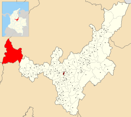
Location of the municipality of Puerto Boyacá on the map of Boyacá
|
||
| Basic data | ||
| Country | Colombia | |
| Department | Boyacá | |
| City foundation | 1957 | |
| Residents | 56,930 (2019) | |
| City insignia | ||
| Detailed data | ||
| surface | 1472 km 2 | |
| Population density | 39 inhabitants / km 2 | |
| height | 135 m | |
| Waters | Río Magdalena | |
| Time zone | UTC -5 | |
| City Presidency | Óscar Fernando Botero Alzate (2016–2019) | |
| Website | ||
Puerto Boyacá is a municipality ( municipio ) located on the Río Magdalena in the Department of Boyacá in Colombia . The entire area of the municipality, which extends mainly to the east from the city, is approximately 1,500 square kilometers.
geography
Puerto Boyacá is located on the Magdalena River in the Magdalena Medio zone in Boyacá , 373 km west of the departmental capital Tunja . Puerto Boyacá has an average temperature of 28 ° C. The municipality lies at the intersection of five Colombian departments. The municipality borders in the north Bolívar in the Departamento de Santander , in the south Puerto Salgar and Yacopí in the Departamento Cundinamarca , in the east Otanche in the Departamento de Boyacá and in the west Puerto Nare , Puerto Triunfo , Puerto Berrío and Sonsón in the Departamento de Antioquia and La Dorada in Departamento de Caldas .
population
The municipality of Puerto Boyacá has 56,930 inhabitants, of which 38,869 live in the urban part (cabecera municipal) of the municipality (as of 2019).
history
Today's Puerto Boyacá was a small settlement called Puerto Reyes until the middle of the 20th century , which arose from the search for natural rubber and corozo . In the meantime, the region belonged to the Departamento de Antioquia , but was reassigned to Boyacá in 1936. The town won in 1940 by oil drilling by Texaco in importance and was officially established in the sequence with the start of oil production in 1957 as Puerto Boyacá and received only shortly after the status of a community.
economy
The most important branch of the economy in Puerto Boyacá is oil production , which is now carried out by Ecopetrol in particular . In addition, cattle production and fishing play an important role.
sons and daughters of the town
- Fredy Guarín (* 1986), football player
Web links
- Alcaldia de Puerto Boyacá. Alcaldía de Puerto Boyacá - Boyacá, accessed on June 5, 2019 (Spanish, website of the municipality of Puerto Boyacá).
Individual evidence
- ^ Información del municipio. Alcaldía de Puerto Boyacá - Boyacá, accessed June 5, 2019 (Spanish, information on the geography of the municipality).
- ↑ ESTIMACIONES DE POBLACIÓN 1985 - 2005 Y PROYECCIONES DE POBLACIÓN 2005 - 2020 TOTAL DEPARTAMENTAL POR ÁREA. (Excel; 1.72 MB) DANE, May 11, 2011, accessed on June 4, 2019 (Spanish, extrapolation of the population of Colombia).
- ↑ Pasado, presente y futuro. Alcaldía de Puerto Boyacá - Boyacá, accessed June 5, 2019 (Spanish, information on the history of the municipality).
- ↑ Economía. Alcaldía de Puerto Boyacá - Boyacá, accessed June 5, 2019 (Spanish, information on the municipality's economy).


