Puerto Berrío
| Puerto Berrío | ||
|---|---|---|
|
Coordinates: 6 ° 29 ′ N , 74 ° 24 ′ W Puerto Berrío on the map of Colombia
|
||
|
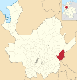
Location of the municipality of Puerto Berrío on the map of Antioquia
|
||
| Basic data | ||
| Country | Colombia | |
| Department | Antioquia | |
| City foundation | 1875 | |
| Residents | 50,232 (2019) | |
| City insignia | ||
| Detailed data | ||
| surface | 1184 km 2 | |
| Population density | 42 people / km 2 | |
| height | 125 m | |
| Waters | Río Magdalena | |
| Time zone | UTC -5 | |
| City Presidency | Jaime Andrés Cañas Morales (2016-2019) | |
| Website | ||
| Church in Puerto Berrío | ||
| Street in Puerto Berrío | ||
| Bridge over the Río Magdalena near Puerto Berrío | ||
Puerto Berrío is a municipality ( municipio ) in the Department of Antioquia in Colombia .
geography
Puerto Berrío is located in Antioquia , in the Magdalena Medio sub-region on the Río Magdalena , at an altitude of 125 m above sea level. NN 192 km from Medellin . The municipality is bordered to the north by Remedios and Yondó , to the northwest by Yolombó , to the west by Maceo and Caracolí , to the south by Puerto Nare and to the east by the Río Magdalena and Cimitarra and Bolívar in the Departamento de Santander and Puerto Boyacá in the Departamento de Boyacá .
population
The municipality of Puerto Berrío has 50,232 inhabitants, of which 45,393 live in the urban part (cabecera municipal) of the municipality (as of 2019).
history
After Colombia's independence, the area of today's Puerto Berrío initially belonged to the Santo Domingo district in the state of Antioquia. During the reign of President Manuel Murillo Toro and the Governor of Antioquia Pedro Justo Berrío , the area was infrastructured by a road from Medellín to the Río Magdalena. In 1874, under the direction of the Cuban engineer Francisco Javier Cisneros, the construction of a railway line from the Río Magdalena began during the term of office of the next governor. At the beginning of this a settlement was built on the river, which was named Puerto Berrío in honor of the previous governor in 1875. Due to the rapid growth, Puerto Berrío received the status of a district in 1881. The railway line was inaugurated in 1885 but was not completed until 1929. Until the 1970s, the city's economy was characterized by rail and river trade, which connected the interior of the country with the world. As a result, various social and political phenomena led the city into a crisis. For one thing, the railway line was abandoned. Puerto Berrío was also affected by the armed conflict in Colombia .
economy
Traditionally, the trade over the railway line and the Río Magdalena was the main industry of Puerto Berrío. The community's economy was hit hard by the armed conflict of the 1980s and 1990s. In recent years, however, the situation has calmed down, so that there are currently projects to revive river trade. The most important branch of the economy is currently cattle production .
education
In Puerto Berrío there is a location of the Universidad de Antioquia . The location was opened in 1997.
sons and daughters of the town
- Félix Muñoz (* 1959), leader of the FARC guerrilla group
- Alba Luz Arbeláez Álvarez (* 1965), botanist
Web links
- Alcaldía Municipal de Puerto Berrío en Antioquia. Alcaldía de Puerto Berrío - Antioquia, accessed on May 13, 2019 (Spanish, website of the municipality of Puerto Berrío).
Individual evidence
- ↑ a b c Nuestro municipio. Alcaldía de Puerto Berrío - Antioquia, accessed on May 13, 2019 (Spanish, information on the municipality).
- ↑ ESTIMACIONES DE POBLACIÓN 1985 - 2005 Y PROYECCIONES DE POBLACIÓN 2005 - 2020 TOTAL DEPARTAMENTAL POR ÁREA. (Excel; 1.72 MB) DANE, May 11, 2011, accessed on May 13, 2019 (Spanish, extrapolation of the population of Colombia).
- ↑ Magdalena Medio. Universidad de Antioquia, accessed on May 13, 2019 (Spanish, information on the location in Puerto Berrío).


