Nechí
| Nechí | ||
|---|---|---|
|
Coordinates: 8 ° 6 ′ N , 74 ° 47 ′ W Nechí on the map of Colombia
|
||
|
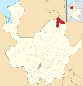
Location of the municipality of Nechí on the map of Antioquia
|
||
| Basic data | ||
| Country | Colombia | |
| Department | Antioquia | |
| City foundation | 1636 | |
| Residents | 29,270 (2019) | |
| City insignia | ||
| Detailed data | ||
| surface | 914 km 2 | |
| Population density | 32 people / km 2 | |
| height | 30 m | |
| Waters | Río Cauca , Río Nechí | |
| City Presidency | Miguel Enrique Fanco Menco (2016-2019) | |
| Website | ||
Nechi is a municipality ( municipio ) in the Department of Antioquia in Colombia .
geography
Nechí is located in the sub-region of Bajo Cauca in Antioquia, 358 km from Medellín , at an altitude of about 30 m above sea level. NN at the confluence of the Río Nechí in the Río Cauca and has an average temperature of 28 ° C. The municipality borders Ayapel in Córdoba and San Jacinto del Cauca in Bolívar in the north, Montecristo in Bolívar in the east, Caucasia and El Bagre in the south and Caucasia in the west.
population
The municipality of Nechí has 29,270 inhabitants, of which 15,691 live in the urban part (cabecera municipal) of the municipality (as of 2019).
history
Nechí was founded in 1636 under the name San Antonio de Bermejal and was a resting place for travelers on the Río Cauca . The place was named San José de Nechí in 1788 , of which Nechí finally remained. The administrative affiliation changed often up to the achievement of the municipality status in 1981.
economy
The main industries in Nechí are agriculture ( rice , corn , cassava , bananas and yams ), animal husbandry , mining ( gold and silver ), fishing , timber industry and handicrafts .
sons and daughters of the town
- Carlos Ospina (* 1982), racing cyclist
- Frank Fabra (* 1991), soccer player
Web links
- Alcaldía de Nechí Antioquia. Alcaldía de Nechí - Antioquia, accessed on May 13, 2019 (Spanish, website of the municipality of Nechí).
Individual evidence
- ↑ a b c Nuestro municipio. Alcaldía de Nechí - Antioquia, accessed on May 13, 2019 (Spanish, information on the municipality).
- ↑ ESTIMACIONES DE POBLACIÓN 1985 - 2005 Y PROYECCIONES DE POBLACIÓN 2005 - 2020 TOTAL DEPARTAMENTAL POR ÁREA. (Excel; 1.72 MB) DANE, May 11, 2011, accessed on May 13, 2019 (Spanish, extrapolation of the population of Colombia).


