
Santa Rosa de Osos
| Santa Rosa de Osos | ||
|---|---|---|
|
Coordinates: 6 ° 39 ′ N , 75 ° 28 ′ W Santa Rosa de Osos on the map of Colombia
|
||
 Location of Santa Rosa de Osos in Antioquia
|
||
| Basic data | ||
| Country | Colombia | |
| Department | Antioquia | |
| City foundation | 1636 | |
| Residents | 37,435 (2019) | |
| City insignia | ||
 |
 |
|
| Detailed data | ||
| surface | 812 km 2 | |
| Population density | 46 people / km 2 | |
| height | 2550 m | |
| Time zone | UTC -5 | |
| City Presidency | María del Carmen Roldán Arango (2016–2019) | |
| Website | ||
 |
||
 |
||
 |
||

Santa Rosa de Osos is a municipality ( municipio ) in the Department of Antioquia in Colombia .
geography
Santa Rosa de Osos is located in the sub-region Norte Antioqueño in Antioquia at an altitude of 2550 m above sea level. NN , 74 km north of Medellín and has an average temperature of 13 ° C. The municipality is bordered to the north by San Andrés , Yarumal , Angostura and Carolina , to the east by Carolina and Guadalupe , to the south by Donmatías , San Pedro de los Milagros and Entrerríos and to the west by Entrerríos, Belmira and San José de la Montaña .
population
The municipality of Santa Rosa de Osos has 37,435 inhabitants, of which 20,091 live in the urban part (cabecera municipal) of the municipality (as of 2019).
history
The area of Santa Rosa de Osos was discovered for the Spaniards in 1541 and named Valle de los Osos (Valley of the Bears) because of the large number of bears in the region . As a result, gold was found in the region . The place itself was founded in 1636. There has been a parish there since 1659. The first name was San Jacinto de Osos . The place has had its current name since 1811. In 1814 Santa Rosa got the status of a parish and since 1917 the place has been the seat of a diocese.
economy
Santa Rosa de Osos is strategically located on the way from Medellín to the Colombian Caribbean coast . Agriculture plays an important role. There are fruits , beans , sugar cane and coffee grown. In addition, cattle are bred, especially for milk production . There is also pig breeding . In the industrial sector, the food processing industry and the textile industry dominate .
religion
Santa Rosa de Osos is the seat of the diocese of Santa Rosa de Osos . In Santa Rosa de Osos, next to the cathedral, there is the pilgrimage church of the Basilica of Our Lady of Mercy .
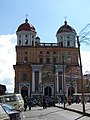
cathedral

Facade of the basilica

Iglesia de San Francisco y Santa Clara de Asís

Capilla de la Humildad


sons and daughters of the town
- Pedro Justo Berrío (1827–1875), governor of Antioquia
- Porfirio Barba Jacob (1883-1942), writer
- Aníbal Muñoz Duque (1908–1987), Archbishop of Bogotá (1972–1984) and Nueva Pamplona (1959–1968), Titular Bishop of Cariana (1968–1972), Bishop of Socorro y San Gil (1951–1952) and Bucaramanga (1952 –1959)
- César Alcides Balbín Tamayo (* 1958), Bishop of Caldas (2015–)
Web links
- Santa Rosa de Osos. Alcaldía de Santa Rosa de Osos - Antioquia, accessed on May 14, 2019 (Spanish, website of the municipality of Santa Rosa de Osos).
Individual evidence
- ^ Información del municipio. Alcaldía de Santa Rosa de Osos - Antioquia, accessed on May 14, 2019 (Spanish, information on the geography of the municipality).
- ↑ ESTIMACIONES DE POBLACIÓN 1985 - 2005 Y PROYECCIONES DE POBLACIÓN 2005 - 2020 TOTAL DEPARTAMENTAL POR ÁREA. (Excel; 1.72 MB) DANE, May 11, 2011, accessed on May 14, 2019 (Spanish, extrapolation of the population of Colombia).
- ↑ Pasado, presente y futuro. Alcaldía de Santa Rosa de Osos - Antioquia, accessed on May 14, 2019 (Spanish, information on the history of the municipality).
- ↑ Economía. Alcaldía de Santa Rosa de Osos - Antioquia, accessed on May 14, 2019 (Spanish, information on the municipality's economy).
Abejorral | Abriaquí | Alejandría | Amagá | Amalfi | Andes | Angelópolis | Angostura | Anorí | Anzá | Apartadó | Arboletes | Argelia | Armenia | Barbosa | Belmira | Bello | Betania | Betulia | Briceño | Buriticá | Cáceres | Caicedo | Caldas | Campamento | Cañasgordas | Caracolí | Caramanta | Carepa | Carolina | Caucasia | Chigorodó | Cisneros | Ciudad Bolívar | Cocorná | Concepción | Concordia | Copacabana | Dabeiba | Donmatías | Ebéjico | El Bagre | El Carmen de Viboral | El Peñol | El Santuario | Entrerríos | Envigado | Fredonia | Frontino | Giraldo | Girardota | Gómez Plata | Granada | Guadalupe | Guarne | Guatapé | Heliconia | Hispania | Itagüí | Ituango | Jardín | Jericó | La Ceja | La Estrella | La Pintada | La Unión | Liborina | Maceo | Marinilla | Medellín | Montebello | Murindó | Mutatá | Nariño | Necoclí | Nechí | Olaya | Peque | Pueblorrico | Puerto Berrío | Puerto Nare | Puerto Triunfo | Remedios | Retiro | Rionegro | Sabanalarga | Sabaneta | Salgar | San Andrés | San Carlos | San Francisco | San Jerónimo | San José de la Montaña | San Juan de Urabá | San Luis | San Pedro de los Milagros | San Pedro de Urabá | San Rafael | San Roque | San Vicente | Santa Bárbara | Santa Fe de Antioquia | Santa Rosa de Osos | Santo Domingo | Segovia | Sonsón | Sopetrán | Támesis | Tarazá | Tarso | Titiribí | Toledo | Turbo | Uramita | Urrao | Valdivia | Valparaíso | Vegachí | Venecia | Vigía del Fuerte | Yalí | Yarumal | Yolombó | Yondó | Zaragoza