Mutatá
| Mutatá | ||
|---|---|---|
|
Coordinates: 7 ° 15 ′ N , 76 ° 26 ′ W Mutatá on the map of Colombia
|
||
|
Location of the municipality of Mutatá on the map of Antioquia
|
||
| Basic data | ||
| Country | Colombia | |
| Department | Antioquia | |
| City foundation | 1850 | |
| Residents | 22,505 (2019) | |
| City insignia | ||
| Detailed data | ||
| surface | 1106 km 2 | |
| Population density | 20 people / km 2 | |
| height | 75 m | |
| City Presidency | Jairo Ortiz (2016-2019) | |
| Website | ||
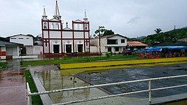
| Church in Mutatá | ||
Mutata is a municipality ( municipio ) in the Department of Antioquia in Colombia .
geography
Mutatá is located in the sub-region Urabá in Antioquia 358 km from Medellín at an altitude of about 75 m above sea level. NN and has an average temperature of 28 ° C. The municipality is bordered by Chigorodó and Turbo in the north, Dabeiba in the south, Riosucio in Chocó in the west and Ituango and Tierralta in Córdoba in the east .
population
The municipality of Mutatá has 22,505 inhabitants, of which 6038 live in the urban part (cabecera municipal) of the municipality (as of 2019).
history
Mutatá emerged from around 1850 through the settlement of people who were looking for stone nuts or wanted to go into mining . The original name was Pavarandocito . Mutatá received the status of a municipality in 1887.
economy
The main industry in Mutatá is agriculture . Manioc and pineapple in particular are grown. A potential in the development of ecotourism is seen.
Web links
- Alcaldía de Mutatá - Antioquia. Alcaldía de Mutatá - Antioquia, accessed on May 13, 2019 (Spanish, website of the municipality of Mutatá).
Individual evidence
- ↑ a b c Nuestro municipio. Alcaldía de Mutatá - Antioquia, accessed on May 13, 2019 (Spanish, information on the municipality).
- ↑ ESTIMACIONES DE POBLACIÓN 1985 - 2005 Y PROYECCIONES DE POBLACIÓN 2005 - 2020 TOTAL DEPARTAMENTAL POR ÁREA. (Excel; 1.72 MB) DANE, May 11, 2011, accessed on May 13, 2019 (Spanish, extrapolation of the population of Colombia).


