El Bagre
| El Bagre | ||
|---|---|---|
|
Coordinates: 7 ° 36 ′ N , 74 ° 49 ′ W El Bagre on the map of Colombia
|
||
|
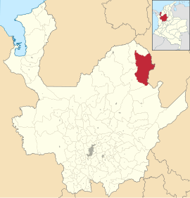
Location of the municipality of El Bagre on the map of Antioquia
|
||
| Basic data | ||
| Country | Colombia | |
| Department | Antioquia | |
| City foundation | 1653 | |
| Residents | 50,863 (2019) | |
| City insignia | ||
| Detailed data | ||
| surface | 1563 km 2 | |
| Population density | 33 people / km 2 | |
| height | 50 m | |
| Waters | Río Nechí , Río Tigüí | |
| Time zone | UTC -5 | |
| City Presidency | Faber Trespalacio (2020-2023) | |
| Website | ||
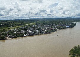
| El Bagre on the Río Nechí | ||
El Bagre is a municipality ( municipio ) in the Department of Antioquia in Colombia . The name is derived from the tiger spatula (el Bagre) found there .
geography
El Bagre is located in Antioquia , in the Bajo Cauca sub-region , at an altitude of 50 m above sea level. NN and has an area of 1563 km². El Bagre is located at the confluence of the Río Tigüí in the Río Nechí , a tributary of the Río Cauca . The municipality borders in the north on Nechí , in the south on Zaragoza and Segovia , in the east on the Serranía de San Lucas mountain range and on the municipality of Montecristo in the department of Bolívar and in the west on Caucasia and Zaragoza. El Bagre is about 170 km southeast of Montería and 200 km west of Cúcuta . After Medellin in the southwest there are 326 km and the capital Bogota is located 350 km south.
population
The municipality of El Bagre has 50,863 inhabitants, of which 26,176 live in the urban part (cabecera municipal) of the municipality (as of 2019).
history
The history of El Bagre is closely related to the history of Zaragoza and to gold mining since the time of the Spanish conquest. El Bagre was founded in 1653 by Fernando Alcántara. In 1980 it was raised to the parish.
economy
The economy is based on mining gold . El Bagre is the largest gold producer in Antioquia. There is also cattle breeding , wood cultivation and the extraction of natural rubber . El Bagre has an airport, Aeropuerto Medardo Abad Castañeda Céspedes ( IATA code : EBG ). The neighboring communities can be reached by roads or rivers.
Web links
- Alcaldía Municipal de El Bagre - Antioquia. Alcaldía de El Bagre - Antioquia, accessed on May 8, 2019 (Spanish, website of the municipality of El Bagre).
Individual evidence
- ^ Información del municipio. Alcaldía de El Bagre - Antioquia, accessed May 8, 2019 (Spanish, information on the geography of the municipality).
- ↑ ESTIMACIONES DE POBLACIÓN 1985 - 2005 Y PROYECCIONES DE POBLACIÓN 2005 - 2020 TOTAL DEPARTAMENTAL POR ÁREA. (Excel; 1.72 MB) DANE, May 11, 2011, accessed on May 8, 2019 (Spanish, extrapolation of the population of Colombia).
- ↑ Pasado, presente y futuro. Alcaldía de El Bagre - Antioquia, accessed May 8, 2019 (Spanish, information on the history of the municipality).
- ↑ Economía. Alcaldía de El Bagre - Antioquia, accessed May 8, 2019 (Spanish, information on the municipality's economy).
- ↑ Vías de comunicación. Alcaldía de El Bagre - Antioquia, accessed on May 8, 2019 (Spanish, information on the infrastructure of the municipality).


