Andes (Colombia)
| Andes | ||
|---|---|---|
|
Coordinates: 5 ° 39 ′ N , 75 ° 53 ′ W Andes on the map of Colombia
|
||
|
Location of the municipality of Andes on the map of Antioquia
|
||
| Basic data | ||
| Country | Colombia | |
| Department | Antioquia | |
| City foundation | 1852 | |
| Residents | 47,384 (2018) | |
| City insignia | ||
| Detailed data | ||
| surface | 403 km 2 | |
| Population density | 118 inhabitants / km 2 | |
| height | 1360 m | |
| prefix | 0057 4 | |
| Time zone | UTC -5 | |
| City Presidency | John Jairo Mejía Aramburo (2016-2019) | |
| Website | ||
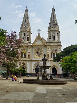
| View of Andes | ||
| Church of Nuestra Señora de las Mercedes in Andes | ||
Andes is a municipality ( municipality ) in the Antioquia department in Colombia .
geography
Andes is located in Antioquia , in the Suroeste sub-region , at an altitude of 1360 m above sea level. NN , 117 km from Medellin . The municipality borders in the north on Betania , Hispania and Pueblorrico , in the east on Jericó and Jardín , in the south on Mistrató in Risaralda and in the west on Bagadó in Chocó .
population
The municipality of Andes has 47,384 inhabitants, of which 24,046 live in the urban part (cabecera municipal) of the municipality (as of 2019).
history
Andes was founded in 1852 as part of the great inner-Colombian migration wave of the 19th century (colonización antioqueña) .
economy
Andes' main industries are agriculture , cattle production , mining, and trade .
education
In Andes there is a location of the Universidad de Antioquia . The location was opened in 1999.
sons and daughters of the town
- Gonzalo Arango (1931-1976), Colombian writer
- José Luis Henao Cadavid (* 1954), Bishop of Líbano-Honda (2015–)
Web links
- Alcaldia de Andes. Alcaldía de Andes - Antioquia, accessed on May 3, 2019 (Spanish, website of the municipality of Andes).
Individual evidence
- ^ Información del municipio. Alcaldía de Andes - Antioquia, accessed May 3, 2019 (Spanish, information on the geography of the municipality).
- ↑ ESTIMACIONES DE POBLACIÓN 1985 - 2005 Y PROYECCIONES DE POBLACIÓN 2005 - 2020 TOTAL DEPARTAMENTAL POR ÁREA. (Excel; 1.72 MB) DANE, May 11, 2011, accessed on May 3, 2019 (Spanish, extrapolation of the population of Colombia).
- ↑ Pasado, presente y futuro. Alcaldía de Andes - Antioquia, accessed May 3, 2019 (Spanish, information on the history of the municipality).
- ↑ Economía. Alcaldía de Andes - Antioquia, accessed May 3, 2019 (Spanish, information on the municipality's economy).
- ↑ Suroeste. Universidad de Antioquia, accessed on May 3, 2019 (Spanish, information on the location in Andes).


