
Guatapé
| Guatapé | ||
|---|---|---|
|
Coordinates: 6 ° 14 ′ N , 75 ° 10 ′ W Guatapé on the map of Colombia
|
||
 Location of the municipality of Guatapé on the map of Antioquia
|
||
| Basic data | ||
| Country | Colombia | |
| Department | Antioquia | |
| City foundation | 1811 | |
| Residents | 8363 (2018) | |
| City insignia | ||
 |
 |
|
| Detailed data | ||
| surface | 69 km 2 | |
| Population density | 121 people / km 2 | |
| height | 1925 m | |
| Waters | Peñol-Guatapé reservoir | |
| City Presidency | Juan Sebastian Pérez Flórez (2020-2023) | |
| Website | ||
 |
||
 |
||
.JPG) |
||

Guatapé is a municipality ( municipio ) in the Department of Antioquia in Colombia . Guatapé is known for the rock of Guatapé as well as for the colorful historical center with the pedestals designed in relief art. The community was named after an indigenous cacique .
geography
Guatapé is located about 75 kilometers from Medellín , the capital of Antioquia, at an altitude of about 1925 m above sea level. NN in the sub-region Oriente Antioqueño and has an average annual temperature of 20 ° C. The municipality has an area of 69 km², of which 68 km² are in the rural part of the municipality. Guatapé borders Alejandría in the north , El Peñol in the west, Granada in the south and San Rafael and San Carlos in the east .
In addition to the urban center, the municipality of Guatapé consists of the following parts of the municipality:

- El Roble
- La Peña
- La Piedra
- La Sonadora
- Los Naranjos
- Quebrada Arriba
- Santa Rita y Rosario
population
The municipality of Guatapé has 8363 inhabitants, 5420 of whom live in the urban part (cabecera municipal) of the municipality (as of 2018).
history
Before the Iberian conquistadors reached the area in the 16th century, this area was inhabited by indigenous ethnic groups, some of whom were controlled by a cacique named Guatape. In his honor, the city was named after him. The name "Guatapé" comes from the Quechua language. Another name that the city had in the past is "La Ceja de Guatapé".
The indigenous people living in the area of today's Guatapé municipality were resettled in the San Antonio de Remolinos de El Peñol reserve in 1714 .
Guatapé was founded on October 4th, 1811 by the Spaniard Don Francisco Giraldo y Jimenez. It was declared a parish in September 1867.
The originally agricultural community became a tourist center with the construction of the Peñol-Guatapé reservoir in the 1970s. In June 2017, the multi-storey tourist and leisure ship El Almirante capsized with 167 people on board. Nine people died in the accident.
economy
The most important economic sectors in Guatapé are energy generation through the hydroelectric power station of the San Carlos dam and tourism . There is also agriculture , animal husbandry , fishing , trade and the textile industry .
Sports
In Guatapé is the regatta course Villa Náutica Embalse de Guatapé , on which the competitions in canoeing and rowing of the South American Games 2010 in Medellín took place. In addition, the open water swimming , sailing and triathlon competitions were held in Guatapé .
tourism
Both the rock of Guatapé and the historic center of the place, which has cobblestone streets and brightly painted houses, are significant for tourism . The zócalos (pedestals), which are designed in relief art and depict various motifs from the history and everyday life of the region as well as geometric shapes, are an attraction . The church dedicated to Our Lady on Mount Carmel is located on the main square, which is well worth seeing . There are also two monasteries on the territory of the municipality. Tourist and leisure boats sail across the reservoir.
Infrastructure
Guatapé can be reached from Medellín via the Autopista Medellín-Bogotá . The junction towards Guatapé and El Peñol is behind the center of Marinilla . The two bus companies Sotra Sanvicente y Guatapé la Piedra and Sotrapeñol connect Guatapé with Medellín. Ship connections are offered on the reservoir.
gallery

Guatapé City Hall
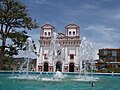
Maria-vom-Berg-Karmel-Church
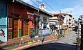
Street in Guatapé with typical Zócalos


Web links
- Guatapé. Alcaldía de Guatapé - Antioquia, accessed on May 10, 2019 (Spanish, website of the municipality of Guatapé).
Individual evidence
- ↑ Geography. Alcaldía de Guatapé - Antioquia, accessed on May 10, 2019 (Spanish, information on the geography of the municipality).
- ↑ Censo Nacional de Población y Vivienda - CNPV 2018. (Excel; 544 KB) DANE, accessed on January 9, 2020 (Spanish, 2018 census).
- ↑ Historia de Guatapé. Alcaldía de Guatapé - Antioquia, accessed on May 10, 2019 (Spanish, information on the history of the municipality).
- ↑ David Alejandro Mercado: hundimiento de 'El Almirante' no ahogo el turismo en Guatapé. eltiempo.com, June 25, 2018, accessed May 10, 2019 (Spanish).
- ↑ Economía. Alcaldía de Guatapé - Antioquia, accessed on May 10, 2019 (Spanish, information on the municipality's economy).
- ↑ Medellín 2010. Comité Olímpico Colombiano, accessed on May 10, 2019 (Spanish, information on the South American Games 2010).
- ↑ Danilo Betancur Giraldo: Guatapé. Turismo, color y alegría. las2orillas.com, July 19, 2017, accessed May 10, 2019 (Spanish).
- ↑ Vías de comunicaciones. Alcaldía de Guatapé - Antioquia, accessed on May 10, 2019 (Spanish, information on the infrastructure of the municipality).
Abejorral | Abriaquí | Alejandría | Amagá | Amalfi | Andes | Angelópolis | Angostura | Anorí | Anzá | Apartadó | Arboletes | Argelia | Armenia | Barbosa | Belmira | Bello | Betania | Betulia | Briceño | Buriticá | Cáceres | Caicedo | Caldas | Campamento | Cañasgordas | Caracolí | Caramanta | Carepa | Carolina | Caucasia | Chigorodó | Cisneros | Ciudad Bolívar | Cocorná | Concepción | Concordia | Copacabana | Dabeiba | Donmatías | Ebéjico | El Bagre | El Carmen de Viboral | El Peñol | El Santuario | Entrerríos | Envigado | Fredonia | Frontino | Giraldo | Girardota | Gómez Plata | Granada | Guadalupe | Guarne | Guatapé | Heliconia | Hispania | Itagüí | Ituango | Jardín | Jericó | La Ceja | La Estrella | La Pintada | La Unión | Liborina | Maceo | Marinilla | Medellín | Montebello | Murindó | Mutatá | Nariño | Necoclí | Nechí | Olaya | Peque | Pueblorrico | Puerto Berrío | Puerto Nare | Puerto Triunfo | Remedios | Retiro | Rionegro | Sabanalarga | Sabaneta | Salgar | San Andrés | San Carlos | San Francisco | San Jerónimo | San José de la Montaña | San Juan de Urabá | San Luis | San Pedro de los Milagros | San Pedro de Urabá | San Rafael | San Roque | San Vicente | Santa Bárbara | Santa Fe de Antioquia | Santa Rosa de Osos | Santo Domingo | Segovia | Sonsón | Sopetrán | Támesis | Tarazá | Tarso | Titiribí | Toledo | Turbo | Uramita | Urrao | Valdivia | Valparaíso | Vegachí | Venecia | Vigía del Fuerte | Yalí | Yarumal | Yolombó | Yondó | Zaragoza