Amagá
| Amagá | ||
|---|---|---|
|
Coordinates: 6 ° 2 ′ N , 75 ° 42 ′ W Amagá on the map of Colombia
|
||
|
Location of the municipality of Amagá on the map of Antioquia
|
||
| Basic data | ||
| Country | Colombia | |
| Department | Antioquia | |
| City foundation | 1788 | |
| Residents | 30,376 (2019) | |
| City insignia | ||
| Detailed data | ||
| surface | 84 km 2 | |
| Population density | 362 inhabitants / km 2 | |
| height | 1250 m | |
| prefix | 0057 4 | |
| Time zone | UTC -5 | |
| City Presidency | Wilser Darío Molina Molina (2016-2019) | |
| Website | ||
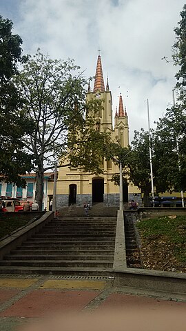
| Church in Amagá | ||
| Old Amagá train station | ||
| Belisario Betancur Cultural Center | ||
Amagá is a municipality ( municipality ) in the Antioquia department in Colombia .
geography
Amagá is located 36 km southwest of Medellín in the Suroeste sub-region in Antioquia at an altitude of approximately 1400 m above sea level. NN and has an average temperature of 21 ° C. The municipality borders Angelópolis in the north, Calda in the east, Fredonia and Venecia in the south and Titiribí in the west .
population
The municipality of Amagá has 30,376 inhabitants, of which 17,551 live in the urban part (cabecera municipal) of the municipality (as of 2019).
history
When the Spaniards arrived, the area of today's municipality was inhabited by the indigenous peoples of the Omogaes and Senufanaes . The region was settled by settlers of Spanish origin from Medellín from the 18th century. Amagá itself was founded in 1788 under the name San Fernando de Borbón . Since 1812 Amagá had the status of a district and since 1851 that of a canton. The development of the community was driven by the construction of the railway at the beginning of the 20th century.
economy
Amagá's most important cultivation product is coffee . In addition, the region is rich in fossil mineral resources such as coal and there is a lot of mining going on.
sons and daughters of the town
- Belisario Betancur (1923–2018), politician and Colombian President (1982–86)
- Jairo Salas (* 1984), racing cyclist
Web links
- Alcaldía de Amagá. Alcaldía de Amagá - Antioquia, accessed on May 3, 2019 (Spanish, website of the municipality of Amagá).
Individual evidence
- ^ Información del municipio. Alcaldía de Amagá - Antioquia, accessed May 3, 2019 (Spanish, information on the geography of the municipality).
- ↑ ESTIMACIONES DE POBLACIÓN 1985 - 2005 Y PROYECCIONES DE POBLACIÓN 2005 - 2020 TOTAL DEPARTAMENTAL POR ÁREA. (Excel; 1.72 MB) DANE, May 11, 2011, accessed on May 3, 2019 (Spanish, extrapolation of the population of Colombia).
- ↑ Pasado, presente y futuro. Alcaldía de Amagá - Antioquia, accessed on May 3, 2019 (Spanish, information on the history of the municipality).
- ↑ Economía. Alcaldía de Amagá - Antioquia, accessed May 3, 2019 (Spanish, information on the municipality's economy).


