Inírida
| Inírida | ||
|---|---|---|
|
Coordinates: 3 ° 52 ′ N , 67 ° 55 ′ W Inírida on the map of Colombia
|
||
|
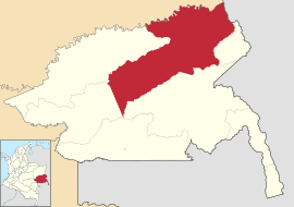
Location of the municipality of Inírida on the map of Guainía
|
||
| Basic data | ||
| Country | Colombia | |
| Department | Guainía | |
| City foundation | 1963 | |
| Residents | 20,478 (2019) | |
| City insignia | ||
| Detailed data | ||
| surface | 6457 km 2 | |
| Population density | 3 people / km 2 | |
| height | 95 m | |
| Post Code | 940001-940009 | |
| Time zone | UTC -5 | |
| City Presidency | Camilo Andrés Puentes Garzón (2016-2019) | |
| Website | ||
| Inírida airport | ||
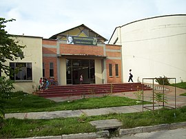
| Library of Inírida | ||
| The Río Inírida | ||
Inírida (formerly: Puerto Inírida ) is the capital and only municipality ( municipio ) in the Colombian department of Guainía in the river basin of the upper Orinoco in the Amazon basin .
geography
Inírida is located on the Río Inírida in eastern Colombia. Inírida is located at an altitude of about 100 meters about 600 km from Villavicencio and has an average temperature of 25 ° C. The total area of the municipality is 17,000 km². The northern border of the municipality forms the Río Guaviare and the eastern border of the Río Atrabapo . The municipality borders in the north on Cumaribo in the department of Vichada , in the south on the office of Puerto Colombia , in the east on the office of Cacahual and the Venezuelan state of Amazonas and in the west on the offices of Barranco Minas and Morichal .
population
The municipality of Inírida has 20,478 inhabitants, of whom 13,215 live in the urban part (cabecera municipal) of the municipality. Inírida is the largest settlement in the department.
history
Inírida was placed under the Vaupés Commissariat in 1963 . The place received the status of a municipality in 1974. At the same time Guainía became a commissariat and Inírida its capital. Since 1991 Guainía is a department with Inírida as its capital.
economy
Inírida serves as a transshipment point for regional products and raw materials. The main industries are mining , fishing and agriculture .
Infrastructure
Inírida is not connected to the Colombian road network. It can only be reached by water, especially from Villavicencio . Inírida has César Gaviria Trujillo Airport ( IATA code : PDA ) and can be reached by air from Bogotá and Villavicencio.
Web links
- Alcaldía de Inírida. Alcaldía de Inírida - Guainía, accessed on May 3, 2019 (Spanish, website of the municipality of Inírida).
Individual evidence
- ^ Información del municipio. Alcaldía de Inírida - Guainía, accessed on May 3, 2019 (Spanish, information on the geography of the municipality).
- ↑ ESTIMACIONES DE POBLACIÓN 1985 - 2005 Y PROYECCIONES DE POBLACIÓN 2005 - 2020 TOTAL DEPARTAMENTAL POR ÁREA. (Excel; 1.72 MB) DANE, May 11, 2011, accessed on May 3, 2019 (Spanish, extrapolation of the population of Colombia).
- ↑ Pasado, presente y futuro. Alcaldía de Inírida - Guainía, accessed on May 3, 2019 (Spanish, information on the history of the municipality).
- ↑ Economía. Alcaldía de Inírida - Guainía, accessed May 3, 2019 (Spanish, information on the municipality's economy).
- ↑ Vías de comunicación. Alcaldía de Inírida - Guainía, accessed on May 3, 2019 (Spanish, information on the infrastructure of the municipality).


