Paz de Ariporo
| Paz de Ariporo | ||
|---|---|---|
|
Coordinates: 5 ° 53 ′ N , 71 ° 54 ′ W Paz de Ariporo on the map of Colombia
|
||
|
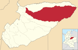
Location of the municipality of Paz de Ariporo on the map of Casanare
|
||
| Basic data | ||
| Country | Colombia | |
| Department | Casanare | |
| City foundation | 1953 | |
| Residents | 26,237 (2019) | |
| City insignia | ||
| Detailed data | ||
| surface | 13,793 km 2 | |
| Population density | 2 people / km 2 | |
| height | 270 m | |
| Waters | Río Ariporo , Río Meta , Río Guachiría , Río Muese , Río Casanare | |
| Time zone | UTC -5 | |
| City Presidency | Fabio Vega Galindo (2016-2019) | |
| Website | ||
| View of Paz de Ariporo | ||
Paz de Ariporo is a municipality ( municipio ) in the department of Casanare in Colombia .
geography
Paz de Ariporo is located in the northeast of Casanare at an altitude of about 270 meters in the Colombian Llanos 90 km from Yopal and 426 km from Bogotá . With an area of around 13,800 m², the municipality is one of the largest municipalities in Colombia and takes up 27% of the area of Casanare. The municipality borders in the north Hato Corozal , in the east Cravo Norte in the Departamento de Arauca and La Primavera in the Departamento de Vichada , in the south Trinidad and in the west Pore and Támara .
population
The municipality of Paz de Ariporo has 26,237 inhabitants, of which 19,294 live in the urban part (cabecera municipal) of the municipality (as of 2019).
history
The origins of Paz de Ariporo go back to the 18th century. The settlement at the foot of the Eastern Cordillera of the Andes in 1850 after the famous son of the city, the General Juan Nepomuceno Moreno, Moreno called. Moreno was the most important settlement in Casanare in the second half of the 19th century. However, the place suffered from the civil war and was in ruins in the middle of the 20th century. That is why Moreno was given up in 1953 and re-established at its current location, closer to the airport and in the middle of the Llanos. Because of the peace process that took place at the nearby Río Ariporo at that time , the place was called Paz de Ariporo . Paz de Ariporo has had parish status since 1974.
economy
The main industries are cattle production , agriculture , trade and oil production .
traffic
There is one airport in Paz de Ariporo ( IATA code : PZA ).
Web links
- Alcaldia de Paz de Ariporo - Casanare. Alcaldía de Paz de Ariporo - Casanare, accessed on February 8, 2019 (Spanish, website of the municipality).
Individual evidence
- ^ Información del municipio. Alcaldía de Paz de Ariporo - Casanare, accessed February 8, 2019 (Spanish, information on the geography of the municipality).
- ↑ ESTIMACIONES DE POBLACIÓN 1985 - 2005 Y PROYECCIONES DE POBLACIÓN 2005 - 2020 TOTAL DEPARTAMENTAL POR ÁREA. (Excel; 1.72 MB) DANE, May 11, 2011, accessed on February 8, 2019 (Spanish, extrapolation of the population of Colombia).
- ↑ Pasado, presente y futuro. Alcaldía de Paz de Ariporo - Casanare, accessed February 8, 2019 (Spanish, information on the history of the municipality).
- ↑ Economía. Alcaldía de Paz de Ariporo - Casanare, accessed February 8, 2019 (Spanish, information on the municipality's economy).


