San Luis de Palenque
| San Luis de Palenque | ||
|---|---|---|
|
Coordinates: 5 ° 25 ′ N , 71 ° 44 ′ W San Luis de Palenque on the map of Colombia
|
||
|
Location of the municipality of San Luis de Palenque on the map of Casanare
|
||
| Basic data | ||
| Country | Colombia | |
| Department | Casanare | |
| City foundation | 1953 | |
| Residents | 7951 (2019) | |
| City insignia | ||
| Detailed data | ||
| surface | 3,057 km 2 | |
| Population density | 3 people / km 2 | |
| height | 180 m | |
| Waters | Río Pauto , Río Guanapalo | |
| Time zone | UTC -5 | |
| City Presidency | Ediber Vásquez Rincón (2016-2019) | |
| Website | ||
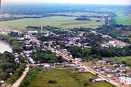
| View of San Luis de Palenque | ||
San Luis de Palenque is a municipality ( municipio ) in the department of Casanare in Colombia .
geography
San Luis de Palenque is located in the Colombian Llanos region east of the Andes , 106 km from Yopal and 446 km from Bogotá. San Luis de Palenque is located at an altitude of about 180 meters and has an average annual temperature of about 26 ° C. The entire municipality has an area of 3052 km². The Río Pauto and the Río Guanapalo , tributaries of the Río Meta, flow through the municipality . The municipality borders in the north on the Río Pauto and the municipalities of Trinidad and Pore , in the south on Orocué , in the east on the Río Meta and the Departamento de Vichada ( Santa Rosalía ) and in the west on Yopal and Nunchía .
population
The municipality of San Luis de Palenque has 7951 inhabitants, of which 2433 live in the urban part (cabecera municipal) of the municipality (as of 2019).
history
San Luis de Palenque was founded in 1953 on the banks of the Río Pauto and received the status of a municipality just a year later. The first group of settlers consisted of about 70 families who came from the Guanapalo affected by La Violencia .
economy
The main industry in San Luis de Palenque is cattle production . In addition, agriculture , mining and trade operated.
Infrastructure
San Luis de Palenque has two small airfields. There is also a paved road from Yopal. The Pauto and Guanapalo rivers are navigable.
Web links
- Alcaldia de San Luis de Palenque. Alcaldía de San Luis de Palenque - Casanare, accessed on June 5, 2019 (Spanish, website of the municipality of San Luis de Palenque).
Individual evidence
- ↑ Geography. Alcaldía de San Luis de Palenque - Casanare, accessed June 5, 2019 (Spanish, information on the geography of the municipality).
- ↑ ESTIMACIONES DE POBLACIÓN 1985 - 2005 Y PROYECCIONES DE POBLACIÓN 2005 - 2020 TOTAL DEPARTAMENTAL POR ÁREA. DANE, May 11, 2011, accessed on June 5, 2019 (Spanish, extrapolation of the population of Colombia (Excel; 1.72 MB)).
- ↑ Historia de San Luis de Palenque. Alcaldía de San Luis de Palenque - Casanare, accessed June 5, 2019 (Spanish, information on the history of the municipality).
- ↑ Economía. Alcaldía de San Luis de Palenque - Casanare, accessed June 5, 2019 (Spanish, information on the municipality's economy).
- ↑ Vías de comunicación. Alcaldía de San Luis de Palenque - Casanare, accessed on June 5, 2019 (Spanish, information on the infrastructure of the municipality).


