Rio Zulia
| Rio Zulia | ||
|
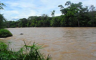
The Zulia near Santiago in the Venezuelan state of Zulia |
||
| Data | ||
| location | Colombia , Venezuela | |
| River system | Catatumbo River | |
| Drain over | Río Catatumbo → Lake Maracaibo → Caribbean Sea | |
| confluence | from Río Arboledas and Río Cucutilla 7 ° 37 ′ 39 ″ N , 72 ° 46 ′ 35 ″ W |
|
| Source height | 874 m | |
| muzzle | west of Encontrados in the Río Catatumbo Coordinates: 9 ° 3 ′ 23 " N , 72 ° 17 ′ 44" W, 9 ° 3 ′ 23 " N , 72 ° 17 ′ 44" W |
|
| Mouth height | 12 m | |
| Height difference | 862 m | |
| Bottom slope | 2.8 ‰ | |
| length | 310 km | |
| Left tributaries | Río Salazar , Río Peralonso | |
| Right tributaries | Río Grita , Río Pamplonita | |
| Communities | El Zulia , Puerto Santander , El Guayabo | |
The Río Zulia is a roughly 310 kilometers long river in northern South America.
It flows through the Colombian Departamento de Norte de Santander , passes the border to the Venezuelan state of Zulia at Puerto Santander and flows into the Río Catatumbo at Encontrados .

