Catatumbo River
|
Río Catatumbo Río Algodonal |
||
|
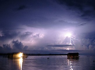
Catatumbo thunderstorm in the estuary area |
||
| Data | ||
| location | Colombia , Venezuela | |
| River system | Catatumbo River | |
| source | in the Colombian Eastern Cordillera 7 ° 52 ′ 51 ″ N , 73 ° 13 ′ 31 ″ W |
|
| Source height | approx. 2000 m | |
| muzzle | in Lake Maracaibo Coordinates: 9 ° 21 ′ 13 " N , 71 ° 42 ′ 6" W 9 ° 21 ′ 13 " N , 71 ° 42 ′ 6" W. |
|
| Mouth height | 0 m | |
| Height difference | approx. 2000 m | |
| Bottom slope | approx. 4 ‰ | |
| length | approx. 500 km | |
| Catchment area | 22,317 km² | |
| Left tributaries | Río Chiquito , Río El Brandy , Río de Oro | |
| Right tributaries | Río El Tarra , Río Orú , Río Sardinata , Río Zulia | |
| Big cities | Ocaña | |
| Communities | Algodonal , Puerto Machete , Encontrados | |
|
Location of the Río Catatumbo |
||
The Río Catatumbo is a 500 km long river in Colombia and Venezuela in northern South America.
The Río Catatumbo has its source in the Colombian Eastern Cordillera on the Cerro de las Jurisdicciones . In the upper reaches it bears the name Río Algodonal . It flows through the Colombian administrative district Departamento de Norte de Santander . The river flows north through the mountains. It flows east past the city of Ocaña . Later it turns to the northeast and finally to the east and reaches the lowlands. It crosses the border into Venezuela and flows through the Venezuelan state of Zulia , before flowing into Lake Maracaibo . At Encontrados the Río Zulia flows into the river from the right. Other important tributaries of the Río Catatumbo are Río Chiquito , Río El Brandy and Río de Oro from the left and Río El Tarra , Río Orú and Río Sardinata from the right. The Catatumbo Barí National Park in Colombia covers the area northwest of the central reaches.

