Cape Maisí: Difference between revisions
Content deleted Content added
m Reverted edits by 212.237.120.96 (talk) (HG) (3.4.9) |
Add location |
||
| Line 17: | Line 17: | ||
| mark = |
| mark = |
||
| marker_size = |
| marker_size = |
||
| location = |
| location =[[Guantanamo Province]] |
||
| coordinates = {{Coord|20|14|38.1|N|74|8|34.7|W|type:landmark|display=inline,title}} |
| coordinates = {{Coord|20|14|38.1|N|74|8|34.7|W|type:landmark|display=inline,title}} |
||
| coordinates_ref = |
| coordinates_ref = |
||
Revision as of 04:42, 3 January 2021
Cabo Maisí | |
|---|---|
| Coordinates: 20°14′38.1″N 74°8′34.7″W / 20.243917°N 74.142972°W | |
| Location | Guantanamo Province |
| Offshore water bodies | Caribbean Sea, Atlantic Ocean |
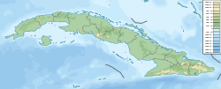
Cape Maisí or Cape Maysí is a cape at the eastern extremity of Cuba, projecting into the Windward Passage.[1] It lies in the municipality of Maisí, Guantánamo Province.
See also
Notes
- ^ Merriam-Webster's Geographical Dictionary, Third Edition, p. 691.
References
- Merriam-Webster's Geographical Dictionary, Third Edition. Springfield, Massachusetts: Merriam-Webster, Incorporated, 1997.

