Puerto Arica
Puerto Arica | |
|---|---|
Municipality and town | |
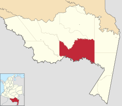
 Location of the county of Puerto Arica | |
| Coordinates: 2°8′53″S 71°45′12″W / 2.14806°S 71.75333°W | |
| Country | |
| Department | Amazonas Department |
| Elevation | 96 m (315 ft) |
| Population (2015) | |
| • Total | 1,350 |
| Time zone | UTC-5 (Colombia Standard Time) |
| Climate | Af |
Puerto Arica is a town and municipality in the Colombian Department of Amazonas.
History
Originally founded by Peruvian refugees from the War of the Pacific, it was awarded to Colombia after the Salomón-Lozano Treaty.[1]
Climate
Puerto Arica has a tropical rainforest climate (Köppen Af) with heavy to very heavy rainfall year-round.
| Climate data for Puerto Arica | |||||||||||||
|---|---|---|---|---|---|---|---|---|---|---|---|---|---|
| Month | Jan | Feb | Mar | Apr | May | Jun | Jul | Aug | Sep | Oct | Nov | Dec | Year |
| Mean daily maximum °C (°F) | 31.1 (88.0) |
31.4 (88.5) |
31.0 (87.8) |
31.4 (88.5) |
30.4 (86.7) |
29.6 (85.3) |
30.0 (86.0) |
30.6 (87.1) |
30.9 (87.6) |
30.8 (87.4) |
31.1 (88.0) |
31.6 (88.9) |
30.8 (87.5) |
| Daily mean °C (°F) | 26.5 (79.7) |
26.5 (79.7) |
26.4 (79.5) |
26.6 (79.9) |
26.2 (79.2) |
25.5 (77.9) |
25.5 (77.9) |
25.7 (78.3) |
26.2 (79.2) |
26.5 (79.7) |
27.1 (80.8) |
26.8 (80.2) |
26.3 (79.3) |
| Mean daily minimum °C (°F) | 21.9 (71.4) |
21.7 (71.1) |
21.9 (71.4) |
21.8 (71.2) |
22.1 (71.8) |
21.4 (70.5) |
21.0 (69.8) |
20.9 (69.6) |
21.5 (70.7) |
22.3 (72.1) |
23.1 (73.6) |
22.0 (71.6) |
21.8 (71.2) |
| Average rainfall mm (inches) | 269.9 (10.63) |
276.3 (10.88) |
355.9 (14.01) |
430.7 (16.96) |
254.8 (10.03) |
205.5 (8.09) |
221.8 (8.73) |
144.6 (5.69) |
159.3 (6.27) |
204.2 (8.04) |
224.6 (8.84) |
248.7 (9.79) |
2,996.3 (117.96) |
| Average rainy days (≥ 1 mm) | 13 | 12 | 16 | 16 | 16 | 16 | 14 | 12 | 10 | 13 | 13 | 15 | 166 |
| Source 1: IDEAM[2] | |||||||||||||
| Source 2: Climate-Data.org[3] | |||||||||||||
References
- ^ Porras Barrenechea, Raúl. Historia de los límites del Perú (PDF) (in Spanish). Librería Francesa Científica y Casa Editorial E. Rosay. p. 79-80. Archived from the original (PDF) on 6 de noviembre de 2014.
{{cite book}}: Check date values in:|archive-date=(help); Cite has empty unknown parameter:|fechaacceso=(help); Unknown parameter|enlaceautor=ignored (|author-link=suggested) (help) - ^ "Data". www.ideam.gov.co. Retrieved 2020-08-19.
- ^ "Climate: Puerto Arica". Climate-Data.org. Retrieved August 19, 2020.

