Girei
Girei | |
|---|---|
LGA and town | |
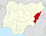
 Map of Adamawa State highlighting Girei | |
| Nickname: man geda bata bacci ko anyi ruwan sama | |
| Coordinates: 9°22′N 12°33′E / 9.367°N 12.550°E | |
| Country | |
| State | Adamawa State |
| Time zone | UTC+1 (WAT) |
 | |
Girei is a town and local government area of Adamawa State, Nigeria. It lies on the Benue River. The dominant tribe in the area are the Fulɓe or Fulani; however, a substantial number of Bwatiye also dwell in villages such as Greng, Ntabo, and Labondo within the Girei local government area. The primary occupation of the people in the area is farming and cattle rearing. Girei is also a home to Radio Gotel.
climate
In Girei, the dry season is oppressively hot and partially cloudy, and the wet season is oppressively hot and humid. The average annual temperature ranges from 62 to 102 degrees Fahrenheit, rarely falling below 56 or rising over 108.


