Hurricane Ike
This article is about Hurricane Ike, a current tropical cyclone where information can change quickly or be unreliable. The latest page updates may not reflect the most up-to-date information. |
23°12′N 57°0′W / 23.200°N 57.000°W
| |||
|---|---|---|---|
Current storm status Category 4 hurricane (1-min mean) | |||
| |||
| As of: | 11 a.m. AST September 4 (1500 UTC September 4) | ||
| Location: | 23.2°N 57.0°W ± 20 nm About 525 mi (845 km) NE of the Leeward Islands | ||
| Sustained winds: | 120 knots | 140 mph | 225 km/h (1-min mean) gusting to 150 knots | 175 mph | 280 km/h | ||
| Pressure: | 938 mbar (hPa) | 27.70 inHg | ||
| Movement: | WNW at 14 kt | 16 mph | 26 km/h | ||
| See more detailed information. | |||
Hurricane Ike is the ninth named storm, fifth hurricane and third major hurricane of the 2008 Atlantic hurricane season.[1] A Cape Verde-type hurricane, it started as a tropical disturbance off the coast of Africa near the end of August, then tracked south of Cape Verde and slowly developed. On September 1 it became a tropical storm west of the Cape Verde islands.[2][3]
Storm history

Tropical storm (39–73 mph, 63–118 km/h)
Category 1 (74–95 mph, 119–153 km/h)
Category 2 (96–110 mph, 154–177 km/h)
Category 3 (111–129 mph, 178–208 km/h)
Category 4 (130–156 mph, 209–251 km/h)
Category 5 (≥157 mph, ≥252 km/h)
Unknown
On August 29, 2008, the National Hurricane Center began tracking a tropical wave off the coast of Africa. Disorganized deep convection and moderate wind shear initially precluded tropical development.[4] By September 1 the convection had organized, demonstrating developed cyclonically curved bands and well-defined outflow,[5] warranting that the NHC declare it to be a tropical depression.[6][7] Hours later, with increasing convection and organization, the depression was upgraded to Tropical Storm Ike.[8][9][10] The storm formed and followed the path of Hurricane Hanna, which preceded it on a similar route only three days before.[11] That night the banding features on its east side eroded even as deep convection flared on the west, and the storm continued moving west, skirting south of a subtropical ridge.[12]
On the afternoon of September 3, Ike strengthened into a hurricane.[13] Rapid deepening began late that afternoon, and by early that evening, Ike strengthened into a Category 3 hurricane.[14] The eye continued to become better defined, and by late that evening, Ike strengthened into a Category 4 hurricane, and potentially reach Category 5 strength.[15]
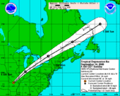
At the present time, numerical forecast models and the National Hurricane Center indicate that Ike will continue on a generally westward path, eventually reaching the Bahamas and potentially threatening Florida as a major hurricane on or around September 9th (NHC)
Current storm information
As of 11 a.m. AST September 4 (1500 UTC), Hurricane Ike is located within 20 nautical miles of 23.2°N 57.0°W, about 525 mi (845 km) northeast of the Leeward Islands. Maximum sustained winds are 120 kt (140 mph, 225 km/h), with stronger gusts. Minimum central pressure is 935 mbar (hPa, 27.70 inHg), and the system is moving west-northwest at 14 kt (16 mph, 26 km/h).
Hurricane-force winds extend out up to 45 mi (75 km) from the center of Ike, and tropical storm-force winds extend out up to 140 mi (220 km) from the center of Ike.
References
- ^ Klienberg, Eliot (2008-09-02). "U.S. tracking tropical storms Hanna, Ike, Josephine". Palm Beach Post. Retrieved 2008-09-02.
- ^ "Storm Ike, 9th of season, forms in Atlantic". Reuters. 2008-09-01. Retrieved 2008-09-01.
- ^ DiSavino, Scott (2008-09-02). "Energy market eyes Tropical Storm Ike in Atlantic". Reuters UK. Archived from the original on 2008-09-03. Retrieved 2008-09-02.
{{cite news}}: Cite has empty unknown parameter:|coauthors=(help) - ^ "Tropical Cyclone Formation Alert 291900Z AUG 08". 2008-09-01. Archived from the original on 2008-08-29. Retrieved 2008-09-01.
- ^ "Tropical Depression NINE". NOAA. 2008-09-01. Retrieved 2008-09-01.
- ^ "Tropical Depression NINE". NOAA. 2008-09-01. Retrieved 2008-09-01.
- ^ Brown, Tom (2008-09-01). "New tropical depression forms over open Atlantic". Reuters. Archived from the original on 2008-09-04. Retrieved 2008-09-01.
- ^ "Tropical Storm IKE". NOAA. 2008-09-01. Retrieved 2008-09-01.
- ^ Rappleye, Christine (2008-09-01). "Tropical Storm Ike the ninth named storm of the season". Beaumont Enterprise. Retrieved 2008-09-01.
{{cite news}}: Cite has empty unknown parameter:|coauthors=(help) - ^ Christie, Michael (2008-09-01). "Storm Ike forms, seen growing into hurricane". Reuters. Retrieved 2008-09-01.
- ^ "Tropical Storm Ike forms in Atlantic". Sun Sentinel. 2008-09-01. Retrieved 2008-09-01.
- ^ Roberts/Franklin (2008-09-01). "Tropical Storm Ike Discussion Number 3". National Hurricane Center. Retrieved 2008-09-02.
- ^ Delva, Joseph Guyler (2008-09-03). "Ike strengthens into major hurricane". Reuters. Retrieved 2008-09-03.
{{cite news}}: Unknown parameter|coauthors=ignored (|author=suggested) (help) - ^ "Forecasters: Ike strengthens into major hurricane". Associated Press. The Guardian. 2008-09-03. Retrieved 2008-09-03.
- ^ "Tropical Cyclone Formation Alert 291900Z AUG 08". 2008-09-01. Archived from the original on 2008-08-29. Retrieved 2008-09-01.
External links
For latest official information see: The NHC's archive on Hurricane Ike.
- The NHC's latest public advisory on Hurricane Ike.
- The NHC's latest forecast/advisory on Hurricane Ike.
- Webcamplaza.net hurricane 2008


