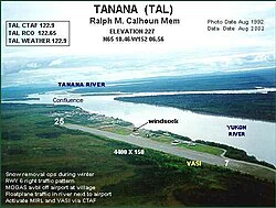
Ralph M. Calhoun Memorial Airport
Ralph M. Calhoun Memorial Airport | |||||||||||
|---|---|---|---|---|---|---|---|---|---|---|---|
 | |||||||||||
| Summary | |||||||||||
| Airport type | Public | ||||||||||
| Owner | Alaska DOT&PF - Northern Region | ||||||||||
| Serves | Tanana, Alaska | ||||||||||
| Elevation AMSL | 236 ft / 72 m | ||||||||||
| Coordinates | 65°10′28″N 152°06′34″W / 65.17444°N 152.10944°W | ||||||||||
| Runways | |||||||||||
| |||||||||||
| Statistics (2005) | |||||||||||
| |||||||||||
Ralph M. Calhoun Memorial Airport (IATA: TAL, ICAO: PATA, FAA LID: TAL) is a state-owned public-use airport located one nautical mile (1.85 km) west of the central business district of Tanana, a city in the Yukon-Koyukuk Census Area of the U.S. state of Alaska.[1]
Facilities and aircraft
Ralph M. Calhoun Memorial Airport covers an area of 1,650 acres (670 ha) at an elevation of 236 feet (72 m) above mean sea level. It has one runway designated 7/25 with a gravel surface measuring 4,400 by 150 feet (1,341 x 46 m). For the 12-month period ending December 31, 2005, the airport had 3,100 aircraft operations, an average of 258 per month: 55% general aviation, 44% air taxi and 2% military.[1]
Airlines and destinations
- Arctic Circle Air (Fairbanks) [2]
- Frontier Flying Service
- Warbelow's Air Ventures
- Wright Air Service (Fairbanks, Hughes, Huslia) [3]
References
- ^ a b c FAA Airport Form 5010 for TAL PDF, effective 2009-05-07.
- ^ Fairbanks Schedule. Arctic Circle Air. Published 24 Apr 2006.
- ^ Tanana Schedules and Fares. Wright Air Service. May 2006.
External links
- FAA Alaska airport diagram (GIF)
- FAA Terminal Procedures for TAL, effective May 16, 2024
- Resources for this airport:
- FAA airport information for TAL
- AirNav airport information for PATA
- ASN accident history for TAL
- FlightAware airport information and live flight tracker
- NOAA/NWS latest weather observations for PATA
- SkyVector aeronautical chart for TAL
