
Tīnui

Tinui is a small village approximately 40 kilometres from Masterton, in the Wairarapa, New Zealand. The name Tinui comes from the Māori words ti, meaning cabbage tree and nui, meaning many.[1] While the actual village of Tinui is small, consisting of only two streets, Charles Street and Blackhill Road, the village serves as the centre of the wider Tinui farming area, with:
- Tinui War Memorial Hall
- Tinui Primary School
- Craft Shop[2]
- Tinui General Store
- Tinui Hotel
- Anglican Church of the Good Shepherd[3]
- Volunteer Rural fire station[4]
School
Tinui Primary School is a small country school serving the entire Mangapakeha, Tinui, Annedale, Tinui Valley, Whakataki, Castlepoint and Mataikona areas. It is a decile 6 state school and has approximately 55 pupils.[5]
History
Tinui was the first place in New Zealand to have an ANZAC Day service, when the then vicar led an expedition to place a large metle cross on the Tinui Taipos, a 360 m (1200 ft) high large promontory behind the village, in April 1916 to commemorate the dead. A service was held on the 25th of April of that year.[6] In 2006 the 90th Anniversary of the event was celebrated with a full 21-gun salute fired at the service by soldiers from the Waiouru Army Camp. In 2009 the Air Force began promoting Tinui as a domestic alternative to travelling to Gallipoli. Veterans' Affairs Minister Judith Collins said of the promotion; "I would be delighted to see Tinui become a place where people come to pay their respects and remember those who have fallen."[7]
Tinui, being on the river flats next to a junction of the Whareama River and the Tinui Stream, has been flooded often; the first flood was recorded in 1858 when water covered the river flats. In 1936, floods caused thousands of sheep to drown and floodwaters reached a depth of 450mm inside the Tinui Hotel. The 1991 floods devastated the town when 200mm of rain fell over a 24 hour period, and just a year later, in July 1992 the river flooded again.[8]
-
 The Tinui Hotel
 -
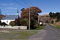 A view of The Church of the Good Shepherd
 -
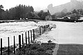 Annedale Road under water during the July 1992 flood


References
- ^ Reed, A.W. (2002) The Reed dictionary of New Zealand place names. Auckland: Reed Books. ISBN 0-790-00761-4.
- ^ wizbiz.co.nz profile
- ^ Anglican Diocese of Wellington profile
- ^ 111emergency.co.nz
- ^ Te Kete Ipurangi school profile.
- ^ Tinui war memorial, New Zealand History online - Nga korero aipurangi o Aotearoa, History Group, Ministry for Culture and Heritage, Wellington, New Zealand. Updated 20 April 2007. Accessed 19 April 2009.
- ^ Katterns, Tanya (18 April 2009). "Tiny Tinui proposed as our 'new Gallipoli'". The Dominion Post. Retrieved 23 November 2011.
- ^ Casey, C. (1996) After the rains came : The Tinui Flood of April 1991. Masterton District Library. ISBN 0-473-03793-9