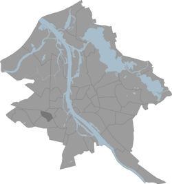
Šampēteris
Šampēteris | |
|---|---|
Neighbourhood of Riga | |
 Location of Šampēteris in Riga | |
| Country | Latvia |
| City | Riga |
| District | Zemgale Suburb |
| Area | |
| • Total | 1.366 km2 (0.527 sq mi) |
| Population (2018) | |
| • Total | 4,886 |
| • Density | 3,600/km2 (9,300/sq mi) |
| Website | apkaimes.lv |
Šampēteris is an old Riga neighbourhood on the Pārdaugava side of the Daugava river, with many houses built in the first part of 20th century still surviving.
Etymology
The area's name comes from the French word champêtre, which means 'rural, pastoral'.
56°56′31″N 24°02′23″E / 56.9419°N 24.0397°E
