Curralinho: Difference between revisions
Content deleted Content added
new |
m Added {{notability}} and {{primarysources}} tags to article. using Friendly |
||
| Line 1: | Line 1: | ||
{{notability|date=June 2009}} |
|||
{{primarysources|date=June 2009}} |
|||
{{Infobox Settlement |
{{Infobox Settlement |
||
|name = Curralinho |
|name = Curralinho |
||
Revision as of 18:11, 24 June 2009
The topic of this article may not meet Wikipedia's general notability guideline. (June 2009) |
Curralinho | |
|---|---|
Municipality | |
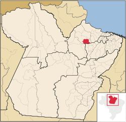
 Location in the State of Pará | |
| Country | |
| Region | North |
| State | |
| Area | |
| • Total | 3,617.240 km2 (1,396.624 sq mi) |
| Elevation | 15 m (49 ft) |
| Population (2008) | |
| • Total | 26,864 |
| • Density | 6.5/km2 (17/sq mi) |
| Time zone | UTC-3 (BST) |
| Postal Code | 68815-000 |
Curralinho is a Brazilian municipality located in the state of Pará. Its population as of 2008 is estimated to be 26,864 people. The area of the municipality is 3.617,240 km². The city belongs to the mesoregion Marajó and to the microregion of Furos de Breves.

