
Meerle
Meerle | |
|---|---|
Village | |
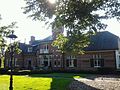
 Former town hall and clergy house | |
 Meerle Location in Belgium | |
| Coordinates: 51°28′24″N 4°48′13″E / 51.4733°N 4.8036°E | |
| Country | |
| Region | Flemish Region |
| Province | Antwerp |
| Municipality | Hoogstraten |
| Area | |
| • Total | 24.66 km2 (9.52 sq mi) |
| Population (2021)[1] | |
| • Total | 3,671 |
| • Density | 150/km2 (390/sq mi) |
| Time zone | CET |
Meerle is a village in the Belgian municipality of Hoogstraten in the province of Antwerp. As of 2021, it has about 3,871 inhabitants.[1]
History[edit]
The village was first mentioned in 1266 as Meerle, and means "open forest near a lake/pond". The Thorn Abbey used to have many possessions in Meerle, and the village originally belonged to the Land of Breda. During the 14th century, the possessions were gradually transferred to the Lord of Hoogstraten. After the French Revolution, Meerle became an independent municipality. The village was mainly an agricultural village with an emphasis on livestock. During the 20th century, it increasingly became a residential town.[2] Meerle was an independent municipality until 1977 when it was merged into Hoogstraten.[3]
Gallery[edit]
-
 Manor house Sint-Jorisburg
 -
 St Salvator Church
 -
 House in Meerle
 -
 Miller's house


References[edit]
- ^ a b c "Bevolking per statistische sector - Sector 13014D". Statistics Belgium. Retrieved 9 May 2022.
- ^ "Meerle". Agentschap Onroerend Erfgoed (in Dutch). Retrieved 9 May 2022.
- ^ "Hoogstraten". Agentschap Onroerend Erfgoed (in Dutch). Retrieved 9 May 2022.
External links[edit]
 Media related to Meerle at Wikimedia Commons
- (in Dutch) Official website of Hoogstraten
Belgian municipality Hoogstraten | |
|---|---|
| Deelgemeentes | |
This Antwerp Province location article is a stub. You can help Wikipedia by expanding it. |