Meredosia, Illinois: Difference between revisions
infobox, Geobox->Infobox (via CenPop script) |
infobox (via CenPop script) |
||
| Line 16: | Line 16: | ||
| motto = |
| motto = |
||
| anthem = |
| anthem = |
||
| image_map = File:Morgan County Illinois Incorporated and Unincorporated areas Meredosia Highlighted.svg |
|||
| image_map = |
|||
| mapsize = |
| mapsize = |
||
| map_alt = |
| map_alt = |
||
| map_caption = |
| map_caption = Location of Meredosia in Morgan County, Illinois. |
||
| image_map1 = Illinois in United States (US48).svg |
| image_map1 = Illinois in United States (US48).svg |
||
| mapsize1 = |
| mapsize1 = |
||
Revision as of 00:49, 12 July 2017
Meredosia | |
|---|---|
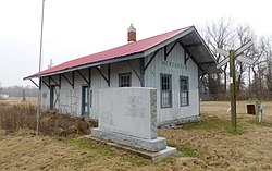
 Memorial and former train station in Meredosia | |
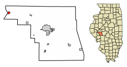
 Location of Meredosia in Morgan County, Illinois. | |
 Location of Illinois in the United States | |
| Coordinates: 39°49′48″N 90°33′30″W / 39.83000°N 90.55833°W | |
| Country | United States |
| State | Illinois |
| County | Morgan |
| Area | |
| • Total | 0.87 sq mi (2.25 km2) |
| • Land | 0.83 sq mi (2.16 km2) |
| • Water | 0.04 sq mi (0.10 km2) |
| Elevation | 443 ft (135 m) |
| Population (2010) | |
| • Total | 1,044 |
| • Estimate (2016)[2] | 1,004 |
| • Density | 1,205.28/sq mi (465.44/km2) |
| Time zone | UTC-6 (CST) |
| • Summer (DST) | UTC-5 (CDT) |
| ZIP Code(s) | 62665 |
| Area code | 217 |
| FIPS code | 17-48424 |
| Wikimedia Commons | Meredosia, Illinois |
Meredosia is a village in Morgan County, Illinois, United States. The population was 1,041 at the 2000 census. It is part of the Jacksonville Micropolitan Statistical Area.
Geography
According to the 2010 census, Meredosia has a total area of 0.867 square miles (2.25 km2), of which 0.83 square miles (2.15 km2) (or 95.73%) is land and 0.037 square miles (0.10 km2) (or 4.27%) is water.[3]
Meredosia is the home of the Meredosia National Wildlife Refuge.
Marais d'Osier, meaning willow swamp, was the original French name given to the area in the early 1800s.
Demographics
| Census | Pop. | Note | %± |
|---|---|---|---|
| 1880 | 750 | — | |
| 1890 | 621 | −17.2% | |
| 1900 | 700 | 12.7% | |
| 1910 | 951 | 35.9% | |
| 1920 | 810 | −14.8% | |
| 1930 | 820 | 1.2% | |
| 1940 | 998 | 21.7% | |
| 1950 | 940 | −5.8% | |
| 1960 | 1,034 | 10.0% | |
| 1970 | 1,178 | 13.9% | |
| 1980 | 1,272 | 8.0% | |
| 1990 | 1,134 | −10.8% | |
| 2000 | 1,041 | −8.2% | |
| 2010 | 1,044 | 0.3% | |
| 2016 (est.) | 1,004 | [2] | −3.8% |
As of the census[5] of 2000, there were 1,041 people, 450 households, and 301 families residing in the village. The population density was 1,130.3 people per square mile (436.9/km²). There were 486 housing units at an average density of 527.7 per square mile (204.0/km²). The racial makeup of the village was 99.90% White, and 0.10% from two or more races. Hispanic or Latino of any race were 0.10% of the population.
There were 450 households out of which 28.2% had children under the age of 18 living with them, 55.1% were married couples living together, 8.7% had a female householder with no husband present, and 33.1% were non-families. 30.2% of all households were made up of individuals and 16.7% had someone living alone who was 65 years of age or older. The average household size was 2.31 and the average family size was 2.85.
In the village, the population was spread out with 24.0% under the age of 18, 6.4% from 18 to 24, 25.2% from 25 to 44, 25.2% from 45 to 64, and 19.2% who were 65 years of age or older. The median age was 41 years. For every 100 females there were 97.5 males. For every 100 females age 18 and over, there were 95.3 males.
The median income for a household in the village was $32,961, and the median income for a family was $40,917. Males had a median income of $31,979 versus $16,842 for females. The per capita income for the village was $19,391. About 5.8% of families and 9.2% of the population were below the poverty line, including 11.6% of those under age 18 and 4.4% of those age 65 or over.
Notable people
- Frank Skinner, music composer for Hollywood films, was born in Meredosia.
References
- ^ "2016 U.S. Gazetteer Files". United States Census Bureau. Retrieved Jun 29, 2017.
- ^ a b "Population and Housing Unit Estimates". Retrieved June 9, 2017.
- ^ "G001 - Geographic Identifiers - 2010 Census Summary File 1". United States Census Bureau. Retrieved 2015-10-26.
- ^ "Census of Population and Housing". Census.gov. Retrieved June 4, 2015.
- ^ "American FactFinder". United States Census Bureau. Retrieved 2008-01-31.

