Paranaíba: Difference between revisions
Content deleted Content added
Dr. Blofeld (talk | contribs) No edit summary |
m Fixed typo (via WP:JWB) |
||
| (42 intermediate revisions by 29 users not shown) | |||
| Line 1: | Line 1: | ||
{{For|the river|Paranaíba River}} |
|||
{{CoorHeader|19|40|37|S|51|11|27|W|scale:30000}} |
|||
{{Infobox settlement |
|||
| ⚫ | |||
|name = Paranaíba |
|||
|settlement_type = [[municipalities of Brazil|Municipality]] |
|||
|official_name = The Municipality of Paranaíba |
|||
|nickname = |
|||
|image_skyline =Stoantonioparanaiba.JPG |
|||
|imagesize = |
|||
|image_caption = |
|||
|motto = |
|||
|image_flag =1bandeiraparanaiba.png |
|||
|image_seal = Brasão de Paranaíba (MS).jpg |
|||
|image_map = MatoGrossodoSul Municip Paranaiba.svg |
|||
|mapsize = 250px |
|||
|pushpin_map = |
|||
|map_caption = Location of Paranaíba |
|||
|subdivision_type = [[List of sovereign states|Country]] |
|||
|subdivision_type1 = [[Regions of Brazil|Region]] |
|||
|subdivision_type2 = [[States of Brazil|State]] |
|||
|subdivision_name = {{flag|Brazil}} |
|||
|subdivision_name1 = [[Center-West Region, Brazil|Central-West]] |
|||
|subdivision_name2 = [[Image:Bandeira de Mato Grosso do Sul.svg|border|22px]] [[Mato Grosso do Sul]] |
|||
|leader_title = [[Mayor]] |
|||
|leader_name = José Garcia de Freitas (Zé Braquiara) ([[Democratic Labour Party (Brazil)|PDT]]) |
|||
|established_title = Founded |
|||
|established_date = April 19, 1838 |
|||
|area_note = |
|||
|area_magnitude = |
|||
|area_total_km2 = 5402.778 |
|||
|population_note = |
|||
|population_as_of = 2020 <ref>[https://cidades.ibge.gov.br/brasil/ms/paranaiba/panorama IBGE 2020]</ref> |
|||
|population_metro = |
|||
|area_metro_km2 = |
|||
|population_total = 42,276 |
|||
|population_density_km2 = 7.16 |
|||
|timezone = [[Time in Brazil|AMT]] |
|||
|utc_offset = −4 |
|||
|timezone_DST = |
|||
|utc_offset_DST = |
|||
|elevation_m = 374 |
|||
|elevation_ft = |
|||
|coordinates = {{coord|19|40|37|S|51|11|27|W|region:BR|display=inline,title}} |
|||
|blank_name = '''[[Human Development Index|HDI]]''' (2000) |
|||
|blank_info = 0.772 – <span style="color:#fc0">medium</span><ref>[http://www.pnud.org.br/atlas/ranking/IDH-M%2091%2000%20Ranking%20decrescente%20(pelos%20dados%20de%202000).htm] - [[UNDP]]</ref> |
|||
|website = [http://www.paranaiba.ms.gov.br/ www.paranaiba.ms.gov.br/] |
|||
|footnotes = |
|||
}} |
|||
| ⚫ | |||
==References== |
==References== |
||
{{Commons category|Paranaíba}} |
|||
{{reflist}} |
|||
{{Reflist}} |
|||
{{Authority control}} |
|||
| ⚫ | |||
{{DEFAULTSORT:Paranaiba}} |
|||
[[Category: |
[[Category:Municipalities in Mato Grosso do Sul]] |
||
[[Category:Populated places established in 1838]] |
|||
[[Category:1838 establishments in Brazil]] |
|||
| ⚫ | |||
[[br:Paranaíba]] |
|||
[[es:Paranaíba (municipio)]] |
|||
[[fr:Paranaíba]] |
|||
[[bpy:পারানাইবা]] |
|||
[[it:Paranaíba]] |
|||
[[nl:Paranaíba]] |
|||
[[no:Paranaíba]] |
|||
[[pt:Paranaíba]] |
|||
[[ro:Paranaíba]] |
|||
[[vo:Paranaíba]] |
|||
Revision as of 00:24, 15 April 2024
Paranaíba | |
|---|---|
| The Municipality of Paranaíba | |
 | |
 Location of Paranaíba | |
| Coordinates: 19°40′37″S 51°11′27″W / 19.67694°S 51.19083°W | |
| Country | |
| Region | Central-West |
| State | |
| Founded | April 19, 1838 |
| Government | |
| • Mayor | José Garcia de Freitas (Zé Braquiara) (PDT) |
| Area | |
| • Total | 5,402.778 km2 (2,086.024 sq mi) |
| Elevation | 374 m (1,227 ft) |
| Population (2020 [1]) | |
| • Total | 42,276 |
| • Density | 7.16/km2 (18.5/sq mi) |
| Time zone | UTC−4 (AMT) |
| HDI (2000) | 0.772 – medium[2] |
| Website | www.paranaiba.ms.gov.br/ |
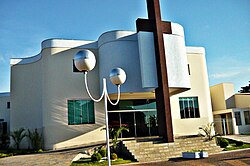
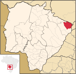
Paranaíba is the easternmost municipality in the Brazilian state of Mato Grosso do Sul. Its population was 42,276 (2020) and its area is 5,402.778 km2.
References
Wikimedia Commons has media related to Paranaíba.


