Paranaíba
| Município de Paranaíba Paranaíba |
|||
|---|---|---|---|
|
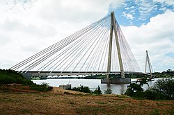
Ponte Alencastro, bridge over the Rio Paranaíba between Paraníba and Carneirinho
|
|||
|
|
|||
| Coordinates | 19 ° 41 ′ S , 51 ° 11 ′ W | ||
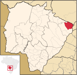
 Location of the municipality in the state of Mato Grosso do Sul Location of the municipality in the state of Mato Grosso do Sul
|
|||
| Symbols | |||
|
|||
| founding | April 12, 1838 (age 182) July 4, 1857 as Vila de Santana do Paranaíba July 13, 1894 (city rights) |
||
| Basic data | |||
| Country | Brazil | ||
| State | Mato Grosso do Sul | ||
| ISO 3166-2 | BR-MS | ||
| structure | 8 districts | ||
| height | 474 m | ||
| Waters | Rio Paranaíba | ||
| climate | tropical, Aw | ||
| surface | 5,402.7 km² | ||
| Residents | 40,192 (2010) | ||
| density | 7.4 Ew. / km² | ||
| estimate | 42,148 (July 1, 2019) | ||
| Parish code | IBGE : 5006309 | ||
| Post Code | 79500-000 | ||
| Telephone code | (+55) 67 | ||
| Time zone | UTC −4 | ||
| Website | paranaiba.ms (Brazilian Portuguese) | ||
| politics | |||
| City Prefect | Ronaldo Miziara (2017-2020) | ||
| Political party | PSDB | ||
| Culture | |||
| Patron saint | Saint Anna | ||
| economy | |||
| GDP | 1,170,898 thousand R $ 28,129 R $ per capita (2016) |
||
| HDI | 0.721 (2010) | ||
Paranaíba , officially Portuguese Município de Paranaíba , is a city in the northeast of the Brazilian state of Mato Grosso do Sul . The population was estimated as of July 1, 2019 at 42,148 inhabitants, who live in a community area of around 5402.7 km² and are called paranaibanos or paranaibenses . It is in 10th position of the state's 79 municipalities, the arithmetical population density is 7.4 people per km². The northern part of the municipality forms a border with Goiás .
geography
location
The city is 413 km from the state capital ( Campo Grande ) and 693 km from the state capital ( Brasília ). Neighboring cities are Lagoa Santa in the north, Itajá in the northeast , Carneirinho in the east, Aparecida do Taboado in the south, Inocência in the west and Cassilândia in the northwest .
Waters
The city is located in the basin of the Rio Paranaíba .
vegetation
The area is part of the Cerrados (savannah of central Brazil).
climate
The city has a tropical climate ( Aw ). In the year 1456 mm of precipitation falls. The mean annual temperature is 23.7 degrees Celsius.
traffic
In the city, the state road MS-240 and the federal road BR-497 join the federal road BR-158 . The city has an airport with the IATA code PBB.
economy
Paranaíba is strategically located at the interface between different Brazilian states (Mato Grosso do Sul, São Paulo , Minas Gerais and Goiás ). It is one of the 364 cities in Brazil with the classification as a "Center of Zone B" (Centro de Zona B) and has an impact on the economy of Inocência .
Average Income and HDI
The monthly average income in 2017 was a factor of 1.9 of the Brazilian minimum wage ( Salário mínimo ) of R $ 880.00 (converted for 2019: around 378 €). The Human Development Index (HDI) was at the high value of 0.721 in 2010.
Web links
Individual evidence
- ↑ Climate Paranaíba: Weather, average temperature, weather forecast for Paranaíba. In: de.climate-data.org. Retrieved October 31, 2019 .
- ↑ a b c Paranaíba - Panorama. In: cidades.ibge.gov.br. IBGE , accessed October 31, 2019 (Brazilian Portuguese).
- ↑ Ronaldo Miziara 45 (Prefeito). In: todapolitica.com. Eleições 2016, accessed October 31, 2019 (Brazilian Portuguese).


