Aparecida do Taboado
| Aparecida do Taboado | ||
|---|---|---|
|
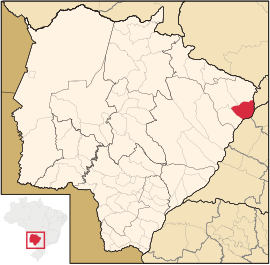
Coordinates: 20 ° 5 ′ S , 51 ° 6 ′ W Aparecida do Taboado on the map of Mato Grosso do Sul
|
||
| Basic data | ||
| Country | Brazil | |
| State | Mato Grosso do Sul | |
| City foundation | September 28, 1948 | |
| Residents | 22,621 (2010) | |
| City insignia | ||
| Detailed data | ||
| surface | 2750 km 2 | |
| Population density | 8 people / km 2 | |
| height | 292 m | |
| City structure | 3 Aparecida do Taboado (Headquarters), Cupins and Oriente | |
| Time zone | UTC −4 | |
| City Presidency | José Robson Samara Rodrigues de Almeida (PR - 22) (2013-2016) | |
| City patron | Nossa Senhora Aparecida | |
| Website | ||
| Mesoregion Central-North | ||
| Aparecida do Taboado Town Hall | ||
| Location of Aparecida do Taboado in Mato Grosso do Sul | ||
Aparecida do Taboado , officially Município de Aparecida do Taboado , is a city in the Brazilian state of Mato Grosso do Sul in the east mesoregion in the Paranaíba microregion .
geography
location
The city is 442 km from the capital of the state ( Campo Grande ) and 745 km from the state capital ( Brasília ). Neighboring cities are Inocência and Paranaíba in the north, Selvíria in the east , Santa Clara d'Oeste , Rubineia and Carneirinho in the west and Ilha Solteira in the south .
Waters
The city is located in the basin of the Rio Pardo , which flows into the Rio Paraná , which is part of the river system of the Río de la Plata . Other rivers:
- Rio Grande : a right tributary of the Rio Paraná, which rises in the state of Minas Gerais .
- Rio Paranaíba : next to the Rio Grande one of the headwaters of the Rio Paraná, which corresponds to Minas Gerais and forms the border between the states of Mato Grosso do Sul and Minas Gerais.
- Rio Pântano : right tributary of the Rio Paraná.
- Rio Quitéria : right tributary of the Rio Paraná.
vegetation
The area is part of the Cerrados (savannah of central Brazil).
climate
The city has a tropical climate . Every year, precipitation falls between 1,200 and 1,500 mm.
traffic
The BR-158 federal road and the MS-316 state road run through the city.
Average Income and HDI
The median income in 2011 was 26,506 real and the human development index (HDI) was 0.697.
Web links
Individual evidence
- ↑ IBGE : Aparecida do Taboado. Retrieved September 8, 2015 (Portuguese).
- ↑ Website of the Instituto Brasileiro de Geografia e Estatística , accessed on September 8, 2015


