Bodoquena
| Bodoquena | ||
|---|---|---|
|
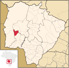
Coordinates: 20 ° 32 ′ S , 56 ° 43 ′ W Bodoquena on the map of Mato Grosso do Sul
|
||
| Basic data | ||
| Country | Brazil | |
| State | Mato Grosso do Sul | |
| City foundation | May 13, 1980 | |
| Residents | 7979 (2013) | |
| Detailed data | ||
| surface | 2507 km 2 | |
| Population density | 3 people / km 2 | |
| height | 132 m | |
| City structure | 2 districts: Bodoquena (seat), Morraria do Sul | |
| Post Code | 79390 | |
| prefix | +55 67 2551-351 | |
| Time zone | UTC −4 | |
| City Presidency | Jun Iti Hada | |
| City patron | Nossa Senhora do Perpétuo Socorro | |
| Website | ||
| Mesoregion southwest | ||
| Location of Bodoquena in Mato Grosso do Sul | ||
Bodoquena , officially Município de Bodoquena , is a city in the Pantanal in the Brazilian state of Mato Grosso do Sul in the south-west mesoregion in the Bodoquena microregion . It is on the edge of the Serra da Bodoquena National Park .
economy
The most important branch of the economy is agriculture, which generates more than 40% of the municipality's income. At 150 tons, Bodoquena has the highest passion fruit production in Mato Grosso do Sul.
Web links
Individual evidence
- ↑ IBGE : Cidades @: Bodoquena. Retrieved July 28, 2014 (Portuguese).
- ↑ Economic data Bodoquena ( Memento of the original of August 8, 2014 in the Internet Archive ) Info: The archive link was automatically inserted and not yet checked. Please check the original and archive link according to the instructions and then remove this notice. , accessed August 2, 2014


