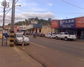
Camapuã
| Camapuã | ||
|---|---|---|
|
Coordinates: 19 ° 32 ′ S , 54 ° 3 ′ W Camapuã on the map of Mato Grosso do Sul
|
||
| Basic data | ||
| Country | Brazil | |
| State | Mato Grosso do Sul | |
| City foundation | September 30, 1948 | |
| Residents | 13,616 (2010) | |
| City insignia | ||
| Detailed data | ||
| surface | 6.230 km 2 | |
| Population density | 2.186 inhabitants / km 2 | |
| height | 409 m | |
| City structure | 3 Camapuã (Headquarters), Ponte do Rio Verde and Pontinha do Coxo | |
| Time zone | UTC −4 | |
| City Presidency | Marcelo Duailibi (DEM)
(2009–2012) |
|
| City patron | Nossa Senhora Aparecida | |
| Website | ||
| Mesoregion Central-North | ||
| Rua Petro Celestino | ||
| Location of Camapuã in Mato Grosso do Sul | ||
Camapuã , officially Município de Camapuã , is a city in the Brazilian state of Mato Grosso do Sul in the Mesoregion Central-Nord in the microregion Alto Taquari .
geography
location
The city is 137 km from the state capital ( Campo Grande ) and 997 km from the state capital ( Brasília ).
Waters
The city is under the influence of the Rio Paraná , which is part of the river system of the Río de la Plata .
vegetation
The area is part of the Cerrados (savannah of central Brazil).
climate
The city has a tropical climate (AW). The average temperature of the coldest month (June) is 27 ° C during the day and 16 ° C at night. Between November and March, the night temperature is 21 ° C and an average of 31 ° C during the day.
traffic
The BR-060 federal road runs through the city.
Average Income and HDI
The median income in 2011 was 19,248 real and the human development index (HDI) was 0.703.
Web links
Individual evidence
- ↑ IBGE : Cidades @: Camapuã. Retrieved June 24, 2015 (Portuguese).
- ↑ Clima: Camapuã: Climograma, Temperatura e Tabela climática Camapuã. In: climate-data.org. Retrieved April 3, 2018 .
- ↑ Web presence of the Instituto Brasileiro de Geografia e Estatística , accessed on June 23, 2015


