Dourados
| Município de Dourados Dourados |
|||
|---|---|---|---|
|
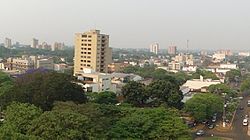
View of the center of Dourado
|
|||
|
|
|||
| Coordinates | 22 ° 14 ′ S , 54 ° 48 ′ W | ||
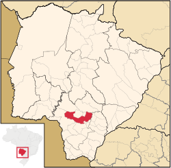
 Location of Dourados in the state of Mato Grosso do Sul Location of Dourados in the state of Mato Grosso do Sul
|
|||
| Symbols | |||
|
|||
|
Motto "Terra de Antônio João" |
|||
| founding | December 20, 1935 (city status) | ||
| Basic data | |||
| Country | Brazil | ||
| State | Mato Grosso do Sul | ||
| ISO 3166-2 | BR-MS | ||
| Mesoregion | Sudoeste de Mato Grosso do Sul (1989-2017) | ||
| Microregion | Dourados (1989-2017) | ||
| structure | 10 districts, Dourados: 170 bairros | ||
| height | 430 m | ||
| Waters | Rio Dourados | ||
| climate | Aw, tropical | ||
| surface | 4,086.4 km² | ||
| Residents | 196,035 (2010) | ||
| density | 48 Ew. / km² | ||
| estimate | 222,949 (July 1, 2019) | ||
| Parish code | IBGE : 5003702 | ||
| Post Code | 79800-000 to 79849-999 | ||
| Time zone | UTC −4 | ||
| Website | dourados.ms (Brazilian Portuguese) | ||
| politics | |||
| City Prefect | Délia Razuk (2017-2020) | ||
| Political party | PR | ||
| Culture | |||
| Patron saint | Nossa Senhora da Imaculada Conceição ( Maria ) | ||
| City festival | December 20 (city foundation) | ||
| economy | |||
| GDP | 7,284,223 thousand R $ 34,219 R $ per capita (2015) |
||
| HDI | 0.747 (2010) | ||
Dourados , officially Portuguese Município de Dourados , is the second largest city in the Brazilian state of Mato Grosso do Sul and is located 225 km southwest of the capital Campo Grande . According to an estimate of July 1, 2019, the population was 222,949.
geography
The city of Dourados is located in the south of the central-west region of Brazil, in the south-west mesoregion of the state of Mato Grosso do Sul .
The border with Paraguay is only 120 km from the city . The capital of Mato Grosso de Sol, Campo Grande , is about 235 km air distance, twice as far away.
The city takes its name from the Rio Dourados , which passes the city and flows into the Río Paraná . The Maracaju Mountains are also nearby .
climate
The following climate data are based on measurements by the Instituto Nacional de Meteorologia , which were made from 1961 to 1990. In Dourados there is a tropical climate, the coldest months are June and July with an average temperature of around 18 ° C and an average humidity of 66 to 82% all year round. There are practically no temperatures below zero in Dourados; only in the months of July and August were temperatures below zero recorded in a measurement period between 1971 and 2000. A real record year was 1981, when the absolute minus record was first recorded on July 20 at −1.7 ° C and two months later the temperature record of the measurement period was recorded at 38.5 ° C on September 28.
|
Average monthly temperatures and rainfall for Dourados
|
|||||||||||||||||||||||||||||||||||||||||||||||||||||||||||||||||||||||||||||||||||||||||||||||||||||||||||||||||||||||||||||||||||||||||||||||||||||||||||||||||||||||||||||||||||||||||||||||||||||||||||||||||||||||||||||||||||||
Neighboring places
The municipality of Dourados borders on the following municipalities, with localities in the west and south being around 50 to 100 km away:
|
Itaporã maracaju |
Douradina Rio Brilhante |
|
| Ponta Porã (over 100 km away) |

|
Deodápolis |
| Laguna Carapã | Caarapó | Fatima do Sul |
history
Before it was settled by the western world, Dourados was populated by the Terena and Guaraní-Kaiowá tribes .
On May 10, 1861, in the run-up to the Triple Alliance War, a military colony was founded in Dourados to protect Brazil against the nearby Paraguay. Towards the end of the 19th century, the first civil, western settlers also advanced into the region. At that time there was a farm owned by Marcelino Pires, who ran cattle in the region, in the area of today's city of Dourados.
The actual establishment of the young community of Dourados took place on December 20, 1935 with the decree No. 30 of the then State Governor Mário Corrêa da Costa , the land for this was reserved as early as 1923. The first Dourados council house was built in 1936. In the beginning, not only Brazilians but also Japanese people moved to the city to grow coffee in the area. Filinto Müller built his first mill in the 1940s, making it possible to supply the population with electricity until the city was connected to the power grid, although initially only for a few hours a day. From 1943 to 1946 Dourados belonged to the separate border area of Ponta Porã , which was created on September 13, 1943 with Legislative Decree 5812, but already repealed with the Constitution of 1946 , so that Dourados again belonged to the state of Mato Grosso . The city only got its own water supply with treated water at the end of the 1960s. In the following decades, Dourados developed rapidly and became the regional center in the south of the state of Mato Grosso. After doubling its population in just a decade, Dourados reached 100,000 for the first time in 1980.
On September 1, 2010, the city made international headlines after the entire political leadership of the city was arrested in an action by the Brazilian federal police : the incumbent mayor, Ari Artuzi , the deputy mayor, the council president and 26 other people were arrested for corruption . The mayor is said to have financed a breast augmentation for his wife from taxpayers' money. The year before, 40 people were arrested in the city in a large-scale operation for corruption.
population
Since the city was founded, the population has grown rapidly. According to the 2000 census of the Brazilian Institute of Geography and Statistics , 98.04% of the population of Dourado is Christian. Of these, Catholics and Orthodox make up 58.62%, compared with 29.4% Protestants and 10.78% Christians of other faiths.
| year | 1940 | 1950 | 1960 | 1970 | 1980 | 1991 | 1996 | 2000 | 2005 | 2010 | 2019 |
|---|---|---|---|---|---|---|---|---|---|---|---|
| Residents | 14,985 | 22,834 | 84,955 | 79.186 | 106,483 | 135.984 | 153.191 | 164,700 | 183.096 | 196.068 | 222,949 |
2019: IBGE estimate
politics
The municipality's legislature consists of only 19 council members, who are, however, made up of ten different parties. The current Council President is Daniella Hall (as of September 2017) of the Partido Social Democrático (PSD).
The current city prefect (mayor) of the city and thus head of the executive is Délia Godoy Razuk . She has represented the Partido da República (PR) since 2015 .
economy
The most important industries around the city are agriculture (especially soya, corn and sugar cane ) and cattle breeding . The city is the economic and social center of a region of almost one million people and supplies 30 surrounding cities, some of them in Paraguay (link to Mercosur ).
Around half of the city's employees work in the service sector, in which around 4,500 companies operate. Of 56,560 employees registered on January 1, 2017, 28,477 worked in the service sector , 14,423 in trade , 9,562 in the processing industry, 2,026 in agriculture and 1,826 in the construction sector. There are around 3,000 hotel beds in the city.
Educational institutions
In 2016 there were 133 educational institutions in Dourados, 112 of them in urban areas. 23 schools were state-run, 79 were municipal, and there were 30 private schools.
Nonetheless, around 14.2% of children aged 7 to 14 did not attend school in 2010, a figure compared to 2010 when 9.6% did not attend school. However, the proportion of children between the ages of 15 and 17 attending high school has improved. In 1990 this proportion was still 17.8%, but had improved to 42.5% of students by 2010.
- Universities
There are five universities in Dourados:
- Universidade Estadual de Mato Grosso do Sul (UEMS)
- Universidade Federal da Grande Dourados (UFGD)
- Centro Universitário da Grande Dourados (UNIGRAN)
- Faculdades da Annexuera (UNIDERP)
- Universidade Paulista (UNIP - Interativa)
Diocese of Dourados
In 1957 the Roman Catholic diocese of Dourados was founded from part of the diocese of Corumbá . Bishop Henrique Aparecido De Lima has presided over the diocese since 2015 .
traffic
Matos Pereira Airport is 14 kilometers from downtown Dourados . Around 100,000 passengers were handled at the airport in 2015.
The city is also located on the BR-163 motorway that runs through Brazil from north to south and crosses the city. The federal roads BR-376 and BR-463 and Dourados continue to Santa Cantarina (BR-376) and Pedro Juan Caballero in the northeast of Paraquay.
Sports
The two football clubs Ubiratan Esporte Clube and Clube Desportivo Sete de Setembro are based in the city. Both play their games in the 30,000-seat Estádio Fredis Saldívar , usually just called Douradão . The city also has a second larger football stadium, the Napoleão de Souza Stadium , which can seat 10,000 spectators.
Twin cities
Daughters and sons of the city
- Emmanuel Marinho , poet, actor and educator
- Daniela Albuquerque (* 1982), TV presenter, actress and former model
- Thiago Machado Mattos (Thiaguinho, * 1984), football player
- Vinicius Rodrigo Pinto Teló (born 1985), basketball player
- Magno Nazaret (* 1986), racing cyclist
- Lucas Pezzini Leiva (* 1987), football player
- Keirrison de Souza Carneiro (* 1988), football player
- Mário Lúcio da Silva Júnior (* 1989), football player
Web links
- City Prefecture website , Prefeitura Municipal (Brazilian Portuguese)
- City Council website , Câmara Municipal (Brazilian Portuguese)
Individual evidence
- ↑ a b c IBGE : Cidades @ Mato Grosso do Sul: Dourados - Panorama. Retrieved July 4, 2019 (Brazilian Portuguese).
- ↑ BDMEP - Série Histórica - Dados Diários - Temperatura Mínima (° C) - Dourados. (No longer available online.) In: Banco de Dados Meteorológicos para Ensino e Pesquisa. Instituto Nacional de Meteorologia, formerly in the original ; accessed on December 23, 2015 . ( Page no longer available , search in web archives )
- ↑ BDMEP - Série Histórica - Dados Diários - Temperatura Máxima (° C) - Dourados. (No longer available online.) In: Banco de Dados Meteorológicos para Ensino e Pesquisa. Instituto Nacional de Meteorologia, formerly in the original ; accessed on December 23, 2015 . ( Page no longer available , search in web archives )
- ^ Temperatura Média Compensada (° C) (1961-1990). Instituto Nacional de Meteorologia, accessed September 2, 2017 .
- ↑ Temperatura Máxima (° C) (1961-1990). Instituto Nacional de Meteorologia, accessed September 2, 2017 .
- ↑ Temperatura Mínima (° C) (1961-1990). Instituto Nacional de Meteorologia, accessed September 2, 2017 .
- ↑ Precipitação Acumulada Mensal e Anual (mm) (1961-1990). Instituto Nacional de Meteorologia, accessed September 2, 2017 .
- ^ Número de Dias com Precipitação Maior or Igual a 1 mm (dias). Instituto Nacional de Meteorologia, accessed September 2, 2017 .
- ↑ Insolação Total (horas). Instituto Nacional de Meteorologia, accessed September 2, 2017 .
- ↑ Umidade relativa do Ar Média Compensada (%). Instituto Nacional de Meteorologia, accessed September 2, 2017 .
- ↑ Guarani Kaiowá , website Povos Indígenas no Brasil , Instituto Socioambiental. Retrieved September 2, 2017 (English, Portuguese).
- ↑ Reserva Indígenas Dourados , website Terras Indígenas no Brasil . Retrieved September 2, 2017 (Portuguese).
- ↑ Síntese Histórica. Dourados Prefeitura, accessed September 2, 2017 (Brazilian Portuguese).
- ↑ Helio de Freitas: Em ruínas, reforma de Usina Velha que iluminava a cidade not sai do papel. In: Campo Grande News. December 9, 2012, Retrieved September 2, 2017 (Brazilian Portuguese).
- ↑ Maria José Martinelli Silva Calixto: O processo de expansão territorial urbana e seus desdobramentos socioespaciais . Ed .: Universidade Federal de Mato Grosso do Sul. (Brazilian Portuguese, observatoriogeograficoamericalatina.org.mx [PDF; 163 kB ; accessed on September 2, 2017]).
- ↑ The entire city tip goes to jail. In: Spiegel Online . September 2, 2010, accessed September 2, 2017 .
- ↑ Tabela 2094 - População resident por cor ou raça e religião. In: Census 2000. Instituto Brasileiro de Geografia e Estatística, accessed September 2, 2017 (Brazilian Portuguese).
- ↑ Mesa diretora. Câmara Municipal Dourados, accessed September 2, 2017 (Brazilian Portuguese).
- ↑ Délia Razuk , site Eleições 2016. Retrieved on September 2, 2017 (Portuguese).
- ↑ Dourados. In: CAGED - Perfil do Município. Ministério do Trabalho e Emprego , accessed September 2, 2017 (Brazilian Portuguese).
- ↑ Novos investimentos em hotéis refletem crescimento. (No longer available online.) In: Douranews. March 13, 2014, archived from the original on September 12, 2014 ; Retrieved September 2, 2017 (Brazilian Portuguese). Info: The archive link was inserted automatically and has not yet been checked. Please check the original and archive link according to the instructions and then remove this notice.
- ↑ Novos investimentos em hotéis refletem crescimento. ( MS Excel ; 257 KB) Governo de Estado Matto Grosso do Sul, accessed September 2, 2017 (Brazilian Portuguese).
- ^ Dourados - MS. Relatórios Dinâmicos, accessed September 2, 2017 (Brazilian Portuguese).
- ^ Entry on Dourados on catholic-hierarchy.org
- ↑ Aeroporto de Dourados movimenta 100 mil passageiros em 2015. In: Journal Agora MS. January 13, 2016. Retrieved September 2, 2017 (Brazilian Portuguese).


