São Gabriel do Oeste
| Município de São Gabriel do Oeste "Capital do leite"
São Gabriel do Oeste
"Capital da suinocultura" "SGO" |
|||
|---|---|---|---|
|
|
|||
| Coordinates | 19 ° 24 ′ S , 54 ° 34 ′ W | ||
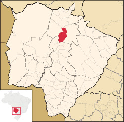
 Location of the municipality in the state of Mato Grosso do Sul Location of the municipality in the state of Mato Grosso do Sul
|
|||
| Symbols | |||
|
|||
| founding | 12th May 1980 (age 40) | ||
| Basic data | |||
| Country | Brazil | ||
| State | Mato Grosso do Sul | ||
| ISO 3166-2 | BR-MS | ||
| structure | 3 districts (since 1983) | ||
| height | 658 m | ||
| climate | tropical mountain climate, Cwa | ||
| surface | 3,864.7 km² | ||
| Residents | 22,203 (2010) | ||
| density | 5.7 Ew. / km² | ||
| estimate | 26,771 (July 1, 2019) | ||
| Parish code | IBGE : 5007695 | ||
| Post Code | 79490-000 | ||
| Telephone code | (+55) 67 | ||
| Time zone | UTC −4 | ||
| Website | www.saogabriel.ms.gov.br (Brazilian Portuguese) | ||
| politics | |||
| City Prefect | Jeferson Tomazoni (2017-2020) | ||
| Political party | MDB | ||
| Culture | |||
| Patron saint | Archangel Gabriel | ||
| economy | |||
| GDP | 1,546,040 thousand R $ 60,765 R $ per person (2017) |
||
| HDI | 0.729 (high) (2010) | ||
São Gabriel do Oeste , officially Portuguese Município de São Gabriel do Oeste , is a city in the Brazilian state of Mato Grosso do Sul . As of July 1, 2019, the population was estimated at 26,771 inhabitants, who live in a community area of around 3864.7 km² and are called São Gabrielese ( são-gabrielenses ). The population density is a low 5.7 people per km². It ranks 22nd out of 79 municipalities in the state.
geography
location
The city is 137 km from the state capital ( Campo Grande ) and 997 km from the state capital ( Brasília ). Neighboring cities are Rio Verde de Mato Grosso , Camapuã , Rio Negro and Bandeirantes .
Waters
The city is under the influence of the Rio Paraná , which is part of the river system of the Río de la Plata . The main rivers are:
- Rio Aquidauana : right tributary of the Rio Miranda . Corresponds to the Serra de Maracaju . Larger parts of the river are in the Pantanal .
- Rio Coxim : left tributary of the Rio Taquari .
- Rio Jauru : right tributary of the Rio Coxim.
- Rio Novo : left tributary of the Rio Coxim.
vegetation
The area is part of the Cerrados biome (savannah of central Brazil).
climate
In the city tropical mountain climate prevails Cwa according to the climate classification by Köppen and Geiger . The average temperature is 23.3 ° C, the average annual rainfall is 1507 mm.
traffic
In the city the state road MS-430 joins the federal road BR-163 .
economy
São Gabriel do Oeste is the largest producer of pigs and ostriches in the state of Mato Grosso do Sul. The city is also the state's largest soy producer . In addition, the place is the leading producer of sorghum in Brazil
Average Income and HDI
In 2017, the average monthly income was 2.5 times the Brazilian minimum wage ( Salário mínimo ) of R $ 880.00 (converted for 2019: around € 479). The Human Development Index (HDI) is rated high at 0.729 for 2010.
The gross national product per capita in 2016 was R $ 60,764.83.
Web links
- City Prefecture website , Prefeitura Municipal (Brazilian Portuguese)
- City Council website , Câmara Municipal (Brazilian Portuguese)
Individual evidence
- ↑ a b São Gabriel do Oeste climate: average temperature, weather by month, São Gabriel do Oeste weather averages. In: de.climate-data.org. Retrieved October 29, 2019 .
- ↑ a b c São Gabriel do Oeste - Panorama. In: cidades.ibge.gov.br. IBGE , accessed October 29, 2019 (Brazilian Portuguese).
- ↑ Jeferson Tomazoni 15 (Prefeito). In: todapolitica.com. Eleições 2016, accessed October 29, 2019 (Brazilian Portuguese).


