Rio Brilhante
| Município de Rio Brilhante Rio Brilhante |
|||
|---|---|---|---|
|
|
|||
| Coordinates | 21 ° 48 ′ S , 54 ° 33 ′ W | ||
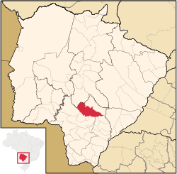
 Location of the municipality in the state of Mato Grosso do Sul Location of the municipality in the state of Mato Grosso do Sul
|
|||
| Symbols | |||
|
|||
| founding | 26th September 1929 (age 90) | ||
| Basic data | |||
| Country | Brazil | ||
| State | Mato Grosso do Sul | ||
| ISO 3166-2 | BR-MS | ||
| structure | 2 districts (Rio Brilhante (headquarters), Prudêncio Thomaz) | ||
| height | 312 m | ||
| climate | tropical, Aw | ||
| surface | 3,987.4 km² | ||
| Residents | 30,663 (2010) | ||
| density | 7.7 Ew. / km² | ||
| estimate | 37,514 (July 1, 2019) | ||
| Parish code | IBGE : 5007208 | ||
| Post Code | 79130-000 | ||
| Telephone code | (+55) 67 | ||
| Time zone | UTC −4 | ||
| Website | riobrilhante.ms.gov.br (Brazilian Portuguese) | ||
| politics | |||
| City Prefect | Donato Lopes (2017-2020) | ||
| Political party | PSDB | ||
| Culture | |||
| Patron saint | Holy Spirit | ||
| City festival | September 26th (founding day) | ||
| economy | |||
| GDP | 2,202,890 thousand. R $ 62,114 R $ per capita (2016) |
||
| HDI | 0.715 (high) (2010) | ||
Rio Brilhante , officially Portuguese Município de Rio Brilhante , is a city in the Brazilian state of Mato Grosso do Sul . The population was estimated on July 1, 2019 at 37,514 inhabitants, who live on a municipality area of around 3987.4 km² and are called Rio-Brilhantenser ( rio-brilhantenses ). The parish ranks 14th out of 79 municipalities in the state.
history
Gabriel Francisco Lopes was the first to cross the Vacaria countryside in 1841. There he found 60 cows and a bull that had been left behind by the Jesuits. He brought his father Antonio Gonçalves Barbosa with him and they named the area between the Rio Brilhante and Rio Vacaria rivers where they settled Boa Vista. The two were the first settlers after the Spaniards withdrew.
geography
location
The city is 150 km from the capital of the state ( Campo Grande ) and 1184 km from the state capital ( Brasília ). The city borders the neighboring towns of Nova Alvorada do Sul (north), Angélica (southeast), Deodápolis (south), Dourados (south), Douradina (south), Itaporã (southwest), Maracaju (west) and Sidrolândia (northwest).
climate
The city has a tropical climate ( AW ) with dry winters and humid, hot summers. The average annual temperature is 20 ° C.
| month | Jan | Feb | Mar | Apr | May | Jun | Jul | Aug | Sep | Oct | Nov | Dec |
|---|---|---|---|---|---|---|---|---|---|---|---|---|
| Average Maximum ° C | 30.3 | 30.4 | 30.4 | 28.8 | 26.2 | 24.6 | 25.3 | 27.4 | 27.7 | 29.6 | 30.3 | 29.8 |
| Average Minimum ° C | 20.3 | 20.1 | 19th | 18.5 | 16 | 13.1 | 11.7 | 13.9 | 15.4 | 17.6 | 18.8 | 18.5 |
| Average Precipitation (mm) | 203.3 | 177.9 | 139.8 | 105.5 | 102.9 | 65.4 | 45.5 | 42.8 | 79.3 | 166.6 | 150.5 | 191.9 |
Waters
The city lies on the Rio Brilhante , which belongs to the river system of the Río de la Plata .
traffic
The BR-163 federal road passes the community. The BR-267 federal road joins it in the north and the MS-378 state road in the south . Rio Bilhante has an airport with the ICAO code SSRB .
vegetation
The area is part of the Cerrados (savannah of central Brazil).
economy
The most important branch of the economy is agriculture. Rio Brilhante produces 5.7 million tons of sugar cane with a value of 337 million real on approx. 80,000 hectares .
Average Income and HDI
The monthly average income in 2017 was a factor of 2.9 of the Brazilian minimum wage ( Salário mínimo ) of R $ 880.00 (converted for 2019: around € 577). The Human Development Index (HDI) is rated high at 0.715 for 2010.
The gross national product per capita was R $ 62,114.47 in 2016.
Personalities
- Ruben Figueiró de Oliveira (* 1931), politician born in Rio Brilhante, Senator of Mato Grosso do Sul.
- Londres Machado (* 1942), politician born in Rio Brilhante
- Sebastião Assis de Figueiredo (1949–2007): Franciscan, rector and professor in the Franciscan Seminary of Rio Brilhante
- Alex Dias de Almeida (* 1972), soccer player born in Rio Brilhante
- Marcos Gomes de Araujo (* 1976), football player born in Rio Brilhante
Web links
- Prefecture website , Prefeitura Municipal (Brazilian Portuguese)
- City Council website , Câmara Municipal (Brazilian Portuguese)
- City map of Rio Brilhante
Individual evidence
- ↑ Climate Rio Brilhante: Weather, average temperature, weather forecast for Rio Brilhante. In: de.climate-data.org. Retrieved October 31, 2019 .
- ↑ a b c Rio Brilhante - Panorama. In: cidades.ibge.gov.br. IBGE , accessed October 31, 2019 (Brazilian Portuguese).
- ^ Donato 45 (Prefeito). In: todapolitica.com. Eleições 2016, accessed October 31, 2019 (Brazilian Portuguese).
- ↑ IBGE: Mato Grosso do Sul → Rio Brilhante → municipal agricultural production - temporary crops - 2012.


