Nioaque
| Nioaque | ||
|---|---|---|
|
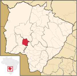
Coordinates: 21 ° 8 ′ S , 55 ° 50 ′ W Nioaque on the map of Mato Grosso do Sul
|
||
| Basic data | ||
| Country | Brazil | |
| State | Mato Grosso do Sul | |
| City foundation | May 22, 1848 | |
| Residents | 14,338 (2011) | |
| City insignia | ||
| Detailed data | ||
| surface | 3923 km 2 | |
| Population density | 4 people / km 2 | |
| height | 276 m | |
| Time zone | UTC −4 | |
| City Presidency | Gerson Garcia Serpa (PSB) (2013-2016) | |
| City patron | Santa Rita de Cássia | |
| Mesoregion southwest | ||
| Location of Nionaque in Mato Grosso do Sul | ||
Nioaque , officially Município de Nioaque , is a city in the Brazilian state of Mato Grosso do Sul in the south-west mesoregion in the Bodoquena microregion . It is on the edge of the Serra da Bodoquena National Park .
geography
location
The city is 180 km from the capital of the state ( Campo Grande ) and 1205 km from the state capital ( Brasília ).
climate
The city has a dry, tropical rainy climate ( AW ).
history
Originally written Nioac , a word from the Tupí-Guaraní languages , the Vila de Nioac , located on the Rio Nioaque and founded either on April 22 or May 22, 1848, was renamed Nioaque. In the Mato Grosso campaign , the place was conquered by Paraguayan troops.
fauna
The tarantula species Nhandu carapoensis occurs in the city .
economy
GDP per capita and HDI
The gross national product per capita (GDP) was 16,181.75 real in 2015 , the human development index (HDI) in 2010 was 0.675. The average income is 1.8 times the monthly minimum wage.
religion
About 62% of the population are Roman Catholic , another 28% Protestant .
Web links
Individual evidence
- ↑ IBGE : Cidades @: Nioaque. Retrieved September 14, 2014 (Portuguese).
- ↑ IBGE: Histórico Nioaque Mato Grosso do Sul. Retrieved September 15, 2014 (Portuguese).
- ↑ IBGE website , accessed on October 27, 2018.
- ↑ IBGE , accessed on September 16, 2014


