Cassilândia
| Cassilândia | ||
|---|---|---|
|
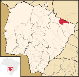
Coordinates: 19 ° 7 ′ S , 51 ° 44 ′ W Cassilândia on the map of Mato Grosso do Sul
|
||
| Basic data | ||
| Country | Brazil | |
| State | Mato Grosso do Sul | |
| City foundation | 3rd August 1954 | |
| Residents | 21,557 (2014) | |
| City insignia | ||
| Detailed data | ||
| surface | 3649 km 2 | |
| Population density | 6 people / km 2 | |
| height | 470 m | |
| City structure | 2 (Cassilândia (seat) and Indaiá do Sul) | |
| Waters | Rio Aporé | |
| Post Code | 5002902 | |
| Time zone | UTC −4 | |
| City Presidency | Carlos Augusto da Silva (DEM) (2009-2012) | |
| City patron | São José | |
| Website | ||
Cassilândia , officially Município de Cassilândia , is a Brazilian city in the state of Mato Grosso do Sul in the Mesoregion East and Microregion Cassilandia . She is also called the princess in the valley of the Rio Aporé and the city of smiles.
geography
location
The city is located on the northeastern edge of Mato Grosso do Sul and is 434 km from the capital of the state ( Campo Grande ) and 652 km from the federal capital ( Brasília ).
climate
The city has a dry, tropical rainy climate ( AW ).
Waters
The city is located in the valley of the Rio Aporé in the basin of the Río de la Plata .
vegetation
The area is part of the Cerrados (savannah of central Brazil).
traffic
Air traffic
The city has an airport with the IATA code CSS.
Web links
Commons : Cassilândia - collection of images, videos and audio files
Individual evidence
- ^ IBGE : Cidades @: Cassilândia. Retrieved September 2, 2014 (Portuguese).


