Anaurilândia
| Anaurilândia | ||
|---|---|---|
|
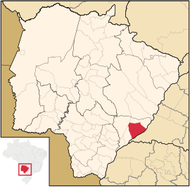
Coordinates: 22 ° 11 ′ S , 52 ° 43 ′ W Anaurilândia on the map of Mato Grosso do Sul
|
||
| Basic data | ||
| Country | Brazil | |
| State | Mato Grosso do Sul | |
| City foundation | November 11, 1963 | |
| Residents | 8534 (2010) | |
| City insignia | ||
| Detailed data | ||
| surface | 3396 km 2 | |
| Population density | 3 people / km 2 | |
| height | 312 m | |
| City structure | 2 Anaurilândia (seat) and Quebracho | |
| Post Code | 79770 | |
| prefix | +55 67445 | |
| Time zone | UTC −4 | |
| City Presidency | Vagner Alves Guirado (PR) (2013-2016) | |
| City patron | São João Batista | |
| Website | ||
| Mesoregion Central-North | ||
| Location of Anaurilândia in Mato Grosso do Sul | ||
Anaurilândia , officially Município de Anaurilândia , is a city in the Brazilian state of Mato Grosso do Sul in the mesoregion east in the microregion Nova Andradina .
history
The founder of the city was Ciriaco Gonzales. He came to the area in 1916 with Major Cecilio Manoel da Costa Lima. Gonzales acquired on January 19, 1940 5870 hectares of an area called Klarwasser (Água Clara). At that time, the indigenous plant yerba mate was grown in what is now the urban area .
Surname
The city founder was married to Anaurelíssia Gonzales. The name of the city is derived from the first name of the founder's wife, Dona Anaurelíssia Gonzales.
geography
location
The city is 372 km from the capital of the state ( Campo Grande ) and 1067 km from the state capital ( Brasília ). Neighboring cities are Bataguassu , Batayporã , Nova Andradina and Rosana .
Waters
The city is under the influence of the Rio Paraná , which is part of the river system of the Río de la Plata . Further rivers:
- Rio Baía : right tributary of the Rio Paraná.
- Rio Quiterói : right tributary of the Rio Paraná.
vegetation
The area is part of the Cerrados (savannah of central Brazil).
climate
The city has a tropical climate (Aw).
traffic
The state road MS-276 ends in the city and continues as state road MS-395 .
Average Income and HDI
The median income in 2011 was 14,696 real and the human development index (HDI) was 0.670.
Web links
Individual evidence
- ↑ IBGE : Anaurilândia. Retrieved September 6, 2015 (Portuguese).
- ↑ Web presence of the Instituto Brasileiro de Geografia e Estatística , accessed on September 6, 2015


