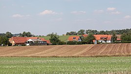
Eckersdorf (Seßlach)
|
Eckersdorf
City of Sesslach
Coordinates: 50 ° 10 ′ 26 ″ N , 10 ° 50 ′ 59 ″ E
|
|
|---|---|
| Height : | 275 m above sea level NN |
| Residents : | 25 (Jul 2, 2015) |
| Postal code : | 96145 |
| Area code : | 09569 |
|
Eckersdorf
|
|
Eckersdorf is a district of the Upper Franconian town of Seßlach in the Coburg district .
geography
Eckersdorf is about 13 kilometers southwest of Coburg on a slope above the Rodach . The state road 2204 from Seßlach to Kaltenbrunn leads past the place.
history
The first documentary mention was in 1290, when the Würzburg bishop Manegold, among other things, pledged the tithe in "Eckehartsdorf" to Karl von Heldritt . The next mention followed in 1317. During the Thirty Years War , the place on the Geyersberg was destroyed. In 1936, today's hamlet was built south of the deserted settlement as a new settlement. Five farmers from the Rhön , who were relocated due to the construction of the Wildflecken military training area , were given new farms, each with around ten hectares of agricultural land. The land came from the dissolution of the Wiesener Schlossgut, which comprised 144.8 hectares in the districts of Heilgersdorf and Seßlach.
In 1950 Eckersdorf had 29 residents and 5 residential buildings. In 1987, 22 people lived in 5 houses in the settlement. Eckersdorf has belonged to Seßlach since it was re-established.
Population development
|
Web links
Individual evidence
- ↑ www.sesslach.de ( Memento of the original from March 24, 2016 in the Internet Archive ) Info: The archive link was inserted automatically and has not yet been checked. Please check the original and archive link according to the instructions and then remove this notice.
- ^ Dorothea Fastnacht: Staffelstein. Former district of Staffelstein. Historical book of place names of Bavaria. Upper Franconia. Volume 5: Staffelstein. Commission for Bavarian State History, Munich 2007, ISBN 978 3 7696 6861 2 . P. 93
- ^ Walter Schneier: The Coburg country. 2nd edition, Coburg 1990. p. 216
- ↑ Erhard Treude: Rural new settlement in Upper Franconia 1933–1941
- ↑ a b Bavarian State Statistical Office (ed.): Official place directory for Bavaria - edited on the basis of the census of September 13, 1950 . Issue 169 of the articles on Bavaria's statistics. Munich 1952, DNB 453660975 , Section II, Sp. 1001 . ( Digitized version ).
- ↑ a b Bavarian State Office for Statistics and Data Processing (Ed.): Official local directory for Bavaria, territorial status: May 25, 1987 . Issue 450 of the articles on Bavaria's statistics. Munich November 1991, DNB 94240937X , p. 300 . ( Digitized version ).
- ^ Bavarian State Statistical Office (ed.): Official place directory for Bavaria . Issue 335 of the articles on Bavaria's statistics. Munich 1973, DNB 740801384 , p. 152 . ( Digitized version ).

