
Pilgramgasse station: Difference between revisions
Dimlys1994 (talk | contribs) No edit summary |
Entranced98 (talk | contribs) →History: Fix misspelling found by Wikipedia:Typo Team/moss – you can help! |
||
| Line 33: | Line 33: | ||
The station has two side platforms. At the Pilgramgasse end, it is accessed via the restored [[Otto Wagner]] building, which has stairs. There is access via lift at the Ramperstorffergasse end,<ref>{{cite web| url=http://www.wl-barrierefrei.at/index.php?id=8794| title=Access information| author=[[Wiener Linien]]| language=de}}</ref> where a new building was constructed in 1996 during a programme of renovations by [[Wiener Linien]] to improve accessibility, because the Otto Wagner building is [[Cultural heritage management|protected]]<ref>{{cite web| url=http://www.bda.at/documents/339374880.pdf| title=Verordnung Wien 5, Margareten| author=Bundesdenkmalamt Österreich| date=8 November 2002| language=de}}</ref> and so could not have a lift built into it.<ref>{{cite web| url=http://www.bizeps.or.at/news.php?nr=5084| title=Aufzugseinbauprogramm für die U-Bahn abgeschlossen| author=Wiener Linien| date=28 April 2004| website=BIZEPS-INFO| accessdate=31 January 2011| language=de}}</ref> The lifts opened for service on 8 November 1996.<ref>{{cite web| url=http://www.wienerlinien.at/wl/ep/contentView.do/contentTypeId/1001/channelId/-18382/programId/11246/pageTypeId/9322/contentId/15572| title=Ära Häupl - 1996| website=Geschichte der U-Bahn| author=Wiener Linien| date=2011| accessdate=31 January 2011| language=de| deadurl=yes| archiveurl=https://web.archive.org/web/20110725072646/http://www.wienerlinien.at/wl/ep/contentView.do/contentTypeId/1001/channelId/-18382/programId/11246/pageTypeId/9322/contentId/15572| archivedate=25 July 2011| df=}}</ref> |
The station has two side platforms. At the Pilgramgasse end, it is accessed via the restored [[Otto Wagner]] building, which has stairs. There is access via lift at the Ramperstorffergasse end,<ref>{{cite web| url=http://www.wl-barrierefrei.at/index.php?id=8794| title=Access information| author=[[Wiener Linien]]| language=de}}</ref> where a new building was constructed in 1996 during a programme of renovations by [[Wiener Linien]] to improve accessibility, because the Otto Wagner building is [[Cultural heritage management|protected]]<ref>{{cite web| url=http://www.bda.at/documents/339374880.pdf| title=Verordnung Wien 5, Margareten| author=Bundesdenkmalamt Österreich| date=8 November 2002| language=de}}</ref> and so could not have a lift built into it.<ref>{{cite web| url=http://www.bizeps.or.at/news.php?nr=5084| title=Aufzugseinbauprogramm für die U-Bahn abgeschlossen| author=Wiener Linien| date=28 April 2004| website=BIZEPS-INFO| accessdate=31 January 2011| language=de}}</ref> The lifts opened for service on 8 November 1996.<ref>{{cite web| url=http://www.wienerlinien.at/wl/ep/contentView.do/contentTypeId/1001/channelId/-18382/programId/11246/pageTypeId/9322/contentId/15572| title=Ära Häupl - 1996| website=Geschichte der U-Bahn| author=Wiener Linien| date=2011| accessdate=31 January 2011| language=de| deadurl=yes| archiveurl=https://web.archive.org/web/20110725072646/http://www.wienerlinien.at/wl/ep/contentView.do/contentTypeId/1001/channelId/-18382/programId/11246/pageTypeId/9322/contentId/15572| archivedate=25 July 2011| df=}}</ref> |
||
From 3 February 2019 until 31 January 2020, the station is closed for reconstruction, |
From 3 February 2019 until 31 January 2020, the station is closed for reconstruction, related to [[U2 (Vienna U-Bahn)|U2]] line extension to [[Wien Matzleinsdorfer Platz railway station|Matzleinsdorfer Platz]].<ref>{{cite web|url=https://www.wienerlinien.at/media/files/2018/pilgramgasse_292631.pdf|title=Wiener Linien – Folder zur Sperre (pdf)|language=de}}</ref> |
||
<gallery> |
<gallery> |
||
Revision as of 15:56, 4 July 2019
 | |||||||||||
|---|---|---|---|---|---|---|---|---|---|---|---|
.jpg) Pilgramgasse U-Bahn station | |||||||||||
| General information | |||||||||||
| Owned by | Wiener Linien | ||||||||||
| Line(s) | |||||||||||
| Platforms | 2 (side platforms) | ||||||||||
| Tracks | 2 | ||||||||||
| History | |||||||||||
| Opened | 1980 | ||||||||||
| Rebuilt | 1996 | ||||||||||
| Services | |||||||||||
| |||||||||||
Pilgramgasse is a station on the Vienna U-Bahn line U4. It is located in Margareten between Ramperstorffergasse and the eponymous street, which is named after Franz Anton Pilgram (1699–1761), an Austrian Baroque architect. The station is in an open cut parallel to the River Wien and curves to match the curve of the river.
History
The station originally opened in 1899 as part of the Vienna Valley line (Wientallinie) of the Vienna Stadtbahn. With the rest of the Stadtbahn network, it was closed in 1918 and reopened in 1925 after electrification. It was served by the WD (Wiental) line until the 1970s. Conversion to a U-Bahn station began on 27 October 1980.
The station has two side platforms. At the Pilgramgasse end, it is accessed via the restored Otto Wagner building, which has stairs. There is access via lift at the Ramperstorffergasse end,[1] where a new building was constructed in 1996 during a programme of renovations by Wiener Linien to improve accessibility, because the Otto Wagner building is protected[2] and so could not have a lift built into it.[3] The lifts opened for service on 8 November 1996.[4]
From 3 February 2019 until 31 January 2020, the station is closed for reconstruction, related to U2 line extension to Matzleinsdorfer Platz.[5]
-
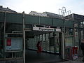 New building on outbound side
 -
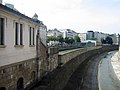 River Wien behind the station
 -
 Entrance to the Otto Wagner building on inbound side


References
- ^ Wiener Linien. "Access information" (in German).
- ^ Bundesdenkmalamt Österreich (8 November 2002). "Verordnung Wien 5, Margareten" (PDF) (in German).
- ^ Wiener Linien (28 April 2004). "Aufzugseinbauprogramm für die U-Bahn abgeschlossen". BIZEPS-INFO (in German). Retrieved 31 January 2011.
- ^ Wiener Linien (2011). "Ära Häupl - 1996". Geschichte der U-Bahn (in German). Archived from the original on 25 July 2011. Retrieved 31 January 2011.
{{cite web}}: Unknown parameter|deadurl=ignored (|url-status=suggested) (help) - ^ "Wiener Linien – Folder zur Sperre (pdf)" (PDF) (in German).