
Yarrawonga: Difference between revisions
Silverhorse (talk | contribs) No edit summary |
No edit summary Tags: Mobile edit Mobile web edit |
||
| (31 intermediate revisions by 25 users not shown) | |||
| Line 1: | Line 1: | ||
{{other uses}} |
|||
{{Redirect|Yarrawonga}} |
|||
{{ |
{{More citations needed|date=January 2022}} |
||
{{Use dmy dates|date=July 2022}} |
|||
{{Use Australian English|date=April 2013}} |
{{Use Australian English|date=April 2013}} |
||
{{Infobox Australian place |
{{Infobox Australian place |
||
| type = town |
| type = town |
||
| name = Yarrawonga |
| name = Yarrawonga |
||
| state = vic |
| state = vic |
||
| image = |
| image = |
||
YarrawongaStreetscape.JPG |
YarrawongaStreetscape.JPG |
||
| caption = Belmore street |
| caption = Belmore street |
||
| use_lga_map = yes |
| use_lga_map = yes |
||
| coordinates = {{coord|36|01|0|S|146|0|0|E|display=inline,title}} |
| coordinates = {{coord|36|01|0|S|146|0|0|E|display=inline,title}} |
||
| lga = Shire of Moira |
| lga = Shire of Moira |
||
| postcode = 3730 |
| postcode = 3730 |
||
| pop = |
| pop = 8,661 |
||
| pop_year = {{CensusAU| |
| pop_year = {{CensusAU|2020}} |
||
| pop_footnotes = <ref name="ABS2016">{{cite web |title=2016 Census QuickStats Yarrawonga |url=http://quickstats.censusdata.abs.gov.au/census_services/getproduct/census/2016/quickstat/SSC22904 | |
| pop_footnotes = <ref name="ABS2016">{{cite web |title=2016 Census QuickStats Yarrawonga |url=http://quickstats.censusdata.abs.gov.au/census_services/getproduct/census/2016/quickstat/SSC22904 |publisher=Australian Bureau of Statistics |access-date=24 January 2019}}</ref> |
||
| est = |
| est = |
||
| elevation= 128.9 |
| elevation = 128.9 |
||
| maxtemp = |
| maxtemp = |
||
| mintemp = |
| mintemp = |
||
| rainfall |
| rainfall = |
||
| stategov = [[Electoral district of |
| stategov = [[Electoral district of Ovens Valley|Ovens Valley]] |
||
| fedgov = [[Division of Nicholls|Nicholls]] |
| fedgov = [[Division of Nicholls|Nicholls]] |
||
| dist1 = 268 |
| dist1 = 268 |
||
| dir1 = N |
| dir1 = N |
||
| location1=[[Melbourne]] |
| location1 = [[Melbourne]] |
||
| dist2 = 92 |
| dist2 = 92 |
||
| dir2 = W |
| dir2 = W |
||
| location2 |
| location2 = [[Albury]] ([[New South Wales|NSW]]) |
||
| dist3 = 81 |
| dist3 = 81 |
||
| dir3 = NE |
| dir3 = NE |
||
| location3=[[ |
| location3 = [[Shepparton]] |
||
| dist4 = 89 |
| dist4 = 89 |
||
| dir4 = W |
| dir4 = W |
||
| location4=[[ |
| location4 = [[Wodonga]] |
||
| dist5 = 433 |
| dist5 = 433 |
||
| dir5 = SW |
| dir5 = SW |
||
| location5 |
| location5 = [[Canberra]] |
||
| near-nw = [[Burramine, Victoria|Burramine]] |
| near-nw = [[Burramine, Victoria|Burramine]] |
||
| near-n = ''[[New South Wales]]'' |
| near-n = ''[[Mulwala, New South Wales|Mulwala (NSW)]]'' |
||
| near-ne = ''[[New South Wales]]'' |
| near-ne = ''[[Mulwala, New South Wales|Mulwala (NSW)]]'' |
||
| near-w = [[Burramine, Victoria|Burramine]] |
| near-w = [[Burramine, Victoria|Burramine]] |
||
| near-e = [[Bathumi, Victoria|Bathumi]] |
| near-e = [[Bathumi, Victoria|Bathumi]] |
||
| near-sw = [[Telford, Victoria|Telford]] |
| near-sw = [[Telford, Victoria|Telford]] |
||
| near-s = [[Yarrawonga South, Victoria|Yarrawonga South]] |
| near-s = [[Yarrawonga South, Victoria|Yarrawonga South]] |
||
| near-se = [[Bundalong, Victoria|Bundalong]] |
| near-se = [[Bundalong, Victoria|Bundalong]] |
||
}} |
}} |
||
'''Yarrawonga''' {{IPAc-en|j|ær|ə|ˈ|w|ɒ|ŋ|ɡ|ə}}<ref>''[[Macquarie Dictionary|Macquarie Dictionary, Fourth Edition]]'' (2005). Melbourne, The Macquarie Library Pty Ltd. {{ISBN|1-876429-14-3}}</ref> is a town in the [[Shire of Moira]] [[Local government in Australia|local government area]] in the Australian state of [[Victoria (Australia)|Victoria]]. The town is situated on the south bank of the [[Murray River]], the border between Victoria and [[New South Wales]], and is located approximately {{convert|265|km|mi}} north-east of the state capital, Melbourne. Yarrawonga's twin town of [[Mulwala, New South Wales|Mulwala]] is on the other side of the [[Murray River]]. At the {{CensusAU|2016}}, Yarrawonga had a population of 7,930.<ref name=ABS2016/> |
|||
[[File:ForeshoreYarrawonga.JPG|thumb|250px|Foreshore of [[Lake Mulwala]] at Yarrawonga.]] |
|||
'''Yarrawonga''' {{IPAc-en|j|ær|ə|ˈ|w|ɒ|ŋ|ɡ|ə}}<ref>''[[Macquarie Dictionary|Macquarie Dictionary, Fourth Edition]]'' (2005). Melbourne, The Macquarie Library Pty Ltd. {{ISBN|1-876429-14-3}}</ref> is a town in the [[Shire of Moira]] [[Local government in Australia|local government area]] in the [[Australia]]n state of [[Victoria (Australia)|Victoria]]. The town is situated on the south bank of the [[Murray River]], the border between Victoria and [[New South Wales]] and is located approximately {{convert|265|km|mi}} north-east of the state capital, Melbourne. Yarrawonga's twin town of [[Mulwala, New South Wales|Mulwala]] is on the other side of the [[Murray River]]. At the {{CensusAU|2016}}, Yarrawonga had a population of 7,930.<ref name=ABS2016/> |
|||
Yarrawonga is served by a [[standard gauge]] branch railway, which branches off the Melbourne-Sydney line at Benalla and terminates at [[Oaklands, New South Wales|Oaklands]] in New South Wales. |
Yarrawonga is served by a [[standard gauge]] branch railway, which branches off the Melbourne-Sydney line at Benalla and terminates at [[Oaklands, New South Wales|Oaklands]] in New South Wales. |
||
[[File:YarrawongaTownHall.JPG|thumb|250px|Yarrawonga Town Hall.]] |
|||
[[File:Victoria Police checkpoint at Yarrawonga on January 12th 2021.jpg |left|thumb|250px|Covid-19 Victorian Border Checkpoint at Yarrawonga 12 January, 2021.]] |
|||
Yarrawonga's main attraction is [[Lake Mulwala]], formed by the damming of the Murray River. The lake is a popular location for activities such as boating, kayaking and fishing. There are two [[Murray River crossings|crossings]] of the Murray between Yarrawonga and Mulwala; across the weir (a [[stock route]] carrying a single lane of traffic); and a [[Mulwala Bridge|bridge over Lake Mulwala]]. This bridge contains an unusual bend and dip in the middle, a result of miscommunication between the two state governments.<ref>{{cite web | title = Early Transport & Bridges of Yarrawonga Mulwala | publisher = Yarrawonga Mulwala Tourism Inc | url = http://www.yarrawongamulwala.com.au/about/history/transport-bridges.html | access-date = 2016-02-06}}</ref> |
Yarrawonga's main attraction is [[Lake Mulwala]], formed by the damming of the Murray River. The lake is a popular location for activities such as boating, kayaking and fishing. There are two [[Murray River crossings|crossings]] of the Murray between Yarrawonga and Mulwala; across the weir (a [[stock route]] carrying a single lane of traffic); and a [[Mulwala Bridge|bridge over Lake Mulwala]]. This bridge contains an unusual bend and dip in the middle, a result of miscommunication between the two state governments.<ref>{{cite web | title = Early Transport & Bridges of Yarrawonga Mulwala | publisher = Yarrawonga Mulwala Tourism Inc | url = http://www.yarrawongamulwala.com.au/about/history/transport-bridges.html | access-date = 2016-02-06}}</ref> |
||
The [[Yarrawonga Football Club]] (the 'Mighty Pigeons') participates in the [[Ovens and Murray Football League]] in the sport of [[Australian rules football]], which has produced |
The [[Yarrawonga Football Club]] (the 'Mighty Pigeons') participates in the [[Ovens and Murray Football League]] in the sport of [[Australian rules football]], which has produced [[Barry Mitchell (footballer)|Barry Mitchell]], [[Joel Smith]], [[Ben Dixon (Australian rules footballer)|Ben Dixon]], and [[Tom Lonergan (Australian footballer)|Tom Lonergan]] as well as Caleb Mitchell.{{citation needed|date = December 2021}} |
||
==History== |
==History== |
||
Yarrawonga Post Office opened on 28 November 1874.<ref name = "a">{{Cite web | |
Yarrawonga Post Office opened on 28 November 1874.<ref name = "a">{{Cite web | website=Premierpostal.com| title = Post Office List | url = https://www.premierpostal.com/cgi-bin/wsProd.sh/Viewpocdwrapper.p?SortBy=VIC&country= | access-date = 2008-04-11}}</ref> |
||
Historically, one of the major industries in the Yarrawonga/ |
Historically, one of the major industries in the Yarrawonga/Mulwala area has been the explosives factory, which was constructed in Mulwala over 1942–43.<ref>{{Cite web |url=http://www.aph.gov.au/house/committee/pwc/mulwala/subs/sub1.pdf |title=Archived copy |access-date=20 July 2010 |archive-date=3 April 2011 |archive-url=https://web.archive.org/web/20110403224243/http://www.aph.gov.au/house/committee/pwc/mulwala/subs/sub1.pdf |url-status=dead }}</ref> It is now operated by French company Thales but remains an Australian Department of Defence asset.<ref>{{Cite web |url=http://www.thalesgroup.com/Markets/Defence/Home/ |title=Defence Home - Thales Group |access-date=20 July 2010 |archive-date=23 July 2010 |archive-url=https://web.archive.org/web/20100723125801/http://www.thalesgroup.com/Markets/Defence/Home/ |url-status=dead }}</ref> |
||
The Yarrawonga Magistrates' Court closed on 1 January 1990.<ref>{{cite web | url=https://www.parliament.vic.gov.au/images/stories/committees/lawrefrom/legal_services/final_report.pdf | title=Review of Legal Services in Rural and Regional Victoria | publisher=Parliament of Victoria Law Reform Committee | date=May 2001 | access-date=12 April 2020 |pages=291–292}}</ref> |
The Yarrawonga Magistrates' Court closed on 1 January 1990.<ref>{{cite web | url=https://www.parliament.vic.gov.au/images/stories/committees/lawrefrom/legal_services/final_report.pdf | title=Review of Legal Services in Rural and Regional Victoria | publisher=Parliament of Victoria Law Reform Committee | date=May 2001 | access-date=12 April 2020 |pages=291–292}}</ref> |
||
==Climate== |
|||
{{Weather box |
|||
|location = Yarrawonga (1993–2022) |
|||
|metric first = Yes |
|||
|single line = Yes |
|||
|rain colour = green |
|||
|Jan record high C = 46.0 |
|||
|Feb record high C = 46.0 |
|||
|Mar record high C = 39.9 |
|||
|Apr record high C = 36.7 |
|||
|May record high C = 28.9 |
|||
|Jun record high C = 23.0 |
|||
|Jul record high C = 21.0 |
|||
|Aug record high C = 25.7 |
|||
|Sep record high C = 34.0 |
|||
|Oct record high C = 36.4 |
|||
|Nov record high C = 42.4 |
|||
|Dec record high C = 44.3 |
|||
|year record high C = 46.0 |
|||
|Jan high C = 32.9 |
|||
|Feb high C = 31.6 |
|||
|Mar high C = 27.9 |
|||
|Apr high C = 23.1 |
|||
|May high C = 18.1 |
|||
|Jun high C = 14.5 |
|||
|Jul high C = 13.5 |
|||
|Aug high C = 15.2 |
|||
|Sep high C = 18.6 |
|||
|Oct high C = 22.8 |
|||
|Nov high C = 27.3 |
|||
|Dec high C = 30.3 |
|||
|year high C = 23.0 |
|||
|Jan low C = 16.1 |
|||
|Feb low C = 15.7 |
|||
|Mar low C = 12.9 |
|||
|Apr low C = 9.1 |
|||
|May low C = 6.1 |
|||
|Jun low C = 4.0 |
|||
|Jul low C = 3.5 |
|||
|Aug low C = 3.6 |
|||
|Sep low C = 5.1 |
|||
|Oct low C = 7.4 |
|||
|Nov low C = 11.2 |
|||
|Dec low C = 13.4 |
|||
|year low C = 9.0 |
|||
|Jan record low C = 4.4 |
|||
|Feb record low C = 4.7 |
|||
|Mar record low C = 3.3 |
|||
|Apr record low C = -0.5 |
|||
|May record low C = -1.9 |
|||
|Jun record low C = -5.3 |
|||
|Jul record low C = -4.4 |
|||
|Aug record low C = -6.0 |
|||
|Sep record low C = -3.4 |
|||
|Oct record low C = -1.4 |
|||
|Nov record low C = 0.6 |
|||
|Dec record low C = 2.2 |
|||
|year record low C = -6.0 |
|||
|Jan rain mm = 35.8 |
|||
|Feb rain mm = 41.0 |
|||
|Mar rain mm = 36.2 |
|||
|Apr rain mm = 32.2 |
|||
|May rain mm = 35.6 |
|||
|Jun rain mm = 43.0 |
|||
|Jul rain mm = 45.2 |
|||
|Aug rain mm = 39.5 |
|||
|Sep rain mm = 43.1 |
|||
|Oct rain mm = 42.1 |
|||
|Nov rain mm = 47.0 |
|||
|Dec rain mm = 40.0 |
|||
|year rain mm = 477.2 |
|||
|Jan rain days = 5.8 |
|||
|Feb rain days = 5.5 |
|||
|Mar rain days = 5.0 |
|||
|Apr rain days = 6.1 |
|||
|May rain days = 10.3 |
|||
|Jun rain days = 14.6 |
|||
|Jul rain days = 17.1 |
|||
|Aug rain days = 14.4 |
|||
|Sep rain days = 10.2 |
|||
|Oct rain days = 8.5 |
|||
|Nov rain days = 7.9 |
|||
|Dec rain days = 6.1 |
|||
|unit rain days = 0.2mm |
|||
|humidity colour = green |
|||
|Jan afthumidity = 29 |
|||
|Feb afthumidity = 32 |
|||
|Mar afthumidity = 33 |
|||
|Apr afthumidity = 42 |
|||
|May afthumidity = 54 |
|||
|Jun afthumidity = 65 |
|||
|Jul afthumidity = 66 |
|||
|Aug afthumidity = 58 |
|||
|Sep afthumidity = 53 |
|||
|Oct afthumidity = 43 |
|||
|Nov afthumidity = 34 |
|||
|Dec afthumidity = 29 |
|||
|source 1 = [[Bureau of Meteorology (Australia)|Bureau of Meteorology]]<ref>{{BoM Aust stats|site_ref=cw_081124_All|site_name=Yarrawonga|accessdate=27 April 2022|date=April 2022}}</ref> |
|||
|date=April 2022}} |
|||
==Popular culture== |
==Popular culture== |
||
* Niel McBeath wrote the song ' |
* Niel McBeath wrote the song "I'm Going Back Again to Yarrawonga", published in 1919 and later recorded by [[Ella Shields]] and [[Leonard Hubbard]] in 1992 and 1996. |
||
* Yarrawonga is also home to Australia's Tallest Man and Cleo's 2012 Bachelor of the Year runner-up Kewal Shiels, measuring {{convert|7|ft|3|in|cm|lk=on}}.{{citation needed|date=May 2021}} |
* Yarrawonga is also home to Australia's Tallest Man and Cleo's 2012 Bachelor of the Year runner-up Kewal Shiels, measuring {{convert|7|ft|3|in|cm|lk=on}}.{{citation needed|date=May 2021}} |
||
== |
==Gallery== |
||
{{commons}} |
|||
<gallery> |
|||
File:YarrawongaTownHall.JPG|Yarrawonga Town Hall |
|||
File:ForeshoreYarrawonga.JPG|Foreshore of [[Lake Mulwala]] at Yarrawonga |
|||
File:Victoria Police checkpoint at Yarrawonga on January 12th 2021.jpg|COVID-19 Victorian Border Checkpoint at Yarrawonga in January 2021 |
|||
</gallery> |
|||
== Notable people == |
|||
*[[Anne Curtis]], actress, TV host personality |
|||
==See also== |
|||
* [[Yarrawonga Airport]] |
* [[Yarrawonga Airport]] |
||
== |
==References== |
||
{{ |
{{Reflist}} |
||
== |
==External links== |
||
{{commons}} |
|||
* [http://shawfactor.com/gazetteer/victoria/yarrawonga/ Local history of Yarrawonga] |
* [http://shawfactor.com/gazetteer/victoria/yarrawonga/ Local history of Yarrawonga] |
||
* [http://www.moira.vic.gov.au Moira Shire Council] – Official website |
* [http://www.moira.vic.gov.au Moira Shire Council] – Official website |
||
| Line 86: | Line 193: | ||
{{authority control}} |
{{authority control}} |
||
[[Category:Towns in Victoria ( |
[[Category:Towns in Victoria (state)]] |
||
[[Category:Shire of Moira]] |
|||
[[Category:Populated places on the Murray River]] |
[[Category:Populated places on the Murray River]] |
||
Revision as of 09:48, 7 April 2024
This article needs additional citations for verification. (January 2022) |
| Yarrawonga Victoria | |||||||||||||||
|---|---|---|---|---|---|---|---|---|---|---|---|---|---|---|---|
 Belmore street | |||||||||||||||
 Yarrawonga | |||||||||||||||
| Coordinates | 36°01′0″S 146°0′0″E / 36.01667°S 146.00000°E | ||||||||||||||
| Population | 8,661 (2020 census)[1] | ||||||||||||||
| Postcode(s) | 3730 | ||||||||||||||
| Elevation | 128.9 m (423 ft) | ||||||||||||||
| Location | |||||||||||||||
| LGA(s) | Shire of Moira | ||||||||||||||
| State electorate(s) | Ovens Valley | ||||||||||||||
| Federal division(s) | Nicholls | ||||||||||||||
| |||||||||||||||
Yarrawonga /jærəˈwɒŋɡə/[2] is a town in the Shire of Moira local government area in the Australian state of Victoria. The town is situated on the south bank of the Murray River, the border between Victoria and New South Wales, and is located approximately 265 kilometres (165 mi) north-east of the state capital, Melbourne. Yarrawonga's twin town of Mulwala is on the other side of the Murray River. At the 2016 census, Yarrawonga had a population of 7,930.[1]
Yarrawonga is served by a standard gauge branch railway, which branches off the Melbourne-Sydney line at Benalla and terminates at Oaklands in New South Wales.
Yarrawonga's main attraction is Lake Mulwala, formed by the damming of the Murray River. The lake is a popular location for activities such as boating, kayaking and fishing. There are two crossings of the Murray between Yarrawonga and Mulwala; across the weir (a stock route carrying a single lane of traffic); and a bridge over Lake Mulwala. This bridge contains an unusual bend and dip in the middle, a result of miscommunication between the two state governments.[3]
The Yarrawonga Football Club (the 'Mighty Pigeons') participates in the Ovens and Murray Football League in the sport of Australian rules football, which has produced Barry Mitchell, Joel Smith, Ben Dixon, and Tom Lonergan as well as Caleb Mitchell.[citation needed]
History
Yarrawonga Post Office opened on 28 November 1874.[4]
Historically, one of the major industries in the Yarrawonga/Mulwala area has been the explosives factory, which was constructed in Mulwala over 1942–43.[5] It is now operated by French company Thales but remains an Australian Department of Defence asset.[6]
The Yarrawonga Magistrates' Court closed on 1 January 1990.[7]
Climate
| Climate data for Yarrawonga (1993–2022) | |||||||||||||
|---|---|---|---|---|---|---|---|---|---|---|---|---|---|
| Month | Jan | Feb | Mar | Apr | May | Jun | Jul | Aug | Sep | Oct | Nov | Dec | Year |
| Record high °C (°F) | 46.0 (114.8) |
46.0 (114.8) |
39.9 (103.8) |
36.7 (98.1) |
28.9 (84.0) |
23.0 (73.4) |
21.0 (69.8) |
25.7 (78.3) |
34.0 (93.2) |
36.4 (97.5) |
42.4 (108.3) |
44.3 (111.7) |
46.0 (114.8) |
| Mean daily maximum °C (°F) | 32.9 (91.2) |
31.6 (88.9) |
27.9 (82.2) |
23.1 (73.6) |
18.1 (64.6) |
14.5 (58.1) |
13.5 (56.3) |
15.2 (59.4) |
18.6 (65.5) |
22.8 (73.0) |
27.3 (81.1) |
30.3 (86.5) |
23.0 (73.4) |
| Mean daily minimum °C (°F) | 16.1 (61.0) |
15.7 (60.3) |
12.9 (55.2) |
9.1 (48.4) |
6.1 (43.0) |
4.0 (39.2) |
3.5 (38.3) |
3.6 (38.5) |
5.1 (41.2) |
7.4 (45.3) |
11.2 (52.2) |
13.4 (56.1) |
9.0 (48.2) |
| Record low °C (°F) | 4.4 (39.9) |
4.7 (40.5) |
3.3 (37.9) |
−0.5 (31.1) |
−1.9 (28.6) |
−5.3 (22.5) |
−4.4 (24.1) |
−6.0 (21.2) |
−3.4 (25.9) |
−1.4 (29.5) |
0.6 (33.1) |
2.2 (36.0) |
−6.0 (21.2) |
| Average rainfall mm (inches) | 35.8 (1.41) |
41.0 (1.61) |
36.2 (1.43) |
32.2 (1.27) |
35.6 (1.40) |
43.0 (1.69) |
45.2 (1.78) |
39.5 (1.56) |
43.1 (1.70) |
42.1 (1.66) |
47.0 (1.85) |
40.0 (1.57) |
477.2 (18.79) |
| Average rainy days (≥ 0.2mm) | 5.8 | 5.5 | 5.0 | 6.1 | 10.3 | 14.6 | 17.1 | 14.4 | 10.2 | 8.5 | 7.9 | 6.1 | 111.5 |
| Average afternoon relative humidity (%) | 29 | 32 | 33 | 42 | 54 | 65 | 66 | 58 | 53 | 43 | 34 | 29 | 45 |
| Source: Bureau of Meteorology[8] | |||||||||||||
Popular culture
- Niel McBeath wrote the song "I'm Going Back Again to Yarrawonga", published in 1919 and later recorded by Ella Shields and Leonard Hubbard in 1992 and 1996.
- Yarrawonga is also home to Australia's Tallest Man and Cleo's 2012 Bachelor of the Year runner-up Kewal Shiels, measuring 7 feet 3 inches (221 cm).[citation needed]
Gallery
-
 Yarrawonga Town Hall
 -
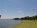 Foreshore of Lake Mulwala at Yarrawonga
 -
 COVID-19 Victorian Border Checkpoint at Yarrawonga in January 2021


Notable people
- Anne Curtis, actress, TV host personality
See also
References
- ^ a b "2016 Census QuickStats Yarrawonga". Australian Bureau of Statistics. Retrieved 24 January 2019.
- ^ Macquarie Dictionary, Fourth Edition (2005). Melbourne, The Macquarie Library Pty Ltd. ISBN 1-876429-14-3
- ^ "Early Transport & Bridges of Yarrawonga Mulwala". Yarrawonga Mulwala Tourism Inc. Retrieved 6 February 2016.
- ^ "Post Office List". Premierpostal.com. Retrieved 11 April 2008.
- ^ "Archived copy" (PDF). Archived from the original (PDF) on 3 April 2011. Retrieved 20 July 2010.
{{cite web}}: CS1 maint: archived copy as title (link) - ^ "Defence Home - Thales Group". Archived from the original on 23 July 2010. Retrieved 20 July 2010.
- ^ "Review of Legal Services in Rural and Regional Victoria" (PDF). Parliament of Victoria Law Reform Committee. May 2001. pp. 291–292. Retrieved 12 April 2020.
- ^ "Yarrawonga". Climate statistics for Australian locations. Bureau of Meteorology. April 2022. Retrieved 27 April 2022.
External links
- Local history of Yarrawonga
- Moira Shire Council – Official website
- Yarrawonga – Mulwala tourism
- Yarrawonga Railway Station & Silos
Localities in the Shire of Moira | ||
|---|---|---|
| Town | ||
| Locality |
| |
^ - Territory divided with another LGA | ||
| Authority control databases: Geographic |
|---|