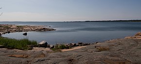
Åland Sea

Ålandsee , also Åländer See , Swedish Ålands hav , is part of the Baltic Sea and extends between the coast of the Swedish Uppland and the Finnish island of Åland .
geography
The nautical classification of the Baltic Sea Hydrologic Commission (BSHC) agreed in June 2014 classifies the Åland Sea as part of the Gulf of Bothnia . In the scientifically based structure of the Swedish surveying authority Lantmäteriet, only the northern part is assigned to that, the area south of the strait of Södra Kvarken (Südkvark), however, to the actual Baltic Sea.
The coasts of the Sea of Åland have warping on, but not so numerous as the Ålanders warping in the lying between Aland and mainland Finland Archipelago Sea (Archipelsee). The archipelago Märket , which is divided between Sweden and Finland, belongs to the Åland Sea archipelago .
In the channel running from northwest to southeast at the bottom of the Åland Sea is the second deepest point in the Baltic Sea at 301 meters.
traffic
From 1636 until the introduction of steam navigation , the mail route from Stockholm to Finland and after the assignment of Finland to Russia in 1743 led from there to St. Petersburg over the Sea of Åland and the Archipelago Sea (Archipelsee) to Turku, Finnish Turku . In winter, the mail boats were pulled across the ice as sleds.
There has been a ferry service from Kapellskär to Mariehamn across the Åland Sea since the 1960s .
Sources and references
- ^ Baltic Sea Hydrographic Commission
- ^ Swedish Meteorological and Hydrological Institute: The Baltic Sea, Kattegat and Skagerak - sea areas and drainage basins
- ↑ The postal route ran through Åland
Coordinates: 60 ° 11 ′ N , 19 ° 7 ′ E

