Anderson Islands
| Anderson Islands | ||
|---|---|---|
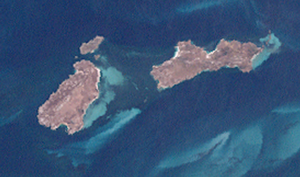
| Anderson Islands satellite image | ||
| Waters | Franklin Sound , Bass Street | |
| archipelago | Furneaux group | |
| Geographical location | 40 ° 18 ′ S , 148 ° 8 ′ E | |
|
|
||
| Number of islands | 4th | |
| Main island | Anderson Island | |
| Total land area | 3.5 km² | |
| Residents | uninhabited | |
The Anderson Islands ( English Anderson Islands ) are an uninhabited group of islands in the Bass Strait , the strait between mainland Australia and the island of Tasmania .
The group of four islands is part of the Furneaux Archipelago and is located in Franklin Sound about two kilometers off the south coast of Flinders Island ; Two kilometers to the south, the archipelago borders Cape Barren Island .
List of islands
![]() Map with all coordinates: OSM | WikiMap
Map with all coordinates: OSM | WikiMap
| Island name | Alias | Coordinates | surface | Residents |
|---|---|---|---|---|
| Anderson Island | Woody Island | 40 ° 18 ′ S , 148 ° 06 ′ E | 1.66 | - |
| Little Anderson Island | Little Woody Island | 40 ° 17 ′ S , 148 ° 07 ′ E | 0.13 | - |
| Mid Woody Island | 40 ° 18 ′ S , 148 ° 07 ′ E | 0.0066 | - | |
| Tin Kettle Island | 40 ° 18 ′ S , 148 ° 09 ′ E | 1.76 | - |

